Rimbach, Hesse
Rimbach in the Odenwald is a community in the Bergstraße district in southern Hesse, Germany.
Rimbach (Odenwald) | |
|---|---|
 Coat of arms | |
Location of Rimbach (Odenwald) within Bergstraße district 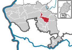  | |
 Rimbach (Odenwald) 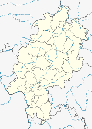 Rimbach (Odenwald) | |
| Coordinates: 49°37′24″N 8°45′36″E | |
| Country | Germany |
| State | Hesse |
| Admin. region | Darmstadt |
| District | Bergstraße |
| Government | |
| • Mayor | Holger Schmitt ((PuB)) |
| Area | |
| • Total | 23.16 km2 (8.94 sq mi) |
| Elevation | 174 m (571 ft) |
| Population (2018-12-31)[1] | |
| • Total | 8,656 |
| • Density | 370/km2 (970/sq mi) |
| Time zone | CET/CEST (UTC+1/+2) |
| Postal codes | 64666–64668 |
| Dialling codes | 06253 |
| Vehicle registration | HP |
| Website | www.rimbach-odw.de |
Geography
Location
The community lies in the Odenwald some 30 km north of Heidelberg and about 35 km northeast of Mannheim. It is found on Bundesstraße 38, and through it flows the Weschnitz.
Neighbouring communities
Rimbach borders in the north on the community of Fürth, in the east on the community of Grasellenbach, in the southeast on the community of Wald-Michelbach, in the south on the community of Mörlenbach and in the west on the town of Heppenheim.
Twinned Town with Little Haywood
England
Constituent communities
Rimbach’s Ortsteile are Albersbach, Lauten-Weschnitz, Mitlechtern, Münschbach, Unter-Mengelbach and Zotzenbach.
Climate
Owing to its location in Bergstraße district, a mild climate prevails in Rimbach, which often leads to what in Germany is a very early blossoming of the almond trees.
History
In 795, Rimbach had its first documentary mention, and in 1995 it celebrated its 1,200-year jubilee.
Politics
Community council
The municipal election in 2011 yielded the following results:
| Parties and voter communities |
% 2011 |
Seats 2011 |
% 2006 |
Seats 2006 |
% 2001 |
Seats 2001 | |
| SPD | 42,6 | 11 | 52,1 | 16 | 46,3 | 14 | |
| CDU | 25,5 | 6 | 23,2 | 7 | 25,2 | 8 | |
| GRÜNE | 13,8 | 4 | 5,4 | 2 | 5,0 | 2 | |
| Freie Wählergemeinschaft | 13,8 | 3 | 9,0 | 3 | 9,9 | 3 | |
| FDP | 4,4 | 1 | 5,8 | 2 | 6,1 | 2 | |
| Unabhängige Bürger Liste | – | – | 4,5 | 1 | 7,6 | 2 | |
| total | 100,0 | 25 | 100,0 | 31 | 100,0 | 31 | |
| Voter turnout in % | 52,7 | 64,2 | 57,6 | ||||
Mayor
Mayor Holger Schmitt (PuB) was elected in 2012 with 69.1% of the vote.
Town partnerships


Economy and infrastructure
Transport
Rimbach lies on the Weschnitztalbahn (railway) from Weinheim to Fürth in the Odenwald.
Moreover, Bundesstraße 38 runs through Rimbach. The Saukopftunnel, dedicated in 1999, made it possible to detour around Birkenau on Bundesstraße 38a, improving Rimbach’s road link with Weinheim and the Autobahn network. A new bottleneck, however, has cropped up at Mörlenbach, whose bypass is being planned.
Education
- 5 kindergartens
- 1 daycare centre
- 3 primary schools
- 1 Hauptschule and Realschule (RBS)
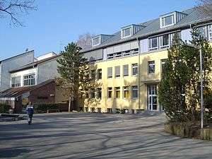
- 1 Gymnasium (Martin-Luther-Schule)
Culture and sightseeing
Theatre
- K.U.S.S. - Martin-Luther-Schule students’ theatre
- Jugendbühne - Martin-Luther-Schule students’ theatre
- Center Stage - English Theater - Martin-Luther-Schule students’ theatre
- Grünes Theater - KSG Mitlechtern
Regular events
Youth groups
- Katholische Junge Gemeinde (KJG) St. Elisabeth Rimbach (a tent camp every year)
- Christliche Pfadfinderschaft im CPD (Scouting)
- Jugendfeuerwehr (youth fire brigade)
- Jugendrotkreuz (Red Cross)
References
- "Bevölkerungsstand am 31.12.2018". Hessisches Statistisches Landesamt (in German). July 2019.
External links
| Wikimedia Commons has media related to Rimbach (Odenwald). |
Towns and municipalities in Bergstraße district | ||
|---|---|---|
Wappen des Landkreises Bergstraße | ||
| Authority control |
|---|