Renchinlkhümbe
Renchinlkhümbe (Mongolian: Рэнчинлхүмбэ) is a sum of Khövsgöl aimag. The area is about 8,850 square kilometres (3,420 sq mi), of which 2,910 square kilometres (1,120 sq mi) are pasture and 35% are forest. In 2000, the sum had 4284 inhabitants, mainly Darkhad. The sum center, officially named Zöölön (Mongolian: Зөөлөн), is located 265 kilometres (165 mi) north of Mörön and 998 kilometres (620 mi) from Ulaanbaatar.
Renchinlkhümbe District Рэнчинлхүмбэ сум ᠷᠢᠨᠴᠢᠨᡀᠦ᠋ᠩᠪᠦᠰᠤᠮᠤ | |
|---|---|
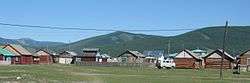 Renchinlkhümbe sum center | |
 Renchinlkhümbe District | |
| Coordinates: 51°6′31″N 99°40′15″E | |
| Country | Mongolia |
| Province | Khövsgöl Province |
| Time zone | UTC+8 (UTC + 8) |
History
The Renchinlkhümbe sum was founded, together with the whole Khövsgöl aimag, in 1931. In 1933, it had about 1,800 inhabitants in 544 households, and about 32,000 heads of livestock. The local Altan Tal (Golden Steppe) negdel was founded in 1956. The Zöölöngiin Khüree monastery (est. in 1750) had been located near what is now the sum center since 1771. Renchinlkhümbe was named after Jambyn Lkhümbe a member of the Presidium (or Politburo) of the Central Committee of the Mongolian People's Revolutionary Party (MPRP) from 1930 to 1933 and served as First Secretary of the MPRP Central Committee from July 30, 1932 to June 30, 1933.
Climate
Renchinlkhümbe has a subarctic climate (Köppen climate classification Dwc) with cool summers and bitterly cold winters. The average minimum temperature in January is −37.0 °C (−34.6 °F), and temperatures as low as −50 °C (−58 °F) have been recorded. Most precipitation falls in the summer as rain, with some snow in the adjacent months of May and September. Winters are very dry. With an average temperature −7.8 °C (18.0 °F) Renchinlkhümbe lies in the continuous permafrost zone.
| Climate data for Renchinlkhümbe | |||||||||||||
|---|---|---|---|---|---|---|---|---|---|---|---|---|---|
| Month | Jan | Feb | Mar | Apr | May | Jun | Jul | Aug | Sep | Oct | Nov | Dec | Year |
| Record high °C (°F) | −6.8 (19.8) |
1.9 (35.4) |
13.5 (56.3) |
19.1 (66.4) |
26.9 (80.4) |
29.3 (84.7) |
29.3 (84.7) |
30.8 (87.4) |
24.8 (76.6) |
21.6 (70.9) |
9.7 (49.5) |
2.2 (36.0) |
30.8 (87.4) |
| Average high °C (°F) | −27.7 (−17.9) |
−21.0 (−5.8) |
−8.8 (16.2) |
3.4 (38.1) |
12.9 (55.2) |
18.6 (65.5) |
19.6 (67.3) |
18.1 (64.6) |
12.7 (54.9) |
2.2 (36.0) |
−14.0 (6.8) |
−24.6 (−12.3) |
−0.7 (30.7) |
| Daily mean °C (°F) | −32.4 (−26.3) |
−27.6 (−17.7) |
−16.9 (1.6) |
−4.0 (24.8) |
4.9 (40.8) |
11.0 (51.8) |
12.6 (54.7) |
10.6 (51.1) |
4.6 (40.3) |
−6.0 (21.2) |
−20.4 (−4.7) |
−29.9 (−21.8) |
−7.8 (18.0) |
| Average low °C (°F) | −37.0 (−34.6) |
−34.0 (−29.2) |
−25.1 (−13.2) |
−11.2 (11.8) |
−2.9 (26.8) |
3.0 (37.4) |
5.8 (42.4) |
3.5 (38.3) |
−2.6 (27.3) |
−11.5 (11.3) |
−26.2 (−15.2) |
−34.1 (−29.4) |
−14.4 (6.1) |
| Record low °C (°F) | −50.1 (−58.2) |
−48.1 (−54.6) |
−41.2 (−42.2) |
−35.5 (−31.9) |
−17.5 (0.5) |
−6.7 (19.9) |
−2.5 (27.5) |
−7.8 (18.0) |
−13.8 (7.2) |
−35.6 (−32.1) |
−43.1 (−45.6) |
−48.1 (−54.6) |
−50.1 (−58.2) |
| Average precipitation mm (inches) | 2.5 (0.10) |
1.5 (0.06) |
2.8 (0.11) |
6.8 (0.27) |
19.0 (0.75) |
48.2 (1.90) |
78.5 (3.09) |
58.2 (2.29) |
30.1 (1.19) |
8.0 (0.31) |
5.5 (0.22) |
2.0 (0.08) |
263.1 (10.37) |
| Average precipitation days (≥ 1.0 mm) | 0.8 | 0.3 | 1.1 | 2.0 | 4.3 | 7.5 | 10.5 | 7.8 | 5.1 | 2.3 | 1.9 | 0.8 | 44.4 |
| Mean monthly sunshine hours | 208.8 | 199.3 | 221.2 | 235.2 | 296.2 | 310.2 | 317.9 | 324.5 | 305.4 | 290.2 | 245.6 | 215.2 | 3,169.7 |
| Source: NOAA (1973-1990) [1] | |||||||||||||
Economy
In 2004, there were roughly 95,000 heads of livestock, among them 34,000 sheep, 30,000 goats, 21,000 cattle and yaks, 9,200 horses, and 170 camels.[2]
Miscellaneous
The area forms part of the Darkhad valley (Darkhadyn Khotgor) and is considered remote and relatively inaccessible even for Mongolian standards. The local Darkhad are known for their practice of Shamanism. Erdeniin Bat-Üül worked as teacher in Renchinlkhümbe for several years.
Literature
M.Nyamaa, Khövsgöl aimgiin lavlakh toli, Ulaanbaatar 2001, p. 121f
References
- "Rinchinlhymbe Climate Normals 1973-1990". National Oceanic and Atmospheric Administration. Retrieved January 12, 2012.
- National Statistical Office: Livestock count 2004 (in Mongolian), p.111 Archived 2007-06-15 at the Wayback Machine