Redwing, Kansas
Redwing (also Red Wing[1]) is an unincorporated community in central Cheyenne Township, Barton County, Kansas, United States, in the central part of the state.[2] Located at 38°31′19″N 98°39′52″W (38.5219557, -98.6645233), it lies at an elevation of 1811 feet (552 m).[1] Redwing sits 1.5 miles (2.4 km) northwest of the northern edge of the Cheyenne Bottoms Wildlife Area, 6.0 miles (9.7 km) east of the city of Hoisington, and 7.0 miles (11 km) west of the city of Claflin.[2]
Redwing, Kansas | |
|---|---|
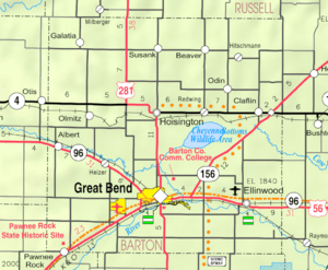 KDOT map of Barton County (legend) | |
 Redwing  Redwing | |
| Coordinates: 38°31′19″N 98°39′52″W | |
| Country | United States |
| State | Kansas |
| County | Barton |
| Elevation | 1,811 ft (552 m) |
| Time zone | UTC-6 (CST) |
| • Summer (DST) | UTC-5 (CDT) |
| Area code | 620 |
There was a grain elevator and tavern in years past. A post office operated in Redwing between 1892 and 1955.[3]
References
- U.S. Geological Survey Geographic Names Information System: Redwing, Kansas
- DeLorme. Kansas Atlas & Gazetteer. 4th ed. Yarmouth: DeLorme, 2009, p. 46, 47. ISBN 0-89933-342-7.
- "Kansas Post Offices, 1828-1961". Kansas Historical Society. Retrieved August 2, 2014.
Further reading
Municipalities and communities of Barton County, Kansas, United States | ||
|---|---|---|
| Cities | 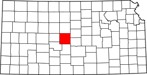 Map of Kansas highlighting Barton County | |
| CDPs | ||
| Unincorporated communities | ||
| Townships | ||
| Footnotes | ‡This populated place also has portions in an adjacent county or counties | |
This article is issued from Wikipedia. The text is licensed under Creative Commons - Attribution - Sharealike. Additional terms may apply for the media files.