Redvale, Colorado
Redvale is an unincorporated community and a U.S. Post Office located in Montrose County, Colorado, United States. The Redvale Post Office has the ZIP Code 81431.[2]
Redvale, Colorado | |
|---|---|
 Entering Redvale from the northwest on Highway 145 | |
 Location of Redvale in Montrose County, Colorado. | |
 Location in Montrose County and the state of Colorado  Redvale, Colorado (the United States) | |
| Coordinates: 38°10′29″N 108°25′04″W | |
| Country | |
| State | |
| County | Montrose County[1] |
| Elevation | 6,483 ft (1,976 m) |
| Time zone | UTC-7 (MST) |
| • Summer (DST) | UTC-6 (MDT) |
| ZIP code[2] | 81431 |
| Area code(s) | 970 |
| GNIS feature ID | 0204742 |
Geography
Redvale is located at 38°10′29″N 108°25′04″W (38.174782,-108.417721).
See also
- Outline of Colorado
- State of Colorado
- Colorado cities and towns
- Colorado census designated places
- Colorado counties
- Colorado metropolitan areas
- Montrose, CO Micropolitan Statistical Area
- Colorado cities and towns
References
- "US Board on Geographic Names". United States Geological Survey. 2007-10-25. Retrieved 2008-01-31.
- "ZIP Code Lookup" (JavaScript/HTML). United States Postal Service. January 2, 2007. Retrieved January 2, 2007.
- "Census of Population and Housing". Census.gov. Retrieved June 4, 2016.
Municipalities and communities of Montrose County, Colorado, United States | ||
|---|---|---|
| City | 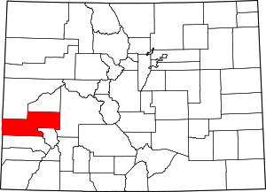 Map of Colorado highlighting Montrose County | |
| Towns | ||
| CDP | ||
| Unincorporated communities | ||
| Ghost town | ||
This article is issued from Wikipedia. The text is licensed under Creative Commons - Attribution - Sharealike. Additional terms may apply for the media files.