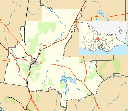
Redesdale, Victoria
Redesdale /ˈriːdsdeɪl/ is a town in central Victoria, Australia., 115 kilometres (71 mi) north west of the state capital, Melbourne. It is located partly in the City of Greater Bendigo local government area and partly in the Shire of Mount Alexander. At the 2016 census, Redesdale and the surrounding area had a population of 240.[1]
| Redesdale Victoria | |||||||||
|---|---|---|---|---|---|---|---|---|---|
 Catholic Church at Redesdale | |||||||||
 Redesdale | |||||||||
| Coordinates | 37°01′0″S 144°31′0″E | ||||||||
| Population | 240 (2016 census)[1] | ||||||||
| Postcode(s) | 3444 | ||||||||
| Elevation | 290 m (951 ft) | ||||||||
| Location | |||||||||
| LGA(s) | City of Greater Bendigo | ||||||||
| State electorate(s) | |||||||||
| Federal Division(s) | Bendigo | ||||||||
| |||||||||
History
The Post Office opened on 22 March 1865.[2]
Redesdale bridge
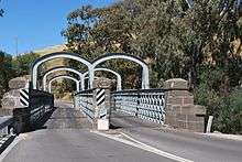
Redesdale is on the opposite bank of the Campaspe River from the town of Mia Mia. The towns are connected by the heritage listed Redesdale bridge,[3] one of the oldest iron lattice-truss bridges in Victoria. The trusses for the bridge were originally imported for a river crossing in suburban Hawthorn in 1859. The ship Herald of the Morning bringing the trusses to Melbourne caught fire and sank in Hobsons Bay. As a result, the Hawthorn Bridge, connecting Richmond and Hawthorn, was delayed for a couple of years while new trusses were made and shipped out to Australia.
Ten years later the original trusses were salvaged from the Herald of the Morning and used for the Redesdale Bridge. The bridge was constructed on site in 1868 with a divided-lane through-truss design created specifically for the difficult river crossing and unique in Victoria.[4]
Railway
Redesdale was once the terminus for a branch line railway which connected with the Melbourne - Murray River Railway at Redesdale Junction, between Kyneton and Malmsbury. Other stopping points on the line, going towards Redesdale, included Edgecombe, Green Hill, East Metcalfe, Emberton and Barfold.[5][6] The Redesdale line was opened on 15 January 1891 and closed on 29 June 1954.[5] The tracks and stations have since been removed.
Other
Redesdale is currently home to a primary school, a petrol station/general store, a historic bluestone pub/tavern and the Rural café.
References
- "2016 Census QuickStats Redesdale". Australian Bureau of Statistics. Retrieved 19 January 2019.
- Premier Postal History. "Post Office List". Retrieved 11 April 2008.
- "Redesdale Bridge, Victorian Heritage Register (VHR) Number H1419, Heritage Overlay HO230". Victorian Heritage Database. Heritage Victoria. Retrieved 29 March 2011.
- "Mia Mia Bridge". Heritage Council of Victoria. Retrieved 18 July 2007.
- Rowe, Bill (1989). Redesdale: Yesterday and Today. Redesdale, Victoria: self published. p. 33.
- Railway Map of Victoria, Australia, 1946 map reproduced courtesy V/Line, Railway Museum, North Williamstown, Victoria, 1988
| Wikimedia Commons has media related to Redesdale, Victoria. |