Red River Fault
The Red River Fault or Song Hong Fault (Vietnamese: Đới Đứt Gãy Sông Hồng) is a major fault in Yunnan, China and Vietnam which accommodates continental China's (Yangtze Plate) southward movement[1] It is coupled with that of the Sagaing Fault in Burma, which accommodates the Indian plate's northward movement, with the land (Indochina) in between faulted and twisted clockwise. It was responsible for the 1970 Tonghai earthquake.
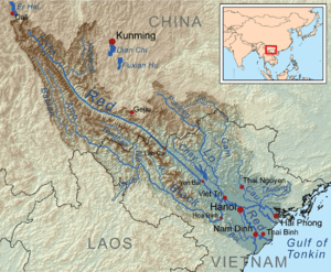
Topographic map showing the Red River and fault

The Red River (Nansha Reservoir) seen from the slope of its deep valley, south of Potou Township, Jianshui County
It is named after the Red River which runs through its rift valley.
Red River is a sinistral strike-slip fault situated at a NW-SE orientation.[2]
References
- "Archived copy". Archived from the original on 2012-12-23. Retrieved 2012-11-07.CS1 maint: archived copy as title (link)
- Watkinson et al. 2008
| Plate tectonics |
| |
|---|---|---|
| Faults and rift zones | ||
This article is issued from Wikipedia. The text is licensed under Creative Commons - Attribution - Sharealike. Additional terms may apply for the media files.