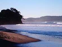
Red Beach, New Zealand
Red Beach is a suburb surrounding the beach of the same name on the Hibiscus Coast, Auckland, New Zealand, at the base of the Whangaparaoa Peninsula. The suburb of Silverdale is to the south-west, and Orewa to the north. The beach is on the Hauraki Gulf and the suburb is bounded by two estuaries, that of the Weiti River to the south and the Orewa River to the north.
Red Beach | |
|---|---|
| Country | New Zealand |
| Local authority | Auckland Council |
| Electoral ward | Albany ward |
| Population (2018)[1] | |
| • Total | 8,346 |
| (Orewa River) | Orewa | |
| Millwater |
|
(Whangaparaoa Bay) |
| Silverdale | (Weiti River) | Stanmore Bay |

The Hibiscus Coast Highway runs through the suburb. This was previously State Highway 1[2] and then State Highway 17. The majority of highway traffic now travels along the Northern Motorway inland instead, as the motorway was redesignated as State Highway 1 when an extension was completed in 2009. All road access to the rest of Whangaparaoa Peninsula currently runs through the suburb.
Demographics
| Historical population | ||
|---|---|---|
| Year | Pop. | ±% p.a. |
| 2006 | 6,423 | — |
| 2013 | 7,551 | +2.34% |
| 2018 | 8,346 | +2.02% |
| Source: [1] | ||
Red Beach (comprising the statistical areas of Red Beach West, Red Beach East, and Kingsway) had a population of 8,346 at the 2018 New Zealand census, an increase of 795 people (10.5%) since the 2013 census, and an increase of 1,923 people (29.9%) since the 2006 census. There were 3,027 households. There were 3,975 males and 4,374 females, giving a sex ratio of 0.91 males per female, with 1,548 people (18.5%) aged under 15 years, 1,368 (16.4%) aged 15 to 29, 3,531 (42.3%) aged 30 to 64, and 1,908 (22.9%) aged 65 or older.
Ethnicities were 88.9% European/Pākehā, 7.5% Māori, 2.5% Pacific peoples, 7.3% Asian, and 2.6% other ethnicities (totals add to more than 100% since people could identify with multiple ethnicities).
The proportion of people born overseas was 29.7%, compared with 27.1% nationally.
Although some people objected to giving their religion, 47.5% had no religion, 42.6% were Christian, and 3.2% had other religions.
Of those at least 15 years old, 1,554 (22.9%) people had a bachelor or higher degree, and 990 (14.6%) people had no formal qualifications. The employment status of those at least 15 was that 3,177 (46.7%) people were employed full-time, 1,095 (16.1%) were part-time, and 174 (2.6%) were unemployed.[1]
Landmarks and attractions
Popular attractions include:
- The Red Beach Surf Club
- Totara Views
- Red Beach
- Red Beach Shops
Annual events
- Red Beach School Gala
- Streetlight Competition
Education
Red Beach School is a contributing primary (years 1–6) school with a decile rating of 9 and a roll of 643.[3] The school opened in 1989 covering years 1–8, but reduced its age range when Hibiscus Coast Intermediate opened in 1997 (the intermediate later became part of Whangaparaoa College).[4]
KingsWay School is a state integrated composite (years 1–13) school with a decile rating of 9 and a roll of 1122.[5][6] The school provides a non-denominational Christian-based education.[7]
Both schools are coeducational.
Notes
- "Statistical area 1 dataset for 2018 Census". Statistics New Zealand. March 2020. Red Beach West (113900), Red Beach East (114000) and Kingsway (113600). 2018 Census place summary: Red Beach West 2018 Census place summary: Red Beach East 2018 Census place summary: Kingsway
- Peter Dowling (editor) (2004). Reed New Zealand Atlas. Reed Books. pp. map 11. ISBN 0-7900-0952-8.CS1 maint: extra text: authors list (link)
- "Te Kete Ipurangi – Red Beach School". Ministry of Education. Archived from the original on 18 October 2002.
- "About Our School – General Information". Red Beach School. Retrieved 26 August 2008.
- "Te Kete Ipurangi – Kingsway School". Ministry of Education. Archived from the original on 18 October 2002.
- "Kingsway School - 08/11/2017". Education Review Office. Retrieved 19 July 2019.
- "Education Review Report – KingsWay School". Education Review Office. April 2006. Retrieved 26 August 2008.
External links
- Red Beach School website
- KingsWay School website
- Photographs of Red Beach held in Auckland Libraries' heritage collections.