Orewa
Orewa is a suburb of Auckland, New Zealand’s largest city. It lies on the Hibiscus Coast, just north of the base of the Whangaparaoa Peninsula and 40 kilometres north of central Auckland. It is a popular holiday destination.
Orewa | |
|---|---|
 Shops in Orewa town centre | |
 Orewa  Orewa | |
| Coordinates: 36°34′53.6″S 174°42′23.8″E | |
| Country | New Zealand |
| Local authority | Auckland Council |
| Electoral ward | Albany ward |
| Population (2013) | |
| • Total | 8,523 |
| Hatfields Beach | ||
| Wainui |
|
(Whangaparaoa Bay) |
| Silverdale | Red Beach | Stanmore Bay |
The Northern Motorway, part of State Highway 1, passes just inland of Orewa and extends through the twin Johnston Hill tunnels to near Puhoi. Orewa was administered as part of the Rodney District for two decades, until this was subsumed into the new Auckland Council in October 2010.
Landmarks and features
Places of note within the town include:
- Orewa Community Centre
- The Youth centre (including a skate park)
- The Orewa Surf Life-Saving Club
- Centrestage Theatre
- The water fountains by the traffic lights on the main road
- The Nautilus apartment complex
- The Statue of Sir Edmund Hillary
- Alice Eaves Scenic Reserve ("Eaves Bush")
- The Orewa Bridge
- The Estuary Arts Centre[1]
- The Theosophical Centre
- The former Rodney District Council building on Centreway Road
- The Orewa Arts And Events Centre
- The Orewa River (with mangroves)
- Hibiscus Coast Community Centre
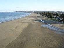
Orewa beach is one of the longest (3 km) and safest beaches in Auckland. One of the more notable events on the beach is the Orewa Big Dig. This is an annual event organized by the local Lions Club, where children dig in the sand to find prizes. All monies raised go to local community groups.[2] Orewa Community Centre[3] is located in Orewa Square. The Hibiscus Community Centre[4] is located at 214E Hibiscus Coast Highway.
Demographics
| Historical population | ||
|---|---|---|
| Year | Pop. | ±% p.a. |
| 2006 | 7,371 | — |
| 2013 | 8,589 | +2.21% |
| 2018 | 10,242 | +3.58% |
| Source: [5] | ||
Orewa, comprising the three statistical areas of Orewa Central, Orewa North and Orewa South, had a population of 10,242 at the 2018 New Zealand census, an increase of 1,653 people (19.2%) since the 2013 census, and an increase of 2,871 people (38.9%) since the 2006 census. There were 4,389 households. There were 4,599 males and 5,643 females, giving a sex ratio of 0.81 males per female, with 1,287 people (12.6%) aged under 15 years, 1,170 (11.4%) aged 15 to 29, 3,720 (36.3%) aged 30 to 64, and 4,062 (39.7%) aged 65 or older.
Ethnicities were 86.1% European/Pākehā, 6.1% Māori, 2.7% Pacific peoples, 11.0% Asian, and 1.9% other ethnicities (totals add to more than 100% since people could identify with multiple ethnicities).
The proportion of people born overseas was 35.8%, compared with 27.1% nationally.
Although some people objected to giving their religion, 42.2% had no religion, 47.6% were Christian, and 4.3% had other religions.
Of those at least 15 years old, 1,707 (19.1%) people had a bachelor or higher degree, and 1,683 (18.8%) people had no formal qualifications. The employment status of those at least 15 was that 3,210 (35.8%) people were employed full-time, 1,107 (12.4%) were part-time, and 165 (1.8%) were unemployed.[5]
Education
Orewa District High School was founded in 1956. In 1974, the school was split into Orewa School and Orewa College. Orewa North School was founded in 1978, and another primary school opened at Red Beach to the south in 1988.[6]
Orewa College is a secondary (years 7-13) school with a roll of 1977 students.[7]
Orewa School and Orewa North School are contributing primary (years 1-6) schools, with rolls of 424 students[8] and 380 students[9] respectively.
All three schools are coeducational. Rolls are as of March 2020.[10]
Puriri Park
In 2005 locally famous Puriri Park, at the foot of Eaves Bush, was sold for over $2,000,000. It was being subdivided in a $450 million development to form the community of Kensington Park to provide for the rapidly rising demand for housing in Orewa and the surrounding area. This upset some elderly locals as they regarded the old park as a popular place for people to enjoy their holidays and saw the development as a sign of further development to Orewa. However the developer went into receivership in September 2008 after completing less than 10% of the 750 homes planned.[11]
References
- http://estuaryarts.org/
- "Major crowd likely for 30th Big Dig". Stuff.co.nz. 6 January 2009. Retrieved 1 November 2011.
- "Archived copy". Archived from the original on 2011-07-21. Retrieved 2011-01-14.CS1 maint: archived copy as title (link)
- http://www.hbccommunityhouse.org.nz/
- "Statistical area 1 dataset for 2018 Census". Statistics New Zealand. March 2020. Orewa North (112700), Orewa South (112900) and Orewa Central (113000). 2018 Census place summary: Orewa North 2018 Census place summary: Orewa South 2018 Census place summary: Orewa Central
- "Our School". Orewa Primary School. Retrieved 2008-08-24.
- Education Counts: Orewa College
- Education Counts: Orewa School
- Education Counts: Orewa North School
- "New Zealand Schools Directory". New Zealand Ministry of Education. Retrieved 26 April 2020.
- Gibson, Anne (22 September 2008). "$450m housing project crashes". New Zealand Herald.