Ravansar
Ravansar (Persian: روانسر; also Romanized as Ravānsar and Rawānsīr)[2] is a city and capital of Ravansar County, Kermanshah Province, Iran. At the 2006 census, its population was 16,383, in 3,838 families.[3]
Ravansar روانسر | |
|---|---|
City | |
 Ravansar | |
| Coordinates: 34°42′55″N 46°39′12″E | |
| Country | |
| Province | Kermanshah |
| County | Ravansar |
| Bakhsh | Central |
| Population (2016 Census) | |
| • Total | 24,527 [1] |
| Time zone | UTC+3:30 (IRST) |
| • Summer (DST) | UTC+4:30 (IRDT) |
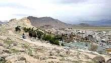
Ravansar Spring is a huge karst spring located prominently in the city of Ravansar. The area around Ravansar is karstified, the karst ground water emerges in various springs like homonymous Ravansar Spring, which are very important for the supply of drinking water and as the main source of Qara Su River.
Archaeology
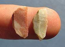
Ravansar has important prehistoric and historical sites, and in this respect it has a special place in the archaeology of the west of Iran. The earliest evidence of human habitation around Ravansar extend back to the Middle Paleolithic that continues to end of glacial period (at least from about 50,000 years to 12,000 years ago), whose remains were found in the caves of the Kolian and Jawri, as well as the Garab River (Awi Kher).[4] Another important discovery at the region is an elephant molar tooth that dates back to the Pleistocene era and has been discovered near Rawansar. Other important archaeological site is Musaei mound and its two nearby smaller mounds, it has been inhabited since the end of Neolithic period (about 8,000 years ago).
In the course of the Assyrian campaigns into Zagros, Rawansar was one of the bases of this Mesopotamian government that called Nikour, and it was used as a military base in which Assyrian soldiers gathered horses and other goods that were sent to Assyria.[5] Stronach and Calmeyer proposed Ravansar as a possible candidate for the place of Bit-Istar, an Assyrian town and a local kingdom (c. 12th century BC - c. 710 BC) at western Zagros. [6]The rock-cut tomb of Rawansar or Dekhmeh Rawansar, which local people call "Kōshk", is located in the eastern face of a limestone rock in the northeast of Ravansar, which dates back to Achaemenid period.[7] The tomb consists of a small chamber that opens to the east and overlooks the slope. The figure of Ahura Mazda, a person and mass of firewood, appears on the right side of the entrance to this tomb. There is also a pillar base next to the Goni Khani Spring, called "Takhti Zangi", which may have been created at the same time as the tomb, indicating the presence of a palace or smaller buildings near the spring.[8] Therefore, during the Achaemenid period, Rawansar was probably one of the important centers of this government in the west of the country. In the Parthian period, Rawansar was a small town in the west of the present town which today is close to a spring called Kani Wayan (near the police station). From the Sassanid period, a collection of silverware has been discovered in Quri Qala Cave. There was also a cemetery from the Safavid period on the northern slopes of Qola Mount. The gravestones exhibiting the Kofi scripts, which unfortunately have been looted or broken in recent decades. This Safavid cemetery shows the importance of Ravansar in the Safavid period.
Main Archaeological sites
- Musaei mounds, (from the end of the Neolithic Age - about 8,000 years ago - up to Islamic period)
- Kolian Cave and Jawri Cave (from the Middle Paleolithic Period - about 50 thousand years ago - until the end of the Epialeolithic Period - about 12 thousand years ago)
- Rock-cut tomb of "Koshk" (Achaemenid Period)
- Kani Wayan (the Parthian Period)
- Islamic Cemetery (Safavid Period and Qajar)
References
- https://www.amar.org.ir/english
- Ravansar can be found at GEOnet Names Server, at this link, by opening the Advanced Search box, entering "-3080921" in the "Unique Feature Id" form, and clicking on "Search Database".
- "Census of the Islamic Republic of Iran, 1385 (2006)". Islamic Republic of Iran. Archived from the original (Excel) on 2011-11-11.
- Biglari, F., Taheri, K. 2000. The discovery of Upper Paleolithic remains at Mar Kulian and Mar Dalan caves, Rawansar. In: Taheri, K. (Ed.), Essays on the Archaeology, Geology, and Culture of Rawansar Area, Kermanshah. Taq-e Bostan Publications, pp. 7-27 (In Persian).
- Parpola, S. & M. Porter (2001) The Helsinki Atlas of the Near East in the Neo-Assyrian Period, Edited by: Simo Parpola & Michael Porter, The Casco Bay Assyriological Institute The Neo-Assyrian Text Corpus Project, Finland.
- Radner, K., (2003) "A Median Sanctuary at Bit-Ištar". In G.B. Lanfranchi, M. Roaf & R. Rollinger (ed.), Continuity of Empire: Assyria, Media, Persia. History of the Ancient Near East Monographs 5 (Padova 2003) 119-130.
- Calmeyer, Peter 1978, “Das Grabrelief von Ravansar,” AMI N.S. 11, pp. 73–85.
- Golzari, Massoud., 1994 The Ravansar rock-cut tomb, and three Islamic tombstones. Proceedings of the First Archaeological Symposium in Iran after the Islamic Revolution, Susa, 14–17 April 1994.
- Taheri, K (2000). taheri.kamal (ed.). Essays on the Archaeology, Geology, Geography, and Culture of Rawansar Area. Kermanshah: Taq-e Bostan Publications. ISBN 964-5551-79-X.
See also
- Dekhmeh Rawansar
- Khanileh, Kermanshah
- Jaff tribe
- Ardalan
- Javanrud
- Paveh
| Capital |  | |
|---|---|---|
| Counties and cities | ||
| Sights |
| |
| populated places | ||