Ratchadamnoen Avenue
Ratchadamnoen Avenue (Thai: ถนนราชดำเนิน, RTGS: Thanon Ratchadamnoen, pronounced [tʰā.nǒn râːt.t͡ɕʰā.dām.nɤ̄ːn], also spelled Rajdamnern) is a historic road in the Phra Nakhon and Dusit Districts of Bangkok, Thailand.[1] Ratchadamnoen Avenue may be the most politically charged thoroughfare in the capital, as its history captures the ebb and flow of Thai ideological struggles over Thai governance in the 20th and 21st centuries.[2]

Description
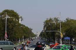
Ratchadamnoen Nai Road begins at the northeast corner of the Grand Palace and leads northward to the Phan Phiphop Lila Bridge, which crosses the old city moat. The road then continues east as Ratchadamnoen Klang until it crosses Khlong Rop Krung (the outer moat) at Phan Fa Lilat Bridge, where it turns northward toward the Royal Plaza. Ratchadamnoen Nok, in particular, was designed to impart Western-style grandeur, with three carriageways with wide pavements lined by multiple rows of trees. Today, the avenue serves as a major thoroughfare bringing traffic into the old city centre and across Phra Pin-klao Bridge to the Thonburi side of the city. It is bordered by government offices including Government House. Democracy Monument sits in the centre of Ratchadamnoen Klang Road. The avenue has been the site of many demonstrations, including the 1973 student uprising as well as more recent political rallies.[3]
History
Ratchadamnoen Avenue was commissioned by King Chulalongkorn following his first visit to Europe in 1897. Construction took place from 1899 to 1903.[4] The road consists of three segments, named Ratchadamnoen Nai, Ratchadamnoen Klang, and Ratchadamnoen Nok (Inner, Middle, and Outer Ratchadamnoen, respectively). It links the Grand Palace to Dusit Palace in the new royal district, terminating at the Royal Plaza in front of the Ananta Samakhom Throne Hall. Inspired by the Champs-Élysées and other European boulevards, the King used the road as a route for grand royal parades (Ratchadamnoen literally means 'royal procession'), which served to project images of a modern monarchy.[5][6]
In January 2020 it was announced that ten buildings flanking a 1.2 kilometre stretch of the avenue, owned by the Crown Property Bureau, would be renovated or demolished. The bureau proposes rebuilding the structures in "neoclassical-style", obliterating the Art Deco theme originally inspired by the spirit of the 1932 revolution that overthrew absolute monarchy.[2]
References
- Wallophodom, Srisakraw (4 May 2016). "ราชดำเนิน ถนนสัญลักษณ์แห่งการเปลี่ยนแปลงเมืองแบบโบราณสู่เมืองสมัยใหม่" [Ratchadamnoen Road, from ancient city to modern city]. Lek-Prapai Viriyahpant Foundation. Retrieved 26 January 2020.
- Rojanaphruk, Pravit (23 January 2020). "SCHOLAR FEARS MASSIVE RENOVATION OF ICONIC AVENUE MAY ERASE HISTORY". Khaosod English. Retrieved 26 January 2020.
- Khruethong, Pramin (10 December 2017). "ตึกแถวสองฟากถนนราชดำเนิน "ป้อมปราการ" ประชาธิปไตย" [Commercial buildings on both sides of Ratchadamnoen Road: 'fortress' democracy]. Retrieved 26 January 2020.
- Askew, Marc (2002). Bangkok: Place, Practice & Representation. Routledge. p. 36. ISBN 9780415188531.
- O'Neil, Maryvelma (2008). Bangkok: A Cultural History. Oxford University Press. pp. 96–97. ISBN 9780195342529.
- LAKSANASAMRITH, EKKARACH. "รอยต่อสถาปัตยกรรมบนถนนราชดำเนิน ต้นแบบความงามจากเมืองน้ำหอม" [Architectural boundaries on Ratchadamnoen Road; Beauty model from Perfume City]. Dsign Something [sic]. Retrieved 26 January 2020.
External links
