Rasdorf
Rasdorf is a municipality in the district of Fulda, in Hesse, Germany.
Rasdorf | |
|---|---|
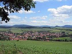 View of Rasdorf from Gehilfersberg | |
 Coat of arms | |
Location of Rasdorf within Fulda district 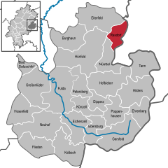  | |
 Rasdorf  Rasdorf | |
| Coordinates: 50°43′N 09°54′E | |
| Country | Germany |
| State | Hesse |
| Admin. region | Kassel |
| District | Fulda |
| Government | |
| • Mayor | Berthold Körbel |
| Area | |
| • Total | 30.07 km2 (11.61 sq mi) |
| Elevation | 332 m (1,089 ft) |
| Population (2018-12-31)[1] | |
| • Total | 1,608 |
| • Density | 53/km2 (140/sq mi) |
| Time zone | CET/CEST (UTC+1/+2) |
| Postal codes | 36169 |
| Dialling codes | 06651 |
| Vehicle registration | FD |
| Website | www.rasdorf.de |
Geography
Rasdorf is situated within the Kuppenrhön-part of the Rhön hills, at the border of Hesse and Thuringia.
Administration
The districts of Rasdorf, Setzelbach and Grüsselbach form the municipality of Rasdorf.
History
Rasdorf was mentioned for the first time in 780.
Sights
The memorial Point Alpha is located at the border of Hesse and Thuringia, which was the Inner German border until 1990. For decades, an observation post of the US army was located here. Today, the "Point Alpha Foundation" strives to maintain a section of the inner German border fortifications and the American observation post as a memorial. The intention is to remind visitors of the division of Germany and the confrontation between NATO and Warsaw Pact forces.[2]
See also
References
- "Bevölkerungsstand am 31.12.2018". Hessisches Statistisches Landesamt (in German). July 2019.
- Kania, Martin (20 July 2009). "Gedenkstätte Point Alpha - Der heißeste Ort des Kalten Krieges (German)". HR-online. Retrieved 29 April 2013.
External links
| Wikimedia Commons has media related to Rasdorf. |
- www.rasdorf.de (in German)
- Point Alpha, official website
Towns and municipalities in Fulda district | ||
|---|---|---|
Wappen des Landkreises Fulda | ||
| Authority control |
|
|---|