Ranjit Sagar Dam
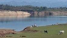
The Ranjit Sagar Dam, also known as the Thein Dam, is part of a hydroelectric project constructed by the Government of Punjab Punjab Irrigation Department on the Ravi River on the Border of two states of India Jammu and Kashmir and Punjab. 60% of the lake is part of J&K. The project is situated near Pathankot city in Pathankot district of the state of Punjab and Kathua city and Basholi tehsil of Kathua district in J&K. The project is the largest hydroelectric dam of the state of Punjab. The township where the site is located is called Shah pur Kandi Township. Feasibility studies for the project began in 1953 and geotechnical studies continued until 1980. Construction began in 1981, the generators were commissioned in 2000 and the project complete in March 2001.[4]
| Ranjit Sagar Dam | |
|---|---|
 Location of Ranjit Sagar Dam in Punjab  Ranjit Sagar Dam (India) | |
| Country | India |
| Location | Basholi & Pathankot |
| Coordinates | 32°26′33″N 75°43′43″E |
| Status | Operational |
| Construction began | 1981 |
| Opening date | 2001 |
| Owner(s) | Water Resources(Irrigation) Department,Government of Punjab,India |
| Dam and spillways | |
| Type of dam | Embankment, earth-fill |
| Impounds | Ravi River |
| Height | 160 m (525 ft) |
| Length | 617 m (2,024 ft) |
| Elevation at crest | 540 m (1,772 ft) |
| Width (crest) | 14 m (46 ft) |
| Width (base) | 669.2 m (2,196 ft) |
| Dam volume | 21,920,000 m3 (28,670,278 cu yd)[1] |
| Spillway type | Controlled-chute |
| Spillway capacity | 24,637 m3/s (870,047 cu ft/s) |
| Reservoir | |
| Total capacity | 3,280,000,000 m3 (2,659,139 acre⋅ft) |
| Active capacity | 2,344,000,000 m3 (1,900,312 acre⋅ft) |
| Normal elevation | 527.9 m (1,732 ft) |
| Power Station | |
| Commission date | 2000[2] |
| Hydraulic head | 121.9 m (400 ft) (max)[3] |
| Turbines | 4 x 150 MW Francis-type |
| Installed capacity | 600 MW |

The project is used for both irrigation purposes and power generation. It has a 600 Megawatt capacity. The dam is one of the highest earth-fill dams in India and has the largest diameter penstock pipes in the country.
Several issues and claims were consistently reported by the govt of J&K to govt of Punjab over the usage of water, electricity, employment and compensation to the locals against the land acquisition. Finally on 12 May 2017 govt of J&K has raised this issue in the Northern Zonal Council Meeting held in Chandigarh on this Ministry of Home Affairs, GOI has decided to construct barrage to allow both states to enjoy equal rights over the dam. Barrages will help J&K in irrigation in Samba and Kathua districts in Jammu division of J&K. Punjab govt has also agreed to share electricity produced through the project. But the previous claims of J&K remained unsettled. In 2017 Govt of J&K has claims worth 8000 crores for the loss against govt of Punjab, on which the Punjab govt has never shown any interest to square them off. It is located upstream of the Madhopur Barrage at Madhopur.[3]
References
| Wikimedia Commons has media related to Ranjit Sagar Dam. |
- "India: National Register of Large Dams 2009" (PDF). Central Water Commission. Retrieved 22 November 2011.
- "Ranjit Sagar Dam". Punjab State Power Corporation Ltd. Archived from the original on 2 May 2008. Retrieved 24 November 2011.
- "Ranjitsagar Dam". Central Water Commission. Retrieved 24 November 2011.
- "An Overview of Ranjit Sagar Dam Project, Gurdaspur District, Punjab" (PDF). Geological Survey of India. Retrieved 24 November 2011.