Ranch to Market Road 620
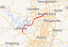
Ranch to Market Road 620, Ranch Road 620, or RM 620 is a Ranch to Market Road in the U.S. state of Texas maintained by the Texas Department of Transportation (TxDOT). The 27.1-mile (43.6 km) road begins at SH 71 in Bee Cave in Travis County west of Austin passing along southeastern Lake Travis, western Austin, and several suburban communities west and north of Austin before ending at Bus. I-35-L in Round Rock in Williamson County. The road has major intersections with I-35, US 183, and SH 45.
| ||||
|---|---|---|---|---|
| ||||
| Route information | ||||
| Length | 23.329 mi[1] (37.544 km) | |||
| Existed | 1945[1]–present | |||
| Major junctions | ||||
| West end | ||||
| East end | ||||
| Location | ||||
| Counties | Travis, Williamson | |||
| Highway system | ||||
| ||||

The road opened in 1945 as a Farm to Market Road. The road is now officially designated by TxDOT as Urban Road 620, but all Urban Roads in Texas retain their former Farm or Ranch to Market highway signs.
History

RM 620 was originally designated on July 9, 1945 as Farm to Market Road 620 from Round Rock to SH 29,[1] the former designation of US 183 south of Liberty Hill until May 23, 1951.[2][3] On May 13, 1946, the road was extended to the Travis County line.[1] On August 26, 1948, the road was extended to the former community of Hickmuntown,[1] also called Four Points, at the location of the current intersection with RM 2222.[4] The road was completed on December 17, 1952 when it was extended to SH 71,[1] known locally before August 31, 1965 as RM 93 (but was signed as SH 71 since October 31, 1955).[5] The road received its Ranch to Market designation on October 1, 1956,[1] and its Urban Road designation on June 27, 1995.[1][6] The SH 45 toll road running along a portion of RM 620 opened in 2006.[7] On February 28, 2013, the section from IH-35 to BI 35-L was cancelled and given to the city of Round Rock, along with part of BI 35-L itself. On June 27, 2019, RM 620 Spur was designated from RM 620 northeast to RM 2222 along the westernmost portion of PASS 1402 (Arterial 8)[8]; however, RM 620 Spur has not been constructed yet.[9]
Route description
The western terminus of RM 620 is at SH 71 in Bee Cave in Travis County. From there, it travels north through the city of Lakeway, following along southeastern Lake Travis until it crosses the Colorado River at Mansfield Dam near Marshall Ford. To the northeast, RM 620 enters the city of Austin and intersects RM 2222. The road then intersects RM 2769 just inside the Williamson County line. To the east, the road travels concurrently with the free service roads of the SH-45 toll road crossing US-183, the 183A Toll Road, and FM 734 before separating from SH 45 and entering Round Rock. The road intersects I-35 before terminating at Bus. I-35-L in Round Rock.[10]
Major intersections
| County | Location | mi[11] | km | Destinations | Notes |
|---|---|---|---|---|---|
| Travis | Bee Cave | 0 | 0.0 | Western terminus | |
| Austin | 12.9 | 20.8 | |||
| Travis–Williamson county line | 16.9 | 27.2 | Part of the northbound right-turn lane is located in Travis County; the rest of the intersection lies in Williamson County | ||
| Williamson | 18.5 | 29.8 | Begin overlay of SH 45 over non-tolled service roads at SH 45 western terminus | ||
| 18.9 | 30.4 | ||||
| 20.9 | 33.6 | ||||
| | 22.2 | 35.7 | End overlay of SH 45 | ||
| Round Rock | 26.7 | 43.0 | |||
| 27.1 | 43.6 | Eastern terminus | |||
| 1.000 mi = 1.609 km; 1.000 km = 0.621 mi | |||||
References
- Transportation Planning and Programming Division (n.d.). "Ranch to Market Road No. 620". Highway Designation Files. Texas Department of Transportation. Retrieved 2010-11-16.
- Transportation Planning and Programming Division (n.d.). "State Highway No. 29". Highway Designation Files. Texas Department of Transportation. Retrieved 2010-11-16.
- Transportation Planning and Programming Division (n.d.). "U.S. Highway No. 183". Highway Designation Files. Texas Department of Transportation. Retrieved 2010-11-16.
- Smyrl, Vivian Elizabeth. "Four Points, TX". Handbook of Texas Online. Texas State Historical Association. Retrieved 2010-11-16.
- Transportation Planning and Programming Division (n.d.). "State Highway No. 71". Highway Designation Files. Texas Department of Transportation. Retrieved 2010-11-16.
- Transportation Planning and Programming Division (n.d.). "Urban Road No. 620". Highway Designation Files. Texas Department of Transportation. Retrieved 2010-11-16.
- "More of SH 45 North toll road to open early" (PDF). Texas Department of Transportation. October 10, 2006. Retrieved 2010-11-17.
- http://www.dot.state.tx.us/tpp/hwy/pa/pa1402.htm. Missing or empty
|title=(help) - (PDF) http://ftp.dot.state.tx.us/pub/txdot/commission/2019/0627/12d.pdf. Missing or empty
|title=(help) - County Grid Map (Map) (2010 ed.). 1:120,000. Texas Department of Transportation. p. 430-431. Archived from the original (PDF) on 2010-10-12. Retrieved 2010-11-17.
- Google (2010-11-16). "Route of RM 620" (Map). Google Maps. Google. Retrieved 2010-11-16.
Crossings of the Colorado River | ||||
|---|---|---|---|---|
| ||||
Austin streets | |
|---|---|
| Streets |
|
| Bridges | |
| Routes |
|
| FM/RM | |