Ramireno, Texas
Ramireno is a census-designated place (CDP) in Zapata County, Texas, United States. This was a new CDP for the 2010 census with a population of 35.[1]
Ramireno, Texas | |
|---|---|
| Coordinates: 27°0′46″N 99°22′39″W | |
| Country | United States |
| State | Texas |
| County | Zapata |
| Area | |
| • Total | 1.5 sq mi (4 km2) |
| • Land | 1.5 sq mi (4 km2) |
| • Water | 0.0 sq mi (0 km2) |
| Population (2010) | |
| • Total | 35 |
| • Density | 23/sq mi (9.0/km2) |
| Time zone | UTC-6 (Central (CST)) |
| • Summer (DST) | UTC-5 (CDT) |
| Zip Code | 78067 |
| FIPS code | 4860380 |
History
It was located on land granted to Don José Luis Ramírez by the King of Spain in 1784, part of the colonization effort of Col. José de Escandón. Ramírez, resident of Revilla (now Guerrero), Nuevo Santander (now Tamaulipas), along with his wife María Bacilia Martínez, and their children moved across the Rio Grande and established a home on their land in present Zapata County. They had ten children, and their families and descendants formed the nucleus of the community of Ramireño.
Geography
Ramireno is located at 27°0′46″N 99°22′39″W (). The CDP has a total area of 1.5 square miles (3.9 km2), all land.[2]
References
- "Population and Housing Unit Counts, 2010 Census of Population and Housing" (PDF). Texas: 2010. Retrieved 9 January 2017.
- "US Gazetteer Files 2016-Places-Texas". US Census. Retrieved 9 January 2017.
Municipalities and communities of Zapata County, Texas, United States | ||
|---|---|---|
| CDPs | 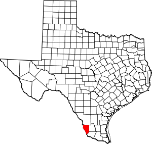 Zapata County map | |
This article is issued from Wikipedia. The text is licensed under Creative Commons - Attribution - Sharealike. Additional terms may apply for the media files.