Rakina bara
Rakina Bara (Serbian: Ракина Бара) is a lake in Sremčica, a suburb of Belgrade, Serbia. It is located in the municipality of Čukarica.
| Rakina Bara Ракина Бара | |
|---|---|
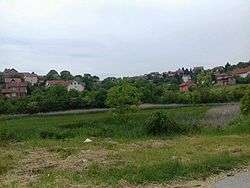 Rakina Bara covered with overgrowth | |
| Coordinates | 44.680734°N 20.393034°E |
| Primary inflows | nameless creek |
| Primary outflows | none |
| Basin countries | Serbia |
| Max. length | 170 m (560 ft) |
| Max. width | 110 m (360 ft) |
| Surface area | 3 ha (7.4 acres) |
| Max. depth | 1 m (3 ft 3 in) |
| Surface elevation | 180 m (590 ft) |
| Islands | none |
| Settlements | Sremčica |
Location
The lake is located in the central section of Sremčica, 20 km (12 mi) south of downtown Belgrade.
Geography
Rakina Bara is situated in the limestone pit, in the karstic micro-region called Belgrade merokras.[1] It is embedded into the mass wasting area and, typically for the karst lakes, has a sinkhole. It is the largest natural lake in the Šumadija section of Belgrade and the only karst lake in the city territory. Rakina bara is one of six (formerly 15) karst lakes in the entire Šumadija region. The lake is oval-shaped, 170 m (560 ft) long, 110 m (360 ft) wide and 1 m (3 ft 3 in) deep. It is situated at an altitude of 180 m (590 ft) and covers an area of 3 ha (7.4 acres).[2] Rakina Bara receives water from two springs and atmospheric precipitation. It has no outflows.
The name of the lake means "Raka's Pond" in Serbian (Raka is a male nickname).
Wildlife
Plants
As the lake shrank, it was gradually buried under the overgrowth, mostly made of the reed-like plants.[3]
Animals
Lake used to be abundant in fish as in the 1950s in was turned into the fish pond. Carps up to 5 kg (11 lb) were fished with nets and until the early 2000s fishing competitions were organized. Today almost all of the fish in the lake died out and an occasional snake, duck or grebe can be spotted.[3][4]
Human interaction
Rakina Bara was originally deeper and the water was clear all the way to the bottom. At the location where the creek flew into the lake, local farmers watered their cattle. As the shore was sandy and the mud was only present at the deepest, central part of the lakebed, it was used for swimming. It was one of the earliest nudist locations in Serbia, dating back top the beginning of the 20th century. Later, it became a popular lover's lane for the city couples.[4]
In the 1950s it was populated with several species of fish, turning it into the fish pond. Plans were made to arrange the shores, build the restaurants and turn it into the tourist center and a recreational area, but the local authorities were not interested, so the plans were abandoned.[4]
Sremčica experienced a massive population growth since the 1970s and the population grew from 2,445 in 1971 to 13,193 in 1981 and 21,001 in 2011.[5] As the settlement grew, it engulfed the lake and the surrounding area was urbanized. In the 21st century lake was reduced in size as the local population, in order to get more land, illegally dug outflow canals to drain the water and even threw mercury into the sinkhole to erode the land and make the sinkhole wider in order to drain water more quickly. Households from the neighboring slopes turned their sewage pipes into Rakina Bara emptying their cesspits in the pond. The pond was also turned into a dump, with garbage of all kinds being dumped in it. As the lake reduced in size, the spring which brings the majority of water into it, for the most part of the year stopped reaching the lake as it is close to the sinkhole so it flows directly into the ground through it, practically turning the pond into a large cesspool. As the water drains through the earth, it widens the holes in it producing the cracks in the ground already prone to the mass wasting. Basically digging the land under the lake, it might set mass wasting in motion which would bury the pond completely. In the 2010s, Rakina Bara was on the brink of completely dying out.[3][4]
Shores of the pond were cleaned to some extent in 2008. At that time, the study on saving the pond was done. Proposed short term interventions included cleaning of the garbage from the lake and the surrounding area, emptying and closing of the cesspits and ban on building on the slopes above the pond. Further, long-term measures should include the chemical and bacteriological analysis of the water, creation of the "wet field" which would naturally filter the water, channeling of the creek to reach the pond again and the restoration of the sinkhole. Another study from 2012 proposed that the pond should be saved with the construction of the sewage system and by placing Rakina bara under protection. However, the pond and the surroundings are too polluted, thus not fulfilling the basic conditions for protection. As for the other proposals, none of them turned into projects, due to either lack of funds (municipality of Čukarica) or the typical bureaucratic "it is not my jurisdiction" attitude (city, communal companies, nature protection agencies).[2][6]
In time, the water almost completely disappeared from the lake and the mass wasting became active. In November 2019, eco-activists cleaned the creek, conducting it again into the lake. The creek's route was dredged with an excavator, removing large quantities of clay, garbage and sludge and growths of reed and wild blackberry. The creek's inflow into the lake increased from an average 10 to 50 l/min (0.037 to 0.183 impgal/s), so after one month the water level in the lake reached midcalf. During the 2019/2020 winter, it even froze. However as the bottom of the lake was neither cleaned nor surveyed, the creek was again rerouted into the sinkhole. The bottom will be surveyed for possible sinkholes and if it will be needed to remove the sludge.[7]
By the early 2020, the sewage system was built for the surrounding houses, so wastewater stopped flowing into the creek and the lake. Further cleaning ensued in February 2020. There were suggestions of making a clay plug to block the sinkhole in the future. However, further steps from the 2007 study (geodetic surveys, chemical analyses of the soil, access road), are outside of the eco-activists hands and cooperation from the local administration and communal services is needed.[7]
References
- Jovan Đ. Marković (1990). Enciklopedijski geografski leksikon Jugoslavije. Svjetlost-Sarajevo. ISBN 86-01-02651-6.
- Branka Vasiljević, "Jedinstveno jezero u prestonici prekrili rogoz i šaš", Politika (in Serbian)
- Vladimir Vukasović, Branka Vasiljević (17 September 2008). "Spasavanje Rakine bare" (in Serbian). Politika.
- Vladimir Vukasović, Branka Vasiljević (15 September 2008). "Zemlja guta Rakinu baru" (in Serbian). Politika.
- Comparative overview of the number of population in 1948, 1953, 1961, 1971, 1981, 1991, 2002 and 2011 – Data by settlements, page 32. Statistical Office of the Republic of Serbia, Belgrade. 2014. ISBN 978-86-6161-109-4.
- Branka Vasiljević (28 February 2020). Борба за Ракину бару се наставља [Fight for Rakina Bara continues]. Politika (in Serbian). p. 17.
- Branka Vasiljević (10 February 2020). "Novi život Rakine bare" [New life of Rakina Bara]. Politika (in Serbian). p. 14.
External links
| Wikimedia Commons has media related to Rakina Bara. |