Raet
Raet is the largest terminal moraine in Scandinavia. It was formed during the end of the last glacial period, 12,800–11,500 years ago, in one of the latest advances of the glaciers.

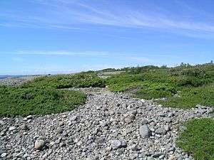
As the glacier retreated towards the end of this period, it could stop for hundreds of years before moving forward again. Material that the glacier brought from the inland, such as particles of rocks, gravel, sand and clay, gathered where the edge of the ice laid still for some time. Such deposits, which are partly deposited on land and partly in ocean, are called terminal moraine.
As the ice pulled back and the land rose, these deposits were left behind in the landscape. Later these deposits have been affected by sea and precipitation so that the roughest material remains on the surface. If you dig yourself through a terminal moraine, it is the variation in the size of the particles that are striking; it consists of unsorted material.
.JPG)
Several steps of terminal moraines or ra-steps in Norway can be identified. The oldest are located in the sea and along the sea, the youngest in the mountain valleys.
From ancient times, parts of Raet have been important as a route in Norway, especially in Vestfold and Østfold.
The word "ra"
The word ra is of Old Norwegian origin and means a ridge of gravel. The word is used in Norwegian as a general term about terminal moraine.
This structure goes a long way over land and elsewhere under water.
In Vestfold and Østfold, this geological formation is very visible and well-known. The Ra step was deposited for about 10,600 years ago around a glacier covering most of Scandinavia and had its center above what is today Bottenviken.
Raet as the name of this long ridge through Vestfold is very old; in Horten municipality lies a farm called Ra. The word is used as farm name in many places in Norway, this is farms located on terminal moraines.
Today, knowledge of moraines and the ice age is taken as granted, but the knowledge about this is only about 150 years old. Geology research on moraines and the Ice Age took place in the mid-1800s, and it took a long time before an understanding of how the ra-step forms a coherent structure around the ice with Bottenviken as the center.
Ra-trinnet
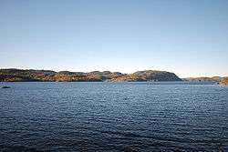
The Ra-step can be followed from Finland through Sweden to Northern Norway, some places in the sea, elsewhere far inland. From Sweden the ra-step can be followed into Østfold at Halden - Moss, it crosses Oslofjorden at Jeløya and reaches Horten, continues through Vestfold og Telemark, follows highway 19 to Gulli, then old E18 to Larvik, through Bøkeskogen, over the Farris eidet and continues beyond Brunlanes, extends into the sea and is visible above sea level as islands along Telemark and Aust-Agder: Mølen, Jomfruland, Merdø and some other small islands.
East of Fevik in Grimstad, Raet goes on land and continues west to Rogaland and along Western Norway, Trøndelag and Northern Norway.
In Trøndelag, the ra-step is called Tautra because the ice edge crossed the Trondheimsfjord at Tautra.
Raet dams up several lakes. In Østfold Vannsjø is among the seas that are created in this way, and in Vestfold this applies to Borrevannet, Goksjø and Farris as well as the lake Rore in Grimstad.
Ytre Raet
There is also a somewhat older maternity disposition a little beyond the big Raet, or Ra-stage, and this is often called Ytre Raet. This older stage is 250 years older than the main stage. The geographic distance between Raet and Ytre Raet varies, and the distance is greatest through Sandefjord, Nøtterøy and Tønsberg where Ytre Raet crosses the northern part of Nøtterøy and continues in Slagen, Ringshaug and Skallevold. In Brunlanes and at Fredrikstad and Halden the distance is shorter between the two ra-steps.
Ytre Raet contributes to large, good agricultural areas in the municipalities of Sandefjord, Nøtterøy and Tønsberg.
The road at Raet
Raet is used as place name for large parts of the ra through Østfold and Vestfold.
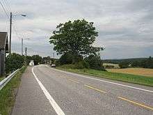
Raet was in old age a convenient route, because there were so few watercourses to cross. When Bishop Jens Nilsson went on visits to Østfold and Bohuslän in the late 16th century, he traveled along Raet because it was easily accessible. Still E6 in Østfold and E18 in Vestfold follow Raet for long distances.
Raet also attracted settlements, so that the oldest, largest and best farms are still there. Similarly tumuli in Iron Age often was located along Raet.[1]
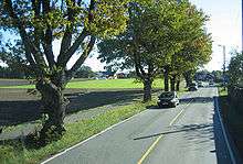
The top of the moraine has been used as road from prehistoric times, and in some places Raveien is the name of the road.
E18 long followed this old trace in Vestfold from Sem to Farriseidet. Now the road in the main traces follows a trace inside the raid.
In Østfold, E6 follows Raet from Halden to Moss.
The place Helgeroa in Vestfold, near the Mølen, where Raet descended on the seabed, became a central place for a period of communication precisely because the location lay there the natural road in the direction of the east through Vestfold.
Protection
Several areas of raet are protected as national parks, landscaping areas and nature reserves.
Two national parks are on the Raet: Jomfruland National Park in Telemark and Raet National Park in Aust-Agder. In Vestfold Mølen and Bøkeskogen in Larvik and Bøkemoa in the Sandefjord protected.
Gea Norvegica Geopark has as one of its tasks to convey knowledge about the importance of geology, and has information boards, among other things, on the Mølen in Brunlanes in Larvik municipality.
Steps in ice melting in Eastern Norway
In Eastern Norway, the different stages of ice melting are clearly marked in the landscape with endemorins in several stages.
The provisions in Eastern Norway are best investigated, and the moral steps in Eastern Norway have therefore become a reference framework in the national context.
Mostly, it has been so that the ice has moved forward at the same time in a larger area.
The oldest ra-step to be seen in Oslofjord is called Tjøme-Hvaler-step and is approximately 11,200 years old.
The next step is called Ytre Raet and is approximately 10,850 years old, while the main stage, Ra-Step, is approx. 10,600 years old.
Younger is the Ås-Ski-step, which forms the threshold for Inner Oslofjord. This is about 10,200–10,400 years old. Large sand areas are deposited as the ice lay at Drøbak-Svelvik.
The next stop for the ice edge is called the Aker-step in the Groruddalen where the deposits demolishes Maridalsvannet, Bogstadvannet and Sognsvann. In Sylling, the acronym dams up Holsfjorden. The Aker step is approx. 9,800 years old.
On Romerike there are several steps of which Gardermoen or Hauerseter is the most marked with large sandboxes. This is about 9,600 years old.
Then the Minnesund-step is the last before the ice melted. This is about 9,500 years old.
References
- Einar Østmo: Arkeologi for alle (s. 94), Landbruksforlaget, Oslo 1998, ISBN 82-529-1156-0