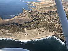
Mølen
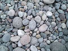
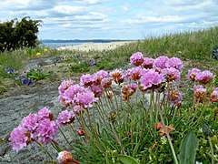
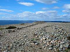
Mølen in Brunlanes, Larvik is Norway's largest beach of rolling stones, and is a part of Vestfoldraet, the terrain left behind after the end of the most recent ice age around 10,000 years ago.[1][2][3] Mølen is one of Larvik's most popular tourist attractions. It is home to over a hundred species of rock, including Norway's national stone, Larvikite, which is named from the area.[4][5]

The wind and sea have lashed the landscape of Mølen for thousands of years, and the place takes its name from the Old Norse word "mol", meaning a stone mound or bank of stones.
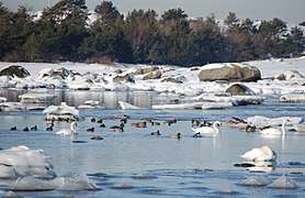
Mølen first received protected status in 1939 due to its ancient burial mounds.[6] Mølen is home to over 230 cairns, some exceeding 35 metres (115 ft) in diameter. Excavations have dated the rock piles to about 250 A.D.[7][8] It received a new protection status in 1970 due its rich and unusual avifauna.[9] Mølen is a habitat for a variety of rare bird species.[10] Between 316[11] and 320 species of birds have been recorded at Mølen, more species than at any other site in Norway.[12]
It became the first UNESCO Global Geopark in the Nordics in 2008.[13][14]
Cultural history
The cultural landscape of Mølen, with its total of 230 cairns, is one of the most notable in Norway. The area has 16 large cairns, many up to 35 metres (115 ft) in diameter, with almost 200 small cairns in rows parallel to the shoreline. In one of the cairns, burnt stones were found; this could be the result of a cremation dating back to the 5th century A.D. The small cairns may symbolize warriors who fell in battle or were shipwrecked together with their captain.
Plundering
The cairns closest to the sea are from the late Iron Age and Viking times, while those on higher ground are probably older; theoretically, they could be from the late Bronze Age, as was previously assumed. However, recent research shows that all the cairns of Mølen are probably from the Iron Age. Almost all the cairns have one or more depressions from plundering or so-called "haugbrot". "Haugbrot" refers to ritual removal of the dead; the reason why this was done is not clear. The low boat-shaped stone setting was excavated in the 1970s. It is a grave where a ship had probably been burnt. Iron nails and carbon were found, and these have been dated to approximately 30?250 A.D.
Different social strata
It is not clear why some graves are mounded, while others are of simpler form. It is unknown what ceremonies were linked to the burials, but it is likely that the most powerful members of society were given the most impressive grave sites, while ordinary people received simpler types of graves or were buried without any mound, cairn or bauta stones as grave markers.
Trading centre
The cairns, which were clearly visible to shipping, not only signaled prosperity but probably also served as "sea markers" along the shipping lanes between different trading centres. Mølen and its bay could have been one of several transit sites in Eastern Norway, with goods from here being exchanged and conveyed to the surrounding settlements.
Geology
There are traces of volcanic activity from the Brunlane volcano on Saltstein, a southerly headland with a beach composed almost entirely of pebbles. The volcano itself (~280 Ma) has eroded, but the dark types of rock on Saltstein (called larvikites, unique syenite location of this type in the world, but for a minor occurrence in central Canada. Lazareth Claire, Univ. La Rochelle, 1998. "http://www.theses.fr/fr/169734501") are remnants of the defunct shield volcano. Relics have also been found on Oddane Fort, on the skerries between Oddane, and other places further south.
Lava, volcanic ash and corridors
The long headland of Saltstein comprises alternating layers of lava and volcanic ash. The lava is in the form of dark types of rock with white flecks. The white flecks were originally gas-filled bubbles. Volcanic ash can be seen in layers between individual layers of lava; it is often very stratified and green or brownish in colour. The ash resulted from volcanic eruptions. In the far west of Saltstein, there is an approximately 4-metre (13 ft) thick layer of fragments of rock of various sizes. This layer was created in a massive volcanic eruption. Molten basalt and rhomb porphyry forced its way up through the volcano after the lava had overflowed. These substances can be seen as east-west corridors on Saltstein.
Special volcanic activity
Later in the carbon time series, there was basaltic volcanic activity near Skien, Holmestrand, Jeløya and on Krokskogen and Kolsås, south of Oslo. This was the earliest volcanic activity in the Oslo area. The lava flows were similar to those on basal volcanoes such as on Iceland, Mount Etna and Hawaii. The Brunlane volcano has a very particular composition found today in eastern Congo near the town of Goma.
Glaciation
The smooth, sloping rock of Saltstein was ground by the glacier during the last ice age. Abraded strips show that the glacier moved from north to south. The North Sea Trail from Nevlunghavn or Helgeroa passes through the area. It is part of a 5,000-kilometre (3,100 mi) coastal walk in Norway, Sweden, Denmark, Germany, Netherlands, England and Scotland.
Environmental disasters
In the summer of 2009, Mølen was covered in oil by the Full City oil spill. A subsequent study found that the marine and fish life suffered no significant changes.
Gallery
References
- https://www.atlasobscura.com/places/molen
- https://www.lonelyplanet.com/norway/attractions/molen/a/poi-sig/1544033/1329870
- http://www.gonorway.com/norway/articles/5380
- https://issuu.com/visitvestfold/docs/visit_larvik_2018-2019_web (Page 26).
- https://www.visitvestfold.com/en/larvik/see-and-do/Attractions/?TLp=1121470&Molen
- https://www.vestfoldguide.no/molen-vestfold/
- https://www.atlasobscura.com/places/molen
- http://www.gonorway.com/norway/articles/5380
- https://www.vestfoldguide.no/molen-vestfold/
- https://snl.no/M%C3%B8len_-_i_Larvik
- Larsen, Erlend (2011). På Tur i Vestfold del 2. E-forlag. Page 250. ISBN 9788293057222.
- https://vestfold.guide/mlen-rullesteinstrand/
- https://www.op.no/nyheter/apnet-geopark-pa-molen-og-i-lardal/s/1-85-3609340
- https://www.vestfoldguide.no/molen-vestfold/