Radomka
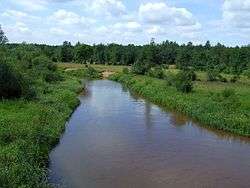
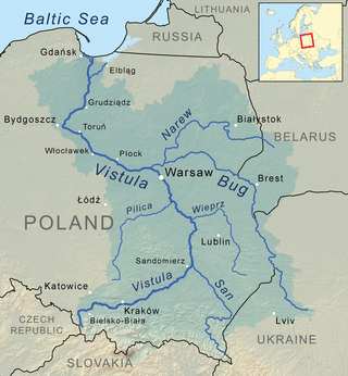
The Radomka is a river in central Poland and a left tributary of the Vistula. It has a length of 98 km and a basin area of over 2000 km² (all in Poland). The river has its source in forests 4 km south from Przysucha, at the height of 310 meters above sea level. There is a retention reservoir, built in the valley of the Radomka in Domaniów, which has the largest surface area of any lakes in Mazowsze Voivodeship (5 – 7 km²). It is also utilised for recreation purposes.
| Radomka | |
|---|---|
 | |
| Location | |
| Country | Poland |
| Physical characteristics | |
| Mouth | |
⁃ location | Vistula |
⁃ coordinates | 51.7087°N 21.4353°E |
| Basin features | |
| Progression | Vistula→ Baltic Sea |
After flowing through the hills of the Lesser Poland Upland, the Radomka enters a wide urstromtal, to finally enter the Vistula near Ryczywol, at the height of 160 meters above sea level.
Puszcza Nature Reserve
The reserve, located in a forest at the source of the Radomka, was opened in 1978. Its purpose is to preserve natural wilderness, with its fir and beech trees.
Main tributaries
- Mleczna
- Narutówka
- Jastrzębianka
- Szabasówka
Sources
Tributaries of the Vistula River | ||
|---|---|---|
| Forming rivers |
|  |
| Main tributaries of the left bank | ||
| Main tributaries of the right bank |
| |
| Distributary | ||