Rüdersdorf
Rüdersdorf is a municipality in the district Märkisch-Oderland, in Brandenburg, Germany, near Berlin.
Rüdersdorf | |
|---|---|
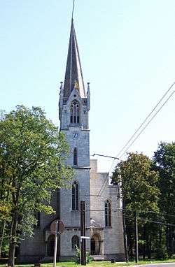 Protestant church | |
 Coat of arms | |
Location of Rüdersdorf within Märkisch-Oderland district 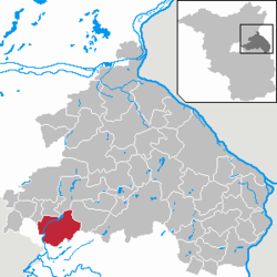 | |
 Rüdersdorf  Rüdersdorf | |
| Coordinates: 52°28′18″N 13°47′04″E | |
| Country | Germany |
| State | Brandenburg |
| District | Märkisch-Oderland |
| Subdivisions | 4 Ortsteile |
| Government | |
| • Mayor | Sabine Löser |
| Area | |
| • Total | 70.11 km2 (27.07 sq mi) |
| Elevation | 62 m (203 ft) |
| Population (2018-12-31)[1] | |
| • Total | 15,696 |
| • Density | 220/km2 (580/sq mi) |
| Time zone | CET/CEST (UTC+1/+2) |
| Postal codes | 15562 |
| Dialling codes | 033638 |
| Vehicle registration | MOL |
| Website | www.ruedersdorf.de |
It is served by the Schöneiche bei Berlin tramway which runs from Rüdersdorf through Schöneiche to Berlin-Friedrichshagen station on the Berlin S-Bahn network. Bundesautobahn 10 passes through the town.
Overview
The municipality is situated 26 km (16 mi) east of Berlin centre and includes the three districts Hennickendorf, Herzfelde and Lichtenow. Rüdersdorf is noted for its open-cast limestone mine. Today, some parts of the mine are used as a museum Museumspark Rüdersdorf. Notable buildings in Berlin such as the Brandenburg Gate and the Olympiastadium were built with limestone from Rüdersdorf.
Demography
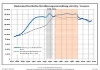 Development of Population since 1875 within the Current Boundaries (Blue Line: Population; Dotted Line: Comparison to Population Development of Brandenburg state; Grey Background: Time of Nazi rule; Red Background: Time of Communist rule)
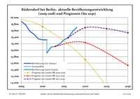 Recent Population Development and Projections (Population Development before Census 2011 (blue line); Recent Population Development according to the Census in Germany in 2011 (blue bordered line); Official projections for 2005-2030 (yellow line); for 2014-2030 (red line); for 2017-2030 (scarlet line)
| Rüdersdorf bei Berlin: Population development within the current boundaries (2013)[2] | |||||||||||||||||||||||||||||||||||||||||||||||||||||||||||||||||||||||||||||||||||||||||||||||||||||||||||||||||||||||||||||||||||||||||
|---|---|---|---|---|---|---|---|---|---|---|---|---|---|---|---|---|---|---|---|---|---|---|---|---|---|---|---|---|---|---|---|---|---|---|---|---|---|---|---|---|---|---|---|---|---|---|---|---|---|---|---|---|---|---|---|---|---|---|---|---|---|---|---|---|---|---|---|---|---|---|---|---|---|---|---|---|---|---|---|---|---|---|---|---|---|---|---|---|---|---|---|---|---|---|---|---|---|---|---|---|---|---|---|---|---|---|---|---|---|---|---|---|---|---|---|---|---|---|---|---|---|---|---|---|---|---|---|---|---|---|---|---|---|---|---|---|---|
|
|
| |||||||||||||||||||||||||||||||||||||||||||||||||||||||||||||||||||||||||||||||||||||||||||||||||||||||||||||||||||||||||||||||||||||||
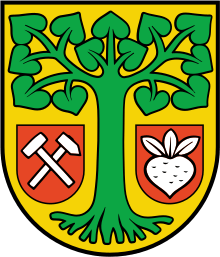
Coat of arms
The coat of arms of Gemeinde Rüdersdorf bei Berlin shows a rooted green lime tree with two red shields on its side. The shield towards the left of the trunk shows the silver hammer and pick as a symbol for the limestone quarrying: An industry which has shaped this municipality and is still present to this day. On the right side of the trunk, the shield symbolizes a silver turnip which represents the local agriculture. Both industries have been implanted back in the 13th century by the monks of the Zinna Abbey.[3]
Notable people
- Johanna Elberskirchen (1864-1943), activist
- Andreas Thom (born 1965), footballer
- Karla Woisnitza (born 1952), artist
- Giacomo Meyerbeer (1791-1864), opera composer
Partnerships with other communes
- Hemmoor in Lower Saxony, since 1991
- Pierrefitte-sur-Seine in France, since 1966
- Lomma Municipality in Sweden, since 2007
- Popielów in Poland, since 1997
References
- "Bevölkerung im Land Brandenburg nach amtsfreien Gemeinden, Ämtern und Gemeinden 31. Dezember 2018". Amt für Statistik Berlin-Brandenburg (in German). July 2019.
- Detailed data sources are to be found in the Wikimedia Commons. Population Projection Brandenburg at Wikimedia Commons
- "Rüdersdorf bei Berlin - Unsere Gemeinde". www.ruedersdorf.de. Retrieved 2017-08-10.
External links
![]()
| Authority control |
|
|---|