Rákosmente
Rákosmente is the 17th district of Budapest, being the easternmost district and being the district with the largest area (54.83 km2). Rákosmente was created by uniting four villages in 1950, and annexing them to Budapest. These villages were:
- Rákoskeresztúr
- Rákoscsaba
- Rákosliget
- Rákoshegy
17th District of Budapest Budapest XVII. kerülete Rákosmente | |
|---|---|
| District XVII | |
 Flag  Coat of arms | |
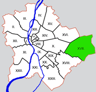
 Location of District XVII in Budapest (shown in grey) | |
| Coordinates: 47.4803°N 19.2667°E | |
| Country | Hungary |
| Region | Central Hungary |
| City | Budapest |
| Established | 1 January 1950 |
| Quarters[1] | List
|
| Government | |
| • Mayor | Tamás Horváth (Fidesz-KDNP) |
| Area | |
| • Total | 54.82 km2 (21.17 sq mi) |
| Area rank | 1st |
| Population (2016)[2] | |
| • Total | 87,793 |
| • Rank | 8th |
| • Density | 1,601/km2 (4,150/sq mi) |
| Demonym(s) | tizenhetedik kerületi ("17th districter") |
| Time zone | UTC+1 (CET) |
| • Summer (DST) | UTC+2 (CEST) |
| Postal code | 1171 ... 1174 |
| Website | www |
All these villages included the name of the little stream Rákos.
Neighbourhoods
The names of the neighbourhoods in Rákosmente come from the names of the original villages, adding the newly built neighbourhoods as well:
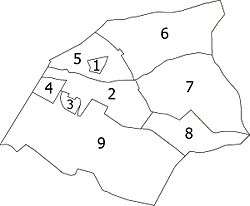
- Régiakadémiatelep (1930's)
- Rákoskeresztúr (13th century)
- Madárdomb (1984)
- Akadémiaújtelep (1950's)
- Rákosliget (1896)
- Rákoscsaba-Újtelep (1925)
- Rákoscsaba (11th century)
- Rákoskert (1933)
- Rákoshegy (1892)
Location
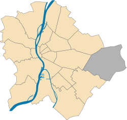
Rákosmente with its area of 54.83 km2, is more than 25 times larger than the smallest district; Erzsébetváros "Elisabethtown" (7th). Rákosmente is bordered by the 16th district to the northwest, by the 10th district to the west, by the 18th district to the southwest, by Ecser and Maglód to the southeast, by Pécel to the east and by Nagytarcsa to the northeast. The height from the sea level of some points of the district is same as the pitch of Gellért Hill.
Sport
The association football club, Rákosmenti KSK, is based in Rákosmente.
List of mayors
| Member | Party | Date | |
|---|---|---|---|
| József Dóczy | SZDSZ | 1990–1994 | |
| Péter Kátai | SZDSZ | 1994–1998 | |
| Katalin Devánszkiné Molnár | MSZP | 1998–2002 | |
| Attila Hoffmann | MSZP | 2002–2006 | |
| Levente Riz | Fidesz | 2006–2019[lower-alpha 1] | |
| Tamás Horváth | Fidesz | 2019– | |
Notes
- Died in office
References
- "94/2012. (XII. 27.) Főv. Kgy. rendelet - a közterület- és városrésznevek megállapításáról, azok jelöléséről, valamint a házszám-megállapítás szabályairól" (in Hungarian).
- "A fővárosi kerületek, a megyei jogú városok, a városok területe, lakónépessége és a lakások száma" [The area of districts of the capital, of the towns with county's rights, resident population and number of dwellings]. Magyarország közigazgatási helynévkönyve 2016. január 1 [Gazetteer of Hungary 1 January, 2016] (PDF). Hungarian Central Statistical Office. 2016. p. 21.
External links
| Wikimedia Commons has media related to Rákosmente. |
| Wikivoyage has a travel guide for East Pest. |
Districts of Budapest | ||
|---|---|---|
|  | |