Quelccaya Ice Cap
The Quelccaya (also known as Quenamari) Ice Cap is the second largest glaciated area in the tropics, after Coropuna. Located in the Cordillera Oriental section of the Andes mountains of Peru, the ice cap covers an area of 42.8 square kilometres (16.5 sq mi) with ice up to 200 metres (660 ft) thick. It is surrounded by tall ice cliffs and a number of outlet glaciers, the largest of which is known as Qori Kalis Glacier; the terrain surrounding the ice cap features lakes, moraines, peat bogs and wetlands and features a rich flora and fauna, including birds which have been observed to nest on the ice cap. Water from Quelccaya eventually nourishes the Inambari River and the Vilcanota River and is an important source of water.
| Quelccaya | |
|---|---|
| Quenamari | |
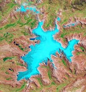 Outline of Quelccaya in 2010 | |
 | |
| Type | Ice cap |
| Coordinates | 13°55′S 70°49′W[1] |
| Status | Retreating |
A number of ice cores have been obtained from Quelccaya, including two ice cores in 1983 which are the first ice cores obtained outside of the polar regions. Past climate states, including evidence of the Little Ice Age, regional droughts and wet periods with historical significance and past and recent El Niño events, have been reconstructed from data in these ice cores. The ice cap is also regularly monitored and a weather station operates on it.
Quelccaya was much larger in the past, merging with neighbouring glaciers during the Pleistocene. A secondary expansion occurred during either the Antarctic Cold Reversal or the Younger Dryas; then with the beginning of the Holocene the ice cap shrank to a size smaller than today until about 6,000 - 5,000 years ago, when a Neoglacial expansion began. A number of moraines especially in the Huancané valley testify to past expansions and changes of Quelccaya, although the chronology of individual moraines is often unclear.
After reaching a secondary highstand during the Little Ice Age, Quelccaya has been shrinking concomitant with human-caused global warming; in particular the Qori Kalis Glacier has been retreating significantly. Life and lakes have been occupying the terrain left by retreating ice; these lakes can be dangerous as they can cause floods when they breach. Climate models predict that without aggressive climate change mitigation measures, Quelccaya is likely to disappear during the 21st-22nd century.
Geography
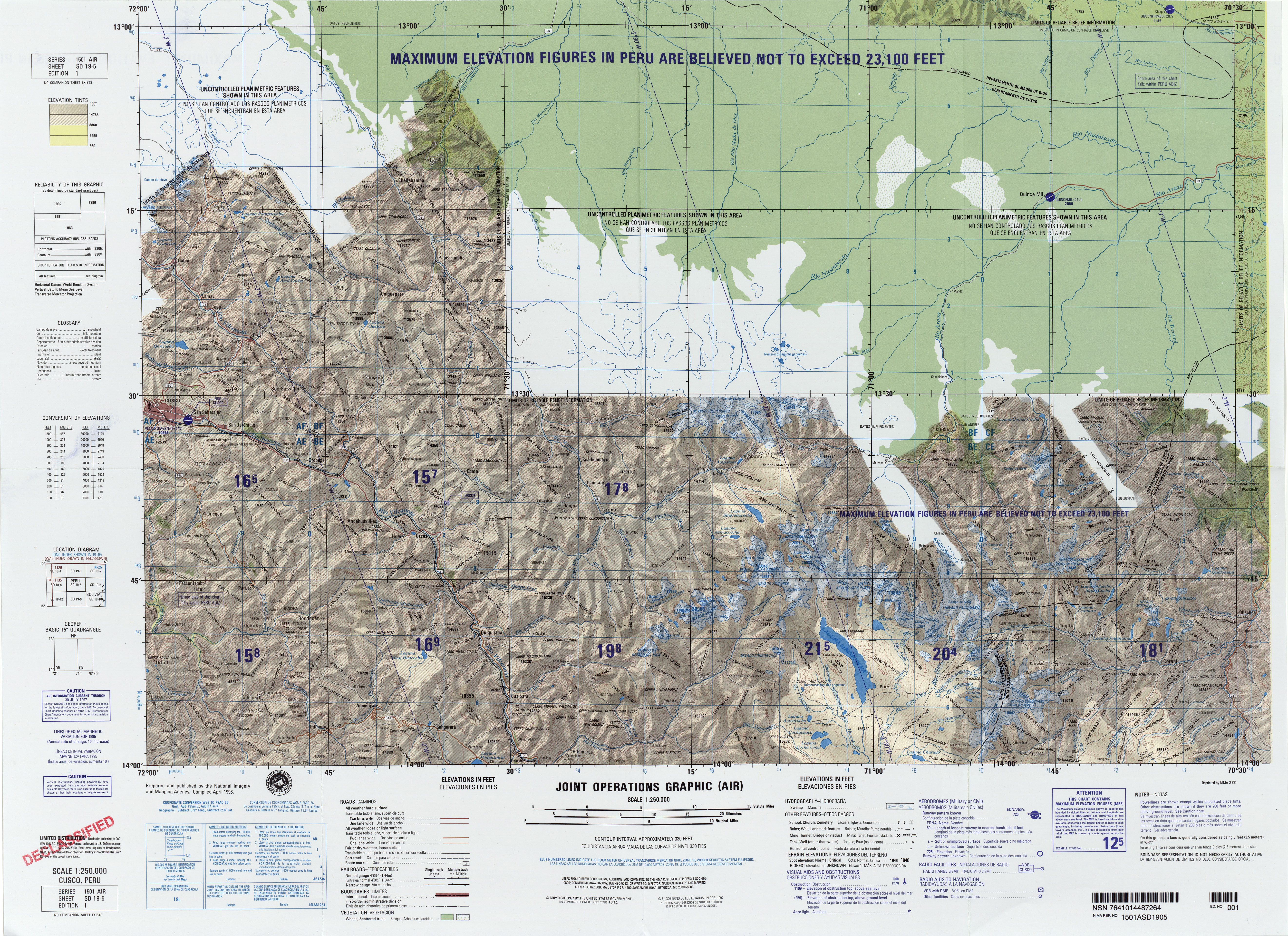
Quelccaya lies in the tropical highlands of southern Peru,[2] within the eastern Andes[3] in the Cordillera Oriental.[4] ten kilometres (6.2 mi)[5] northwest of Quelccaya lies the Cordillera Vilcanota mountain range,[3] which it is sometimes considered to be part of;[6] occasionally Quelccaya is also linked to the Cordillera Carabaya range.[7] East of Quelccaya, the Andes drop off steeply to the Amazon basin[8] and the Amazon rainforest is only 40 kilometres (25 mi) away; supposedly it can almost be seen from the summit of Quelccaya.[9] 120 kilometres (75 mi) south of Quelccaya lies Lake Titicaca.[10] Politically, Quelccaya is part of the Cuzco Department.[11]
The Andes in Peru, Ecuador and Bolivia are subdivided into several separate mountain ranges, many of which are glaciated above 5,000 metres (16,000 ft) elevation.[12] Peru contains about 70% of all tropical glaciers,[13] and Quelccaya together with ice bodies in New Guinea and the Rwenzori Mountains in Africa is one of the few tropical ice caps in the world,[14][15] or even the only one;[16] during glacial times there were more ice caps which may have resembled Quelccaya.[17] In 1968, the existence of two smaller ice caps south of Quelccaya was reported.[18]
Human geography
The ice cap, which is also known as Quenamari[19] and is sometimes also spelled Quelcaya,[20] lies in a remote area.[10] A road gets within 40 kilometres (25 mi) from the ice cap, which can be reached within three days with pack animals.[21] There are several camps at Quelccaya,[22] including one close to the northwestern ice margin.[23] A 1974 map shows a homestead on the Huancané River southwest from Quelccaya,[24] about 12 kilometres (7.5 mi) from the ice margin.[25] Quelccaya is part of the Quelccaya National Sanctuary, a protected area,[26] and the local population considers Quelccaya an important apu, a holy spirit.[27] The cities of Cuzco and Sicuani lie 130 kilometres (81 mi) northwest and 60 kilometres (37 mi) southwest of Quelccaya, respectively,[28][29] but the region around the ice cap is only thinly populated.[30]
The ice cap
Geography
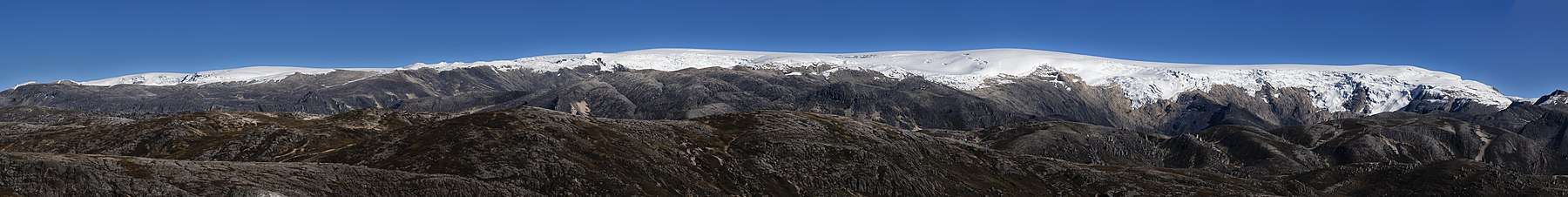
Quelccaya consists of an ice cap[lower-alpha 1] which extends up to 17 kilometres (11 mi) in north–south, 3–5 kilometres (1.9–3.1 mi) east–west direction[21] between 5,200–5,700 metres (17,100–18,700 ft) elevation;[32] it is thus a low-elevation ice cap by tropical standards[13] but Quelccaya still rises above its neighbourhood.[33] Unusually for glaciers the ice lies on a flat surface rather than on a mountain peak;[27] the highest summit in the area of the ice cap is known as Joyllor Puñuna and reaches 5,743 metres (18,842 ft) elevation.[5] Snowline elevation has been variously estimated at 5,250–5,300 metres (17,220–17,390 ft).[34]
The ice forms a relatively thin[35] and flat structure[22] with several ice domes, whose number is variously given as two,[35] three[24] or four;[36] the highest of which reaches 5,645 metres (18,520 ft) elevation.[36] Close to the summit the ice is 100–150 metres (330–490 ft) thick,[37] with a maximum thickness of about 200 metres (660 ft),[24] and a total volume of over 1 cubic kilometre (0.24 cu mi).[38] In terms of surface area, between 1975–2010, Quelccaya covered an area of 50.2 square kilometres (19.4 sq mi), decreasing over time;[13] by 2009 it had shrunk to 42.8 square kilometres (16.5 sq mi)[39][40] and was thus smaller than the ice on Coropuna[39] volcano also in southern Peru,[41] which is not declining as quickly.[42] Previously, Quelccaya was long considered the largest ice area of the tropics.[39]
The ice of the ice cap flows radially outward.[43] Spectacular[24] ice cliffs form most of the margin of Quelccaya,[10] they reach heights of 50 metres (160 ft) and often display banding[44] in the form of 0.5–1 metre (1 ft 8 in–3 ft 3 in) thick layers,[45] flutes or grooves and icicles.[46] Over interfluves, the border of the ice cap is embayed.[47] On the southern and western side parts of the ice cap[24] end at steep cliffs like they are found in polar regions.[48] From the ice falls,[24] short glaciers[36] up to 2 kilometres (1.2 mi) long[49] descend to elevations of 4,900–5,100 metres (16,100–16,700 ft), with lower elevations reached on the eastern side.[14] The largest of these glaciers is the Qori Kalis Glacier,[10] which extends from[2] the northern sector of Quelccaya westwards;[1] in general there is a contrast between lobe-like glaciers that emanate into the shallow valleys of the south-western side of Quelccaya and steeper glaciers with crevasses that descend into deeper valleys elsewhere around the ice cap.[50] On the southern side of the ice cap, the ice cap ends in four cirques with icefalls at their head and four sets of moraines downstream.[51] Melting at Quelccaya occurs at the bottom[52] and at the margins of the ice cap,[45] where meltwater is discharged.[53]
Physical structures of the ice
Conditions on the ice cap are polar,[18][54] and the ice surface has structures such as penitentes[lower-alpha 2][55] and sastrugi.[18] Penitentes occur especially at lower elevations on the ice cap;[55] at higher elevations they become smaller and eventually vanish, replaced with plate-shaped ice crystals with sizes of 0.5–1 centimetre (0.20–0.39 in). Towards the summit, the plates are replaced with column- or less commonly needle-shaped crystals, and eventually by dendritic crystals on the summit.[56] On the summit there are lenses of ice, probably from melting.[57]
Reconnaissance in 1974-1977 found glacier caves in the Quelccaya ice cap,[58] including elongated caves where the ice has overrun an obstacle thus creating an empty space,[14] and crevasse-associated caves[59] that form when they roof over.[60] Caves have fluted walls[14] and contain cave corals, flowstones, stalactites and stalagmites;[60] these speleothems are formed by ice.[61]
Physical-chemical traits of ice
The ice cap contains temperate ice[62][63][64] and in 2003 the ice had similar temperatures through its whole thickness[65] while according to a 1978 publication temperatures in the ice and its density increased with depth.[66][25] Temperatures of the glaciers at the base of Quelccaya reach the pressure melting point, except at some locations.[67] Radar data indicate the presence of water pockets in the ice.[63]
The ice of Quelccaya does not appear to have been particularly erosive during the late Holocene, as indicated by the preservation of plants underneath of it;[68] it is possible that the ice cap was in a temperate and erosive state when it was retreating such as during the early Holocene and cold-based and thus not very erosive during the expansion of the late Holocene.[69] Cold-based glaciers do not produce much meltwater and do not erode the ground they rest on as they fluctuate.[70]
Especially during the dry season, iron, silica and sodium accumulate on the ice cap in the form of microparticles, most of it originating in the Altiplano and possibly the sea.[71] Sulfate and nitrate are also found and may originate in the Amazon;[72] their concentrations at Quelccaya resemble these of snow in Andean regions.[73] Particles are coarser when they are deposited during the wet season, perhaps due to wet-season storms.[28] Diatoms,[74] insects, their bodyparts[75] and pollen have also been found in the ice.[76] The composition of the ice may be influenced by the precipitation type.[77]
During winter, the albedo of the ice is about 80%.[45] As reported in 2013,[78] 1979[44] and 1981, there is little energy available at the top of the Quelccaya ice cap as outgoing and incoming radiation are essentially balanced.[79][80] This radiation pattern, along with temperature and wind, influence the appearance of the surface of the Quelccaya ice.[81] Away from the ice cap, solar radiation is capable of quickly evaporating any snow.[82]
Geomorphology
The plateau that Quelccaya rises from features smooth bedrock[10][53] with a northeast to southwest slope[83] and is relatively flat, meaning that even a small rise of the freezing level will result in a large change in the ice.[1][84] The plateau is surrounded by an escarpment[15] and a number of valleys emanate from the plateau.[85]
On the western side of Quelccaya these valleys include the Qori Kalis valley northwest of the ice cap, Challpa Cocha valley south of Qori Kalis,[86] the 0.5 kilometres (0.31 mi) wide and flat Huancané and its tributary the "South Fork"[lower-alpha 3] valley[37] south of Challpa Cocha valley.[86] The Huancané valley runs southwestwards away from Quelccaya[87] and is occupied by the Huancané River.[88] Moraines from glaciers lie in the valleys radiating from the ice cap and contain alluvial deposits and peat bogs,[48] ponds[89] and wetlands within depressions.[90] Clay and peat are also found incorporated in moraines,[50] where peat has been exposed by erosion during floods.[91] Blocky boulders with sizes of up to 7 metres (23 ft) dot the valley floors.[37]
West of Quelccaya lies a high plain that is formed by glacial outwash and till.[36] The terrain features landforms such as drift deposits, lakes,[36] moraines and moraine-dammed lakes,[92] outwash fans,[93] peat bogs,[36] rocks bearing glacial striations,[69] streams[93] and wetlands.[94]
A number of lakes occur in the region of Quelccaya and the Cordillera Vilcanota, including Sibinacocha south of the Cordillera Vilcanota. Among the lakes close to the Quelccaya ice cap area:[95]
- Laguna Accocancha/[96]Aconcancha and Laguna Paco Cocha[97] upvalley from Aconcancha[98] both south of the Huancané valley.[97]
- Challpacocha lies west-southwest from Qori Kalis;[93] it is a tarn lake that receives meltwater from Quelccaya through several channels that flow through wetlands.[90]
- Churuyo lies southwest from Quelccaya.[96]
- Lado del Quelccaya, Lado del Quelccaya 2 and Laguna 5 due west.[95]
- North Lake, Base Camp Lake and Boulder Lake west of Quelccaya.[1] These three lakes lie at 5,100–5,200 metres (16,700–17,100 ft) elevation and formed within bedrock depressions when the glaciers retreated.[1]
- Pegador Pond west-northwest from the ice cap.[95]
- "Yanacocha" in the "South Fork" Valley[29] west of Quelccaya;[99] it is also a tarn lake[90] and developed in a formerly glaciated basin below an ignimbrite headwall. It currently forms a separate watershed from Quelccaya.[29]
Geology
Quelccaya lies on a plateau is formed by ignimbrites[36]/welded tuffs,[24] which are of rhyolitic composition[37] although the occurrence of andesite has also been reported.[100] The rocks were emplaced during the Miocene[37] 6 million years ago and only little erosion has taken place since then.[101] The volcanics may correlate with the Quenamari volcanics farther east.[102] West of Quelccaya a Holocene normal fault runs in north–south direction, part of the Ocongate fault system; this fault system extends across the Cordillera Vilcanota and has offset moraines, indicating it is active.
Climate
Annual precipitation at Quelccaya and the neighbouring Cordillera Vilcanota is about 0.8–1.0 metre per year (2.6–3.3 ft/a), with most of it originating from the Amazon and falling during austral summer[36] during the summer monsoon[106] when high insolation leads to intense convection and showers;[107] the location of the ice cap also generated orographic precipitation.[108] Most snowfall occurs during the passage of cold fronts[109] and cold air inclusions[110] and the net amount is a function of the duration of the wet season.[111] Overall, annually about 1,150 millimetres (45 in) of snow water equivalent accumulate on Quelccaya,[10] in the form of about 2–3 metres (6 ft 7 in–9 ft 10 in) snow[112] with rainfall sometimes occurring near its margins[107] and also near its summit.[113] This is much wetter than most of the tropical Andes, a consequence of Quelccaya's proximity to the Amazon.[37] This moisture originates from the Atlantic Ocean and is transported to Quelccaya by trade winds; a temperature inversion and blocking effects of coastal topography prevent moisture from the Pacific Ocean from reaching the ice cap.[1]
Unlike precipitation, temperatures are relatively stable throughout the year[10] with day-night temperature differences exceeding seasonal ones.[49] Temperatures at the top of Quelccaya are inferred to be about −4.2 °C (24.4 °F)[1]-−4.8 °C (23.4 °F)[36] Assuming a constant lapse rate mean temperatures of −3.3 °C (26.1 °F) (−6.3–0.9 °C (20.7–33.6 °F)) and −0.5 °C (31.1 °F) (2.9 – −3.1 °C (37.2–26.4 °F)) have been inferred for its margin during the dry and wet seasons, respectively.[1] As a consequence of global warming, temperatures on the summit of Quelccaya sometimes rise above freezing,[114] accelerating the shrinkage of the ice cap.[35]
Winds are strongest during the day[115] and mostly blow from the west, except during the rain season when they also come from the east or north-east.[116] The ice cap itself generates its own downslope katabatic wind, which blows over the ice and quickly peters out with distance from the ice margin.[117]
Climate variability
The climate is influenced by the El Niño-Southern Oscillation[29] and by the position of the Intertropical Convergence Zone;[118] during El Niño years precipitation is much less[29] as westerly winds suppress the transport of easterly moisture to Quelccaya.[106] During the strong 2014-16 El Niño event, there was actually a net decrease in snow height on Quelccaya.[119] Further, during El Niño there is a "front-loading" of precipitation with an earlier onset of the monsoon and decreased precipitation in its middle and late phase.[120] Temperatures are also modulated by El Niño events, during which an increase is observed[119] although winter temperatures decrease.[120]
Ice cores show evidence of past climate variability, such as increased precipitation between 1870–1984, 1500–1720, 760-1040 and with drought such as between 1720–1860, 1250–1310, 650–730, 570-610 and 540–560.[121] One of these wet periods has been correlated to the Medieval Climate Anomaly 1,000 – 700 years ago,[122] while drought periods have been linked to cultural changes in the Moche culture[123] and the collapse of Tiwanaku.[124] However, apart of precipitation fluctuations climate at Quelccaya has been stable over the past 1500 years[125] and precipitation has not fluctuated significantly over the past decades.[13]
Vegetation and animal life
The terrain west of Quelccaya is sparsely vegetated[29] with high elevation tundra vegetation.[126] The vegetation in the region is known as puna,[49] which is a kind of grassland;[127] above 4,300 metres (14,100 ft) elevation it is defined as "super-Puna", and consists of herb and shrubs such as Plantago and trees like Polylepis which grow to the ice cap and often have a krummholz appearance.[128] The only human use of the area is livestock grazing[29] but agriculture has also been reported.[129]
Aquatic plants are found in lakes.[90] The glacial runoff and precipitation guarantee an ample water supply, leading to the development of wetlands known as bofedales and peat;[37] Distichia muscoides is the dominant plant in the bofedales[90] and these wetlands are hotspots of biodiversity.[22] Tussock grasses have been expanding in the area.[130] Other plants include Festuca orthophylla, jarava ichu and nettles;[27] in total there are over fifty plant species.[129] Lichens grow on rocks;[126] 23 lichen species have been identified at Quelccaya.[129]
.jpg)
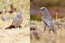
Among animals are 60 species of birds,[22] mammals in the surrounding region[131] such as Andean foxes, deers, wildcats, vicuñas and vizcachas,[27] while tadpoles[129] and water fleas occur in lakes.[90] Two birds,[132] the white-winged diuca finch[133] and the white-fronted ground tyrant are known to nest on the Quelccaya ice cap,[132] mostly within cavities in the ice that are barely accessible to humans.[132] The diuca finch is known to nest on ice elsewhere in the tropical Andes,[107] and other bird species might also nest on the Quelccaya ice.[130] Other than this finch, only emperor penguins are known to nest on ice; ice is an ill-suited environment for the raising of young birds[11] and Quelccaya presents additional challenges linked to its high elevation.[22] Other birds also nest in protected locations in the general Quelccaya area[134] and some species also roost on the ice.[135]
Scientific research and monitoring
Glaciers in the region have been monitored since the 1970s. Sediment cores in lakes and peat, soil formation and cosmogenic isotope dating have been used to infer past states of the ice cap,[2] and since 1976 Quelccaya is regularly reconnoitered.[136] An automated weather station that records various meteorological parametres was installed in 2003 and reinstalled in 2004 after vandalism,[137] and snow is sampled annually[106] although continuous precipitation records do not exist.[13] The American paleoclimatologist Lonnie Thompson and the Ohio State University have been monitoring Quelccaya since 1974[138] and the ice cap has been investigated for its glaciology[139] and for both its past and present climate.[22]
Ice cores
The layered appearance of the Quelccaya ice cap at its margins suggested to scientists that it could be used to obtain ice cores with annual resolution.[140] After a summer field program that lasted between 1976 and 1984,[141] in 1983 Lonnie Thompson and a team from the Ohio State University[142] obtained two 163.6 metres (537 ft) and 154.8 metres (508 ft) long ice cores[43][lower-alpha 4] from the central area of the Quelccaya ice cap.[23] The ice cores were drilled with the help of a solar-powered ice drill[43] specifically developed for the purpose of drilling into Quelccaya; it was developed because other power sources could not be brought onto the ice cap.[144] These ice cores were then investigated by the Byrd Polar Research Center also at Ohio State University[145] and cover a timespan of 1,500 and 1,350 years[43] with the longer ice core going back farther in time;[146] it goes back to 470 AD.[143] Another, shorter ice core measuring 15 metres (49 ft) length and spanning 8 years was obtained in 1976,[45] others followed in 1979, 1991, 1995, 2000,[136] 2003 and 2014.[147]
Dust layers deposited during the dry season[148] allow the determination of yearly layers,[43] which characteristically thin downward.[78] Additionally, volcanic ash deposited by the 1600 Huaynaputina eruption[149] has been used to date the ice core;[150] in turn the thickness of the ash at Quelccaya has been used to reconstruct the volume of the Huaynaputina eruption.[151]
A number of research findings have been made with the Quelccaya ice core:
- The ice cores contain annually resolved oxygen isotope ratio variations[70] which for the past millennium, the oxygen isotope ratios recorded at Quelccaya resemble these found in other tropical South American and also Tibetan ice cores.[152] While originally proposed to reflect temperature variations, the oxygen isotope ratios have also been assumed to reflect atmospheric circulation and temperatures in the Pacific Ocean[114] and tropical North Atlantic.[153]
- Oxygen isotope ratio variations record the Little Ice Age,[154] which clearly stands out in the Quelccaya ice core record;[155] the Quelccaya record has been used to infer that the Little Ice Age was a global event.[156] Quelccaya also shows evidence that temperature[154] and precipitation variations took place during the Little Ice Age; an early wet phase occurred between 1500 - 1720 and a late dry phase between 1720 - 1880;[157] and that at the ice cap it ended relatively suddenly around 1880.[158]
- The oxygen isotope ratios also vary during El Niño years;[120] the 1976 and the 1982-1983 El Niño events have been identified in the ice cores[159] and the ice cores have been employed to make a record of ENSO events.[73]
- A correlation between precipitation on the ice cap with water levels in Lake Titicaca[160] and traces of the severe drought between 1933 and 1945 have been found in the ice core record of Quelccaya.[161]
- Other climate events recorded at Quelccaya are the 1815 eruption of Mount Tambora[162] and the 536 climate downturn.[163]
- Snow accumulation has a roughly 250-year cyclicity; this may be a consequence of evaporation in the North Atlantic.[164] A 14-year cycle has also been detected.[165]
- Additional findings in the ice cores are dust clouds generated by earthquakes in the dry Atacama and Pacific coast of Peru,[166] dust correlated to droughts,[167] traces of the Suess cycle, a solar cycle,[168] evidence of Inka and Spanish industrial activity in South America,[169] and finally of agriculture around Lake Titicaca.[160]
The results of the Quelccaya ice core are widely used to reconstruct past climate states.[170] Quelccaya is the first ice cap from which old ice cores have been obtained that lies outside of the polar regions,[32][171] and the first annually resolved such record from the tropical Andes;[114] it demonstrated the usefulness of tropical ice for ice core studies[172] and has been called a "major step" in the sampling of high elevation ice in the world.[173] It was selected as a site for extra-polar ice core research as it is located in the sparsely investigated tropics and Quelccaya lies at higher elevation than Puncak Jaya in Indonesia or the Rwenzori Mountains in Africa; thus the ice is less disturbed by percolating meltwater.[44] Because of the lack of seasonal temperature variations and of synoptic weather patterns, tropical glaciers may primarily record secular climate change.[10]
Natural history of the ice cap
Moraines deposited by older glaciers indicate that during the Pleistocene and Holocene glaciers covered larger areas,[2] such as the outwash- and till-covered plain west of Quelccaya,[98] and connected with the Cordillera Vilcanota ice cap,[174][175] covering the area with sandy drift derived from ignimbrites.[88] During the maximum extent the ice reached down to elevations of 4,500 metres (14,800 ft) as the equilibrium line altitude decreased by 360 metres (1,180 ft);[175] this change in the equilibrium line altitude is considerably less than the decrease found elsewhere in the Peruvian Andes and may reflect topographical controls on glacier expansion.[176][177] The connection with the Vilcanota ice cap may have occurred during the last glacial maximum.[34]
No direct evidence of glacier expansions in times preceding marine isotope stage 4 remain[178] although an early glaciation of Quelccaya had ice advance to twice the distance it assumed during the Wisconsin glaciation.[14] Maximum extent occurred either about 20,000 years ago[176][177] or between 28,000 - 14,000 years ago. The maximum extent occurred during the Weichselian-Wisconsin glaciation[179] and within marine isotope stage 2.[180]
By 13,600 - 12,800 years ago Quelccaya had retreated concomitant with global glacier shrinkage at the end of the last glacial maximum. 12,500 years ago a readvance occurred, linked to a colder and wetter climate during the Younger Dryas. 12,400 years ago retreat recommenced and by 11,800-11,600 years ago the ice cap had reached a Little Ice Age-/modern-like extent.[181][182] Another proposed chronology indicates a glacier expansion between 13,300 years ago and ending by 12,900 years ago, with Quelccaya reaching a size not much larger than during the Holocene by 12,800 years ago.[183] A final scenario envisages an advance between 12,700 - 11,000 years ago.[184] There might have been two readvances, one in the early Younger Dryas and the other around 12,600 years ago.[185] A halt in retreat or an actual advance of Quelccaya may[186] or may not have occurred at the same time as Lake Tauca existed on the Altiplano, and it is possible that the retreat occurred during the middle Younger Dryas.[185]
Holocene
During the Holocene, Quelccaya did not expand farther than 1 kilometre (0.62 mi) from its present position[187] and early Holocene moraines have not been found.[188] It is possible that during the mid-Holocene Quelccaya was ice-free altogether,[189] peat deposits and ice cores indicate that it was reduced or even absent during that time.[190] Until either 7,000 years ago[191] or between at least 7,000 years ago and about 5,000 years ago, plants grew at its margins,[192] including cushion mire vegetation.[193] This shrinkage may relate to a warmer and drier climate at that time.[192]
5,000 years ago, the ice cap began to grow again at a time of global climate change, which included the drying of the Sahara at the end of the African humid period[194] and wetter and colder conditions in the extratropics.[195] This re-expansion was part of the global neoglacial;[196] this pattern of a larger ice cap during the late Holocene than the early is similar to that of Northern Hemisphere glaciers and may reflect Northern Hemisphere insolation.[69] The ice cap reached its Holocene maximum extent during the Little Ice Age.[197]
About 4,000 years ago, a new retreat occurred under the influence of warmer and drier climates,[198] and another shrinkage also occurred between 3,000 - 1,500 years ago.[199] Alternatively, 3,400 and 1,500 years before present the ice cap may have extended 1 kilometre (0.62 mi) past its current limit, and about 0.8 kilometres (0.50 mi) past its limit 1,600 years ago.[200]
Chronology at Huancané and Qori Kalis
Multiple moraines have been dated in the Huancané valley.[36] Three separate glacial stages have been identified here, H1, H2 and H3, with H3 being the longest glacier, H1 the shortest and H2 in between the two.[97] They have left moraines 8 kilometres (5.0 mi), 4 kilometres (2.5 mi) and 1 kilometre (0.62 mi) from the 2002 ice margin and are also known as Huancane I, Huancane II and Huancane III,[98] names which are sometimes applied to the glacial advances themselves.[201] The moraines in the valley are terminal moraines[34] and consist of sets of ridges up to 1 kilometre (0.62 mi) wide;[202] boulders found on the Huancane III moraines have fresher appearances than these on the other moraines.[88] Huancane III has also been subdivided into Huancane IIIa, IIIb and IIIc[92] and Huancane II into Huancane IIa, IIb and IIc.[37] These are all regressional moraines, as by the time of the emplacement of Huancane moraines, Quelccaya was shrinking[203] and was already disconnected from the ice on the Cordillera Vilcanota.[204] Finally, there is a set of moraines farther down the Huancané valley that appears to be the oldest.[205] Equivalents of the Huancane moraines have been identified outside of the Huancané valley.[35]
- Huancane III appears to be a last glacial maximum stand or a stand just after the last glacial maximum[206] such as Heinrich event 1[207] although its age is not well known.[37]
- Huancane II appear to have formed during a post-last glacial maximum advance.[206] One view sees Huancane II as preceding the Younger Dryas[208][209] and perhaps connected to the Antarctic Cold Reversal;[182] another one assumes that Quelccaya was smaller during the Antarctic Cold Reversal[181] and that Huancane II formed during the Younger Dryas,[37] and a final one that Huancane II was a localized glacier advance.[210]
- Huancane I moraines are less than 1,000 years old[211] and reflect the Little Ice Age extent of the Quelccaya ice cap[85] which at Quelccaya occurred between about 1490 and 1880[212] and partially also expansions that occurred 1,000, 600, 400 and 200 years ago.[91] Huancane I moraines are found all around Quelccaya,[190] and noticeable Little Ice Age moraines are also found in front of the outlet glaciers on the southeastern side of Quelccaya.[213]
About 16 late Holocene moraines are also found downstream of Qori Kalis glacier,[32] with the largest advance occurring before 520 ± 60 years ago, followed by a progressive retreat[211] and a readvance about 350 – 300 years ago. Similar glacier advance and retreat patterns have been observed in the Cordillera Blanca and Cordillera Vilcabamba in Peru, the Bolivian Andes and also in Patagonia and New Zealand and appear to reflect cold climate oscillations.[214]
Implications
In general, estimating the ages of moraines is difficult. A retreating glacier will deposit successive moraines but an advancing one can destroy older moraines less extensive than the glacier advance. Dates obtained from organic material behind a moraine may be considerably younger than the moraine as its development occurs with a lag from deglaciation, while organic matter in or underneath a moraine may be considerably older.[215] Changes in sediment fluxes to lakes west of Quelccaya appear to reflect advances and retreats of glaciers, with meltwater formed during retreats increasing sediment fluxes.[216]
The extent of the Quelccaya ice cap does not appear to correlate with the amount of precipitation occurring on the ice cap[211] except in particular cases;[214] temperature effects appear to dominate and warmer and wetter climates have been associated with retreat.[217][211] This dominance of temperature over precipitation in determining ice cap size and glacier length has been replicated by modelling.[218] Interannual climate variability does not have substantial effects on the extent of the ice cap.[219]
Present retreat

The glaciers are melting at increasing rates, with rapid deglaciation underway during the late 20th century[2] at a rate that is comparable to or exceeds that of postglacial retreat rates.[176] Between 1980 and 2010, the ice cap shrank at a rate of 0.57 ± 0.1 square kilometres per year (0.220 ± 0.039 sq mi/a)[220][221] with a loss of 30% of its area between 1979 and 2014.[222] Between 1990 and 2009, a southeastern branch of the ice cap disappeared altogether;[223] parts of the northwestern ice cap have separated from the main ice body[224] and by 2011 the retreat had reduced Quelccaya to a size it did not have since 6,000 years ago.[225] There is some variation between retreat rates measured by different researchers as the Quelccaya ice cap is differently defined[226] and due to differences between extents measured in seasons with and without snow cover.[224] True fluctuations also occur, such as an advance of part of Quelccaya's southern margin reported in 1977[17] which bulldozed peat deposits,[227] a pause of the Qori Kalis glacier between 1991-1993 probably linked with the global cooling caused by the Pinatubo eruption in 1991,[228] a slow-down in the mid-2000s and an overall higher rate of retreat since 2000.[229]
The Qori Kalis outlet glacier has been observed since 1963,[32] and between 1963 and 1978 retreated by about 6 metres per year (20 ft/a) and between 1991 and 2005 by about 60 metres per year (200 ft/a).[1] The retreat has been accompanied by a thinning[230] and volume loss of the ice cap, increasing from 290,000 cubic metres per year (10,000,000 cu ft/a) between 1963-1978 over 1,310,000 cubic metres per year (46,000,000 cu ft/a) between 1978-1983 to 2,200,000 cubic metres per year (78,000,000 cu ft/a) between 1983–1991.[2] The rate of retreat is higher than at the end of the last ice age[84] and the glacier responds quickly to climate alterations.[9]
This retreat has been observed at other tropical glaciers as well and is linked to increasing global temperatures[3] which are in turn caused by industrial greenhouse gas emissions.[4] This warming is unprecedented by the standards of the late Holocene.[231]
Consequences
Meltwater lakes[225] and proglacial lakes have formed in front of Qori Kalis glacier and other Quelccaya glaciers and expanded in size.[232][233] These lakes could be sources of future glacial lake outburst floods, although the sparse population of the area mitigates against this hazard;[234] one such flood occurred in March 2006 and drowned some alpaca.[235] In addition, some lakes have drained and the course of streams has changed from the glacier retreat.[236]
The freezing level regularly rises above the summit of Quelccaya,[237] and in recent ice cores, meltwater infiltration has become apparent,[238] to the point that oxygen isotope ratios are no longer preserved in the ice;[239] while this infiltration has smoothened the record only to a certain depth,[240][241] it illustrates the threat that climate change is creating for the existence of climate archives in ice cores.[242] Alpine life is quickly advancing into the terrain left by ice,[129] and the retreat has exposed plants that had been overrun during a glacier expansion that occurred 5,000 years ago.[195]
Future projections
Projected climate change is expected to involve a further 3–5 °C (5.4–9.0 °F) in the central Andes, with higher warming occurring at higher elevations.[220] In "business-as-usual" climate change scenarios, during the 21st century the equilibrium line altitude will rise above the top of the ice cap;[243] once the equilibrium line altitude has reached the top of the ice cap, the entire cap will become a zone of net ice loss[244] and Quelccaya will disappear. In scenarios that include aggressive mitigation measures, the ice cap may persist, while intermediate scenarios predict a loss of the ice cap in the 22nd century.[243] There is however some uncertainty owing to e.g. changes in precipitation,[245] such as a potential future decrease thereof.[246]
Hydrology and significance
Glacial meltwater is an important source of water especially in dry years and during the dry season,[3] including in the Altiplano and in the hyperarid coasts of Peru.[231] For example, about 80% of Peru's hydropower sources are buffered by glacial meltwater.[247] Avalanches and floods from glaciers have killed over 35,000 people[231] and glacial retreat will likely increase their incidence.[138] Enhanced melting may be contributing to streamflow, and past meltwater flows might have contributed to the formation of large lakes in the Altiplano.[3]
Most of Quelccaya borders on the Inambari River watershed, especially on the east and south; the western parts of the ice cap conversely border on the Vilcanota River/Urubamba River catchment[248][lower-alpha 5] of which it is an important part.[250] Clockwise the Rio Chimboya, the Quebrada Jetun Cucho, the Quebrada Queoñani, the Rio Quelcaya Mayu, an unnamed river, the Rio Huancané, the Rio Ritiananta and the Quebrada Accoaysana Pampa emanate from the ice cap. The first four rivers eventually converge into the westward flowing Rio Corani, a tributary of the[251] northward-flowing Rio Ollachea/Rio Sangabán which eventually ends into the Inambari River;[252] the last four rivers eventually converge into the southwards-flowing Rio Salcca,[251][253] which then turns west and ends into the Vilcanota River.[253] Some of the valleys that drain southeastward, northeastward and west-northwestward from Quelccaya can be affected by glacier-related floods.[254]
Quelccaya is the largest glacierized area in the watershed of the San Gabán hydropower plant[255] and also of the catchment Rio Vilcanota watershed;[250] its water is used by the Cusco Region.[138] The water is used for both irrigation and hydropower production. The population in the region is for the most part rural with low socioeconomic status, which makes it highly vulnerable to the effects of climate change.[246] Additionally, glaciers have important religious and social value for the local communities.[246]
Notes
- It has also been compared to a plateau glacier.[31]
- Inclined boards or sheets of snow.[55]
- Informal name;[37] Huancané is sometimes called North Fork Huancané.[86]
- Reaching the bedrock[143]
- Sometimes it is also stated that Lake Titicaca receives water from Quelccaya[249] but watershed maps show Quelccaya bordering on the Inambari River and Vilcanota River watershed, both of which drain to the Atlantic Ocean.[248]
References
- Buffen et al. 2009, p. 158.
- Mark et al. 2002, p. 287.
- Mark et al. 2002, p. 288.
- Buffen et al. 2009, p. 157.
- Smith et al. 2005, p. 159.
- Gade, Daniel W. (2016). Spell of the Urubamba. Cham: Springer International Publishing. p. 8. doi:10.1007/978-3-319-20849-7. ISBN 9783319208480.
- Jørgensen, Peter M.; Cano, Asunción; León, Blanca; Gonzáles, Paúl (2018). "Flora vascular y conexiones fitogeográficas de las montañas Carabaya, Perú". Revista Peruana de Biología. 25 (3): 191–210. doi:10.15381/rpb.v25i3.15228. ISSN 1727-9933.
- Hastenrath 1978, p. 86.
- Kargel et al. 2014, p. 612.
- Albert 2002, p. 211.
- Hardy & Hardy 2008, p. 613.
- Mark, Seltzer & Rodbell 2004, p. 151.
- Rabatel et al. 2018, p. 1.
- Thompson & McKenzie 1979, p. 16.
- M & Mercer 1977, p. 600.
- La Frenierre, Huh & Mark 2011, p. 775.
- Clapperton 1983, p. 90.
- Ricker 1968, p. 199.
- Sandeman et al. 1997, p. 224.
- Jong, R. de; Gunten, L. von; Maldonado, A.; Grosjean, M. (15 August 2013). "Late Holocene summer temperatures in the central Andes reconstructed from the sediments of high-elevation Laguna Chepical, Chile (32° S)". Climate of the Past. 9 (4): 1929. Bibcode:2013CliPa...9.1921D. doi:10.5194/cp-9-1921-2013. ISSN 1814-9324.
- Thompson 1980, p. 71.
- Hardy, Hardy & Gil 2019, p. 941.
- Thompson & Mosley-Thompson 1987, p. 100.
- Mercer et al. 1974, p. 20.
- Mercer et al. 1974, p. 22.
- INGEMMET 2003, Map17.
- "Nevado De Quelccaya". Recursos turísticos (in Spanish). Ministerio de Comercio Exterior y Turismo. Retrieved 13 September 2019.
- Arnao, Hastenrath & Thompson 1979, p. 1241.
- Beal et al. 2014, p. 439.
- INGEMMET 2003, Mapa2: Poblacion y Densidad.
- Kuhn 1981, p. 8.
- Howley et al. 2014, p. 347.
- Thompson et al. 1984, p. 4639.
- Smith et al. 2005, p. 160.
- Kelly et al. 2015, p. 72.
- Mark et al. 2002, p. 289.
- Phillips et al. 2016, p. 221.
- Drenkhan et al. 2019, p. 466.
- Kochtitzky et al. 2018, p. 179.
- Mosley‐Thompson & Thompson 2013, p. 15.
- Kochtitzky et al. 2018, p. 176.
- Kochtitzky et al. 2018, p. 182.
- Koci et al. 1985, p. 971.
- Arnao, Hastenrath & Thompson 1979, p. 1240.
- Thompson et al. 2016, p. 1.
- Hardy & Hardy 2008, p. 614.
- Kelly et al. 2015, pp. 71-72.
- Mercer et al. 1974, p. 21.
- Goodman et al. 2017, p. 31.
- M & Mercer 1977, p. 603.
- Ricker 1968, p. 198.
- Porter et al. 2017, p. 32.
- Jezek & Thompson 1982, p. 248.
- INGEMMET 2003, Mapa4: Clasificacion climatica.
- Koci & Hastenrath 1981, p. 424.
- Koci & Hastenrath 1981, p. 425.
- Seltzer 1990, p. 139.
- Thompson & McKenzie 1979, p. 15.
- Thompson & McKenzie 1979, p. 17.
- Thompson & McKenzie 1979, p. 19.
- Thompson & McKenzie 1979, p. 18.
- Clapperton 1983, p. 87.
- Jezek & Thompson 1982, p. 249.
- Thompson 1980, p. 73.
- Thompson, L. G.; Fontana, G. Dalla; Barbante, C.; Seppi, R.; Zagorodnov, V.; Davis, M.; Hausmann, H.; Krainer, K.; Dinale, R.; Gabrieli, J.; Carturan, L.; Gabrielli, P. (2010). "Atmospheric warming threatens the untapped glacial archive of Ortles mountain, South Tyrol". Journal of Glaciology. 56 (199): 851. Bibcode:2010JGlac..56..843G. doi:10.3189/002214310794457263. ISSN 0022-1430.
- Hastenrath 1978, p. 96.
- Malone et al. 2015, p. 113.
- Stroup et al. 2015, p. 836.
- Stroup, J. S.; Kelly, M. A.; Lowell, T. V.; Beal, S. A.; Smith, C. A. (December 2013). "Holocene fluctuations of Quelccaya Ice Cap, Peru based on lacustrine and surficial geologic archives". AGU Fall Meeting Abstracts. 2013: 31D–1890. Bibcode:2013AGUFMPP31D1890S.
- Stroup et al. 2015, p. 830.
- Allen et al. 1985, p. 85.
- Allen et al. 1985, p. 87.
- Davies, Tranter & Jones 1991, p. 374.
- Fritz, Sherilyn C.; Brinson, Bruce E.; Billups, W. E.; Thompson, Lonnie G. (1 May 2015). "Diatoms at >5000 Meters in the Quelccaya Summit Dome Glacier, Peru". Arctic, Antarctic, and Alpine Research. 47 (2): 373. doi:10.1657/AAAR0014-075. ISSN 1523-0430.
- Reese & Liu 2002, p. 53.
- Reese & Liu 2002, p. 51.
- Kuhn 1981, p. 9.
- Thompson & Mosley‐Thompson 2013, p. 16.
- Koci & Hastenrath 1981, p. 426.
- Koci et al. 1985, p. 972.
- Koci & Hastenrath 1981, p. 427.
- Kelly et al. 2015, p. 77.
- Kelly et al. 2015, p. 71.
- Mark, Bryan G.; Seltzer, Geoffrey O. (2005), Huber, Uli M.; Bugmann, Harald K. M.; Reasoner, Mel A. (eds.), "Glacier Recession in the Peruvian Andes: Climatic Forcing, Hydrologic Impact and Comparative Rates Over Time", Global Change and Mountain Regions, Springer Netherlands, 23, p. 6, doi:10.1007/1-4020-3508-x_21, ISBN 9781402035074, retrieved 13 September 2019 – via ResearchGate
- Malone et al. 2015, p. 107.
- Malone et al. 2015, p. 108.
- Mark, Seltzer & Rodbell 2004, p. 155.
- M & Mercer 1977, p. 602.
- Phillips et al. 2016, p. 223.
- Stroup et al. 2015, p. 833.
- Stroup, J. S.; Kelly, M. A.; Lowell, T. (2009). "Little Ice Age Fluctuations of Quelccaya Ice Cap, Peru". AGU Fall Meeting Abstracts. 2009: 31A–1300. Bibcode:2009AGUFMPP31A1300S.
- Kelly et al. 2015, p. 73.
- Stroup et al. 2015, p. 831.
- Hudson et al. 2012, p. 991.
- Michelutti, Neal; Tapia, Pedro M.; Labaj, Andrew L.; Grooms, Christopher; Wang, Xiaowa; Smol, John P. (16 July 2019). "A limnological assessment of the diverse waterscape in the Cordillera Vilcanota, Peruvian Andes". Inland Waters. 0 (3): 2. doi:10.1080/20442041.2019.1582959. ISSN 2044-2041.
- Goodman et al. 2017, p. 34.
- Mark et al. 2002, p. 291.
- Mark et al. 2002, p. 293.
- Beal et al. 2014, p. 438.
- Uglietti, Chiara; Gabrielli, Paolo; Olesik, John W.; Lutton, Anthony; Thompson, Lonnie G. (1 August 2014). "Large variability of trace element mass fractions determined by ICP-SFMS in ice core samples from worldwide high altitude glaciers". Applied Geochemistry. 47: 110. Bibcode:2014ApGC...47..109U. doi:10.1016/j.apgeochem.2014.05.019. ISSN 0883-2927.
- Ehlers, Todd A.; Lease, Richard O. (16 August 2013). "Incision into the Eastern Andean Plateau During Pliocene Cooling". Science. 341 (6147): 774–6. Bibcode:2013Sci...341..774L. doi:10.1126/science.1239132. ISSN 0036-8075. PMID 23950534.
- Sandeman et al. 1997, p. 225.
- Hurley et al. 2015, p. 7468.
- Hardy & Hardy 2008, p. 616.
- Leffler, Robert J. (May 2005). "Is the meltdown of tropical glaciers a signal of climate change?: Going, Going, Gone". Weatherwise. 58 (3): 40. doi:10.3200/WEWI.58.3.36-43.
- Hurley et al. 2015, p. 7483.
- Sulca, Juan; Vuille, Mathias; Roundy, Paul; Takahashi, Ken; Espinoza, Jhan-Carlo; Silva, Yamina; Trasmonte, Grace; Zubieta, Ricardo (2018). "Climatology of extreme cold events in the central Peruvian Andes during austral summer: origin, types and teleconnections". Quarterly Journal of the Royal Meteorological Society. 144 (717): 2696. Bibcode:2018QJRMS.144.2693S. doi:10.1002/qj.3398. ISSN 1477-870X.
- Hurley et al. 2015, p. 7484.
- Reese & Liu 2002, p. 45.
- Endries, Jason L.; Perry, L. Baker; Yuter, Sandra E.; Seimon, Anton; Andrade-Flores, Marcos; Winkelmann, Ronald; Quispe, Nelson; Rado, Maxwell; Montoya, Nilton; Velarde, Fernando; Arias, Sandro (July 2018). "Radar-Observed Characteristics of Precipitation in the Tropical High Andes of Southern Peru and Bolivia". Journal of Applied Meteorology and Climatology. 57 (7): 1453. Bibcode:2018JApMC..57.1441E. doi:10.1175/JAMC-D-17-0248.1.
- Hurley et al. 2015, p. 7467.
- Thompson et al. 1984, p. 4640.
- Reese & Liu 2002, p. 47.
- Reese & Liu 2002, p. 52.
- Goodman et al. 2017, p. 32.
- Hurley, Vuille & Hardy 2019, p. 132.
- Hurley, Vuille & Hardy 2019, p. 141.
- Koci et al. 1985, p. 973.
- Bush, M. B.; Correa-Metrio, A.; McMichael, C. H.; Sully, S.; Shadik, C. R.; Valencia, B. G.; Guilderson, T.; Steinitz-Kannan, M.; Overpeck, J. T. (1 June 2016). "A 6900-year history of landscape modification by humans in lowland Amazonia". Quaternary Science Reviews. 141: 59. Bibcode:2016QSRv..141...52B. doi:10.1016/j.quascirev.2016.03.022. ISSN 0277-3791.
- Shimada et al. 1991, p. 262.
- Weiss, Harvey (30 November 2017). Weiss, Harvey (ed.). Megadrought, Collapse, and Causality. Oxford University Press. p. 5. doi:10.1093/oso/9780199329199.001.0001. ISBN 9780190607920.
- Eash, N. S.; Sandor, J. A. (1 February 1995). "Soil chronosequence and geomorphology in a semi-arid valley in the Andes of southern Peru". Geoderma. 65 (1): 62. Bibcode:1995Geode..65...59E. doi:10.1016/0016-7061(94)00025-6. ISSN 0016-7061.
- Phillips et al. 2016, p. 229.
- Reese, Carl A.; Liu, Kam-biu (1 May 2005). "Interannual Variability in Pollen Dispersal and Deposition on the Tropical Quelccaya Ice Cap". The Professional Geographer. 57 (2): 187. doi:10.1111/j.0033-0124.2005.00471.x. ISSN 0033-0124.
- Reese & Liu 2002, p. 46.
- Krajick, Kevin (12 March 2004). "All Downhill From Here?". Science. 303 (5664): 1600–2. doi:10.1126/science.303.5664.1600. ISSN 0036-8075. PMID 15016975.
- Hardy, Hardy & Gil 2019, p. 954.
- Thompson 1980, p. 70.
- Hardy, Hardy & Gil 2019, p. 947.
- Hardy & Hardy 2008, p. 615.
- Hardy, Hardy & Gil 2019, p. 952.
- Hardy, Hardy & Gil 2019, p. 949.
- Diaz 2003, p. 150.
- Hurley et al. 2015, p. 7469.
- Bookhagen & Hanshaw 2014, p. 360.
- Hardy, Hardy & Gil 2019, p. 940.
- Thompson, Mosley-Thompson & Henderson 2000, p. 377.
- Thompson & Mosley-Thompson 1987, p. 99.
- DeWayne Cecil, Green & Thompson 2004, p. xviii.
- Diaz 2003, p. 147.
- Zagorski, N. (25 July 2006). "Profile of Lonnie G. Thompson". Proceedings of the National Academy of Sciences. 103 (31): 11437–9. Bibcode:2006PNAS..10311437Z. doi:10.1073/pnas.0605347103. ISSN 0027-8424. PMC 1544187. PMID 16868075.
- Shimada et al. 1991, p. 261.
- Thompson & Mosley-Thompson 1987, p. 101.
- Thompson et al. 2016, p. 2.
- Grootes et al. 1986, p. 361.
- Grootes et al. 1986, p. 362.
- Davies, Tranter & Jones 1991, p. 367.
- Adams, Nancy K.; de Silva, Shanaka L.; Self, Stephen; Salas, Guido; Schubring, Steven; Permenter, Jason L.; Arbesman, Kendra (1 April 2001). "The physical volcanology of the 1600 eruption of Huaynaputina, southern Peru". Bulletin of Volcanology. 62 (8): 508. Bibcode:2001BVol...62..493A. doi:10.1007/s004450000105. ISSN 1432-0819.
- DeWayne Cecil, Green & Thompson 2004, p. 9.
- Wiersma, A. P.; Renssen, H. (1 January 2006). "Model–data comparison for the 8.2kaBP event: confirmation of a forcing mechanism by catastrophic drainage of Laurentide Lakes". Quaternary Science Reviews. 25 (1): 81. Bibcode:2006QSRv...25...63W. doi:10.1016/j.quascirev.2005.07.009. ISSN 0277-3791.
- Grootes et al. 1986, p. 363.
- Thompson & Mosley‐Thompson 2013, p. 17.
- Grootes et al. 1986, p. 364.
- Heine 2019, p. 315.
- Mosley‐Thompson & Thompson 2013, p. 30.
- Sandweiss, Daniel H. (1986). "The beach ridges at Santa, Peru: El Niño, uplift, and prehistory". Geoarchaeology. 1 (1): 27. doi:10.1002/gea.3340010103. ISSN 1520-6548.
- Seltzer 1990, p. 151.
- Thompson & Mosley-Thompson 1987, p. 105.
- Clapperton, Chalmers M. (1993). "Glacier readvances in the Andes at 12 500–10 000 YR BP: Implications for mechanism of Late-glacial climatic change". Journal of Quaternary Science. 8 (3): 213. Bibcode:1993JQS.....8..197C. doi:10.1002/jqs.3390080303. ISSN 1099-1417.
- Newfield, Timothy P. (2018), "The Climate Downturn of 536–50", in White, Sam; Pfister, Christian; Mauelshagen, Franz (eds.), The Palgrave Handbook of Climate History, Palgrave Macmillan UK, p. 459, doi:10.1057/978-1-137-43020-5_32, ISBN 9781137430199
- Villalba, Ricardo; Boninsegna, José A.; Lara, Antonio; Veblen, Tom T.; Roig, Fidel A.; Aravena, Juan-Carlos; Ripalta, Alberto (1996), Jones, Philip D.; Bradley, Raymond S.; Jouzel, Jean (eds.), "Interdecadal climatic variations in millennial temperature reconstructions from southern South America", Climatic Variations and Forcing Mechanisms of the Last 2000 Years, Springer Berlin Heidelberg, p. 185, doi:10.1007/978-3-642-61113-1_9, ISBN 978-3-642-64700-0
- Soubiès, F.; Seidel, A.; Mangin, A.; Genty, D.; Ronchail, J.; Plagnes, V.; Hirooka, S.; Santos, R. (1 June 2005). "A fifty-year climatic signal in three Holocene stalagmite records from Mato Grosso, Brazil". Quaternary International. 135 (1): 124. doi:10.1016/j.quaint.2004.10.027. ISSN 1040-6182.
- Seimon 2003, p. 3.
- Haberle, Simon G.; David, Bruno (1 January 2004). "Climates of change: human dimensions of Holocene environmental change in low latitudes of the PEPII transect". Quaternary International. 118-119: 176. doi:10.1016/S1040-6182(03)00136-8. ISSN 1040-6182.
- Pollock, AL; van Beynen, PE; DeLong, KL; Polyak, V; Asmerom, Y; Reeder, PP (1 December 2016). "A mid-Holocene paleoprecipitation record from Belize". Palaeogeography, Palaeoclimatology, Palaeoecology. 463: 109. Bibcode:2016PPP...463..103P. doi:10.1016/j.palaeo.2016.09.021. ISSN 0031-0182.
- Uglietti, C.; Gabrielli, P.; Thompson, L. G. (December 2013). "Detailed history of atmospheric trace elements from the Quelccaya ice core (Southern Peru) during the last 1200 years". AGU Fall Meeting Abstracts. 2013: 51A–1907. Bibcode:2013AGUFMPP51A1907U.
- Seimon 2003, p. 1.
- Thompson 2000, p. 26.
- Thompson, Mosley-Thompson & Henderson 2000, p. 378.
- Scatena, Frederick N.; Wehmiller, John F. (1 July 2015). "2012 Benjamin Franklin Medal in Earth and Environmental Science presented to Ellen Mosley-Thompson and Lonnie G. Thompson". Journal of the Franklin Institute. 352 (7): 2550. doi:10.1016/j.jfranklin.2015.02.014. ISSN 0016-0032.
- La Frenierre, Huh & Mark 2011, p. 779.
- Mark et al. 2002, p. 295.
- Mark et al. 2002, p. 297.
- Mark, Seltzer & Rodbell 2004, p. 154.
- Goodman et al. 2017, p. 46.
- M & Mercer 1977, pp. 603-604.
- Goodman et al. 2017, p. 47.
- Hudson et al. 2012, p. 993.
- Heine 2019, p. 262.
- La Frenierre, Huh & Mark 2011, p. 794.
- Kelly, M. A.; Lowell, T. V.; Schaefer, J. M.; Finkel, R. C. (2008). "Late-glacial and Holocene history of changes in Quelccaya Ice Cap, Peru". AGU Fall Meeting Abstracts. 2008: GC12A–03. Bibcode:2008AGUFMGC12A..03K.
- Kelly, M. A.; Lowell, T. V.; Applegate, P. J.; Smith, C.; Phillips, F. M.; Hudson, A. M. (2011). "Quelccaya Ice Cap extents during the last glacial-interglacial transition: evidence for rapid climate changes in the southern tropics during Younger Dryas time". AGU Fall Meeting Abstracts. 2011: 13E–06. Bibcode:2011AGUFMPP13E..06K.
- Alcalá-Reygosa, Jesús; Palacios, David; Vázquez-Selem, Lorenzo (25 August 2017). "A preliminary investigation of the timing of the local last glacial maximum and deglaciation on HualcaHualca volcano - Patapampa Altiplano (arid Central Andes, Peru)". Quaternary International. 449: 149. Bibcode:2017QuInt.449..149A. doi:10.1016/j.quaint.2017.07.036. ISSN 1040-6182.
- Seltzer, Geoffrey O.; Rodbell, Donald T. (2005). "Delta progradation and Neoglaciation, Laguna Parón, Cordillera Blanca, Peru". Journal of Quaternary Science. 20 (7–8): 715. Bibcode:2005JQS....20..715S. doi:10.1002/jqs.975. ISSN 1099-1417.
- Heine 2019, p. 298.
- Mark, Seltzer & Rodbell 2004, p. 158.
- Mark et al. 2002, p. 294.
- Beal et al. 2014, p. 445.
- Buffen et al. 2009, p. 160.
- Birks, H. John B.; Birks, Hilary H. (January 2016). "How have studies of ancient DNA from sediments contributed to the reconstruction of Quaternary floras?". New Phytologist. 209 (2): 501. doi:10.1111/nph.13657. PMID 26402315.
- Buffen et al. 2009, p. 161.
- Buffen et al. 2009, p. 162.
- Stansell et al. 2013, p. 9.
- La Frenierre, Huh & Mark 2011, p. 798.
- Stansell et al. 2013, p. 10.
- Solomina, Olga N.; Bradley, Raymond S.; Hodgson, Dominic A.; Ivy-Ochs, Susan; Jomelli, Vincent; Mackintosh, Andrew N.; Nesje, Atle; Owen, Lewis A.; Wanner, Heinz; Wiles, Gregory C.; Young, Nicolas E. (1 March 2015). "Holocene glacier fluctuations". Quaternary Science Reviews. 111: 18. doi:10.1016/j.quascirev.2014.11.018. ISSN 0277-3791.
- Lowell, T. V.; Smith, C. A.; Kelly, M. A.; Stroup, J. S. (2012). "Holocene Activity of the Quelccaya Ice Cap: A Working Model". AGU Fall Meeting Abstracts. 2012: GC24B–02. Bibcode:2012AGUFMGC24B..02L.
- La Frenierre, Huh & Mark 2011, p. 787.
- Mercer et al. 1974, p. 23.
- Heine 1993, p. 776.
- Clapperton 1983, p. 136.
- Goodman et al. 2017, p. 35.
- Hudson et al. 2012, p. 992.
- Baranes, H. E.; Kelly, M. A.; Stroup, J. S.; Howley, J. A.; Lowell, T. V. (December 2012). "Surface Exposure Dating of the Huancané III Moraines in Peru: A Record of Quelccaya Ice Cap's Maximum Extent during the Last Glacial Period". AGU Fall Meeting Abstracts. 2012: GC21D–0992. Bibcode:2012AGUFMGC21D0992B.
- Heine 1993, p. 777.
- La Frenierre, Huh & Mark 2011, p. 801.
- Borrero, Luis Alberto (1 January 1999). "Human dispersal and climatic conditions during Late Pleistocene times in Fuego-Patagonia". Quaternary International. 53-54: 95. Bibcode:1999QuInt..53...93B. doi:10.1016/S1040-6182(98)00010-X. ISSN 1040-6182.
- Howley et al. 2014, p. 348.
- Calkin, Parker E.; Young, Grant M. (1 January 2002), Menzies, John (ed.), "2 - Global glacial chronologies and causes of glaciation", Modern and Past Glacial Environments, Butterworth-Heinemann, p. 39, ISBN 9780750642262, retrieved 10 September 2019
- Huggel et al. 2003, p. 28.
- Howley et al. 2014, p. 349.
- Mark et al. 2002, p. 296.
- Stroup et al. 2015, p. 838.
- Hudson et al. 2012, p. 994.
- Malone et al. 2015, p. 112.
- Malone et al. 2015, pp. 111-112.
- Rabatel et al. 2018, p. 2.
- Bookhagen & Hanshaw 2014, p. 365.
- Kargel et al. 2014, p. 609.
- Kargel et al. 2014, p. 615.
- Bookhagen & Hanshaw 2014, p. 369.
- Lin, P.-N.; Mikhalenko, V. N.; Howat, I. M.; Zagorodnov, V. S.; Davis, M. E.; Mosley-Thompson, E.; Thompson, L. G. (24 May 2013). "Annually Resolved Ice Core Records of Tropical Climate Variability over the Past ~1800 Years". Science. 340 (6135): 945–50. Bibcode:2013Sci...340..945T. doi:10.1126/science.1234210. ISSN 0036-8075. PMID 23558172.
- Bookhagen & Hanshaw 2014, p. 368.
- Seltzer 1990, p. 147.
- Diaz 2003, p. 151.
- Bookhagen & Hanshaw 2014, p. 366.
- Thompson et al. 2016, p. 14.
- Albert 2002, p. 210.
- Bookhagen & Hanshaw 2014, pp. 368-369.
- Drenkhan et al. 2018, p. 112.
- Drenkhan et al. 2019, p. 478.
- Brecher et al. 2017, p. 32.
- Brecher et al. 2017, p. 31.
- Thompson, L. G.; Mosley-Thompson, E.; Davis, M. E.; Beaudon, E.; Lin, P. N. (December 2016). "A Perspective on the Unprecedented Impact of the 2015/16 El Niño on the Tropical Quelccaya Ice Cap, Peru from Four Decades of Surface Sampling and Deep Drilling". AGU Fall Meeting Abstracts. 2016: 53D–01. Bibcode:2016AGUFMPP53D..01T.
- Thompson et al. 2016, p. 4.
- Thompson 2000, p. 32.
- Heine 2019, p. 105.
- Brecher et al. 2017, p. 26.
- Thompson 2000, p. 33.
- Malone, A.; Lowell, T. V.; Stroup, J. S. (2018). "The Potential for Total Loss of the World's Largest Tropical Ice Mass (Quelccaya Ice Cap, Peru)". AGU Fall Meeting Abstracts. 2018: C43C–1807. Bibcode:2018AGUFM.C43C1807M.
- Rabatel et al. 2018, p. 6.
- Rabatel et al. 2018, p. 9.
- Drenkhan et al. 2018, p. 106.
- Bookhagen & Hanshaw 2014, pp. 359-360.
- INGEMMET 2003, Map05.
- Porter et al. 2017, p. 35.
- Drenkhan et al. 2018, p. 107.
- "Cusco, Peru" (Map). Joint Operations Graphic (1 ed.). 1:250,000. National Imagery and Mapping Agency. 1996.
- "Lanlacuni Bajo, Peru; Bolivia" (Map). Joint Operations Graphic (1 ed.). 1:250,000. National Imagery and Mapping Agency. 1995.
- "Sicuani, Peru" (Map). Joint Operations Graphic. 1:250,000. National Imagery and Mapping Agencyedition =1. 1996.
- INGEMMET 2003, Mapa12: Area flujos de huaycos.
- Huggel et al. 2003, p. 24.
Sources
- Albert, Todd H. (1 July 2002). "Evaluation of Remote Sensing Techniques for Ice-Area Classification Applied to the Tropical Quelccaya Ice Cap, Peru". Polar Geography. 26 (3): 210–226. doi:10.1080/789610193. ISSN 1088-937X.
- Allen, Boyd; Thompson, Lonnie G.; Mayewski, A. Paul; Lyons, W. Berry (1985). "The Glaciochemistry of Snow-Pits from Quelccaya Ice Cap, Peru, 1982". Annals of Glaciology. 7: 84–88. Bibcode:1985AnGla...7...84L. doi:10.3189/S0260305500005954. ISSN 0260-3055.
- Arnao, Benjamín Morales; Hastenrath, Stefan; Thompson, Lonnie G. (23 March 1979). "Climatic Ice Core Records from the Tropical Quelccaya Ice Cap". Science. 203 (4386): 1240–1243. Bibcode:1979Sci...203.1240T. doi:10.1126/science.203.4386.1240. ISSN 0036-8075. PMID 17841138.
- Beal, Samuel A.; Kelly, Meredith A.; Stroup, Justin S.; Jackson, Brian P.; Lowell, Thomas V.; Tapia, Pedro M. (2014). "Natural and anthropogenic variations in atmospheric mercury deposition during the Holocene near Quelccaya Ice Cap, Peru". Global Biogeochemical Cycles. 28 (4): 437–450. Bibcode:2014GBioC..28..437B. doi:10.1002/2013GB004780. ISSN 1944-9224. PMC 6370314. PMID 30760944.
- Benavente Escobar, Carlos Lenin; Delgado Madera, Gabino Fabrizio; Taipe Maquerhua, Edu Luis; Audin, Laurence; Pari Pinto, Walter (2013). "Neotectónica y peligro sísmico en la región Cusco [Boletín C 55]". INGEMMET (in Spanish). Retrieved 12 September 2019.
- Bookhagen, B.; Hanshaw, M. N. (3 March 2014). "Glacial areas, lake areas, and snow lines from 1975 to 2012: status of the Cordillera Vilcanota, including the Quelccaya Ice Cap, northern central Andes, Peru". The Cryosphere. 8 (2): 359–376. Bibcode:2014TCry....8..359H. doi:10.5194/tc-8-359-2014. ISSN 1994-0416.
- Brecher, Henry H.; Davis, Mary E.; Mosley-Thompson, Ellen; Thompson, Lonnie G. (2017). "Tropical glaciers, recorders and indicators of climate change, are disappearing globally". Annals of Glaciology. 52 (59): 23–34. doi:10.3189/172756411799096231. ISSN 0260-3055.
- Buffen, Aron M.; Thompson, Lonnie G.; Mosley-Thompson, Ellen; Huh, Kyung In (1 September 2009). "Recently exposed vegetation reveals Holocene changes in the extent of the Quelccaya Ice Cap, Peru". Quaternary Research. 72 (2): 157–163. Bibcode:2009QuRes..72..157B. doi:10.1016/j.yqres.2009.02.007. ISSN 0033-5894.
- Clapperton, C. M. (1 January 1983). "The glaciation of the Andes". Quaternary Science Reviews. 2 (2–3): 83–155. Bibcode:1983QSRv....2...83C. doi:10.1016/0277-3791(83)90005-7. ISSN 0277-3791.
- Davies, T. D.; Tranter, M.; Jones, H. G., eds. (1991). Seasonal Snowpacks: Processes of Compositional Change. Berlin, Heidelberg: Springer Berlin Heidelberg. doi:10.1007/978-3-642-75112-7. ISBN 9783642751141.
- DeWayne Cecil, L.; Green, Jaromy R.; Thompson, Lonnie G., eds. (2004). Earth Paleoenvironments: Records Preserved in Mid- and Low-Latitude Glaciers. Developments in Paleoenvironmental Research. 9. Dordrecht: Kluwer Academic Publishers. doi:10.1007/1-4020-2146-1. ISBN 9781402021459.
- Diaz, Henry F., ed. (2003). Climate Variability and Change in High Elevation Regions: Past, Present & Future. Advances in Global Change Research. 15. Dordrecht: Springer Netherlands. doi:10.1007/978-94-015-1252-7. ISBN 9789048163229.
- Drenkhan, Fabian; Guardamino, Lucía; Huggel, Christian; Frey, Holger (1 October 2018). "Current and future glacier and lake assessment in the deglaciating Vilcanota-Urubamba basin, Peruvian Andes" (PDF). Global and Planetary Change. 169: 105–118. Bibcode:2018GPC...169..105D. doi:10.1016/j.gloplacha.2018.07.005. ISSN 0921-8181.
- Drenkhan, Fabian; Huggel, Christian; Guardamino, Lucía; Haeberli, Wilfried (15 May 2019). "Managing risks and future options from new lakes in the deglaciating Andes of Peru: The example of the Vilcanota-Urubamba basin". Science of the Total Environment. 665: 465–483. Bibcode:2019ScTEn.665..465D. doi:10.1016/j.scitotenv.2019.02.070. ISSN 0048-9697. PMID 30772577.
- Goodman, Adam Y.; Rodbell, Donald T.; Seltzer, Geoffrey O.; Mark, Bryan G. (20 January 2017). "Subdivision of Glacial Deposits in Southeastern Peru Based on Pedogenic Development and Radiometric Ages". Quaternary Research. 56 (1): 31–50. doi:10.1006/qres.2001.2221 – via ResearchGate.
- Grootes, P. M.; Dansgaard, W.; Mosley-Thompson, E.; Thompson, L. G. (17 October 1986). "The Little Ice Age as Recorded in the Stratigraphy of the Tropical Quelccaya Ice Cap". Science. 234 (4774): 361–364. Bibcode:1986Sci...234..361T. doi:10.1126/science.234.4774.361. ISSN 0036-8075. PMID 17834534.
- Hardy, Spencer P.; Hardy, Douglas R. (2008). "White-winged Diuca Finch (Diuca speculifera) Nesting on Quelccaya Ice Cap, Perú". The Wilson Journal of Ornithology. 120 (3): 613–617. doi:10.1676/06-165.1. ISSN 1559-4491.
- Hardy, Spencer P.; Hardy, Douglas R.; Gil, Koky Castañeda (17 January 2019). "Avian nesting and roosting on glaciers at high elevation, Cordillera Vilcanota, Peru". The Wilson Journal of Ornithology. doi:10.1676/17-00029.1 (inactive 2020-03-22).
- Hastenrath, Stefan (1978). "Heat-Budget Measurements on the Quelccaya Ice Cap, Peruvian Andes *". Journal of Glaciology. 20 (82): 85–97. doi:10.3189/S0022143000021237. ISSN 0022-1430.
- Heine, Jan T. (1 January 1993). "A reevaluation of the evidence for a Younger Dryas climatic reversal in the tropical Andes". Quaternary Science Reviews. 12 (9): 769–779. Bibcode:1993QSRv...12..769H. doi:10.1016/0277-3791(93)90016-F. ISSN 0277-3791.
- Heine, Klaus (2019). Das Quartär in den Tropen: Eine Rekonstruktion des Paläoklimas (in German). Berlin, Heidelberg: Springer Berlin Heidelberg. doi:10.1007/978-3-662-57384-6. ISBN 9783662573839.
- Howley, Jennifer A.; Applegate, Patrick J.; Lowell, Thomas V.; Kelly, Meredith A.; Stroup, Justin S. (1 April 2014). "Late Holocene fluctuations of Qori Kalis outlet glacier, Quelccaya Ice Cap, Peruvian Andes". Geology. 42 (4): 347–350. Bibcode:2014Geo....42..347S. doi:10.1130/G35245.1. ISSN 0091-7613.
- Hudson, Adam M.; Phillips, Fred M.; Smith, Colby A.; Applegate, Patrick J.; Lowell, Thomas V.; Kelly, Meredith A. (1 November 2012). "Late glacial fluctuations of Quelccaya Ice Cap, southeastern Peru". Geology. 40 (11): 991–994. Bibcode:2012Geo....40..991K. doi:10.1130/G33430.1. ISSN 0091-7613.
- Huggel, C.; Haeberli, W.; Kääb, A.; Ayros, E.; Portocarrero, C. (2003). Assessment of glacier hazards and glacier runoff for different climate scenarios based on remote sensing data: a case study for a hydropower plant in the Peruvian Andes. EARSeL Workshop, Observing our cryosphere from space. Bern – via ResearchGate.
- Hurley, John V.; Vuille, Mathias; Hardy, Douglas R.; Burns, Stephen J.; Thompson, Lonnie G. (2015). "Cold air incursions, δ18O variability, and monsoon dynamics associated with snow days at Quelccaya Ice Cap, Peru". Journal of Geophysical Research: Atmospheres. 120 (15): 7467–7487. Bibcode:2015JGRD..120.7467H. doi:10.1002/2015JD023323. ISSN 2169-8996.
- Hurley, J. V.; Vuille, Mathias; Hardy, Douglas R. (2019). "On the Interpretation of the ENSO Signal Embedded in the Stable Isotopic Composition of Quelccaya Ice Cap, Peru". Journal of Geophysical Research: Atmospheres. 124 (1): 131–145. Bibcode:2019JGRD..124..131H. doi:10.1029/2018JD029064. ISSN 2169-8996.
- INGEMMET (2003). "Estudio de riesgos geológicos del Perú: Franja N° 3 - [Boletín C 28]". Instituto Geológico, Minero y Metalúrgico - Ingemmet (in Spanish).
- Jezek, K. C.; Thompson, L. G. (July 1982). "Interpretation of Mono-Pulse Ice Radar Soundings on Two Peruvian Glaciers" (PDF). IEEE Transactions on Geoscience and Remote Sensing. GE-20 (3): 243–249. Bibcode:1982ITGRS..20..243J. doi:10.1109/TGRS.1982.350437.
- Kargel, Jeffrey S.; Leonard, Gregory J.; Bishop, Michael P.; Kääb, Andreas; Raup, Bruce H., eds. (2014). Global Land Ice Measurements from Space. Berlin, Heidelberg: Springer Berlin Heidelberg. doi:10.1007/978-3-540-79818-7. hdl:2060/20040111284. ISBN 9783540798170.
- Kelly, Meredith A.; Lowell, Thomas V.; Applegate, Patrick J.; Phillips, Fred M.; Schaefer, Joerg M.; Smith, Colby A.; Kim, Hanul; Leonard, Katherine C.; Hudson, Adam M. (1 February 2015). "A locally calibrated, late glacial 10Be production rate from a low-latitude, high-altitude site in the Peruvian Andes". Quaternary Geochronology. 26: 70–85. doi:10.1016/j.quageo.2013.10.007. ISSN 1871-1014.
- Kochtitzky, William H.; Edwards, Benjamin R.; Enderlin, Ellyn M.; Marino, Jersy; Marinque, Nelida (2018). "Improved estimates of glacier change rates at Nevado Coropuna Ice Cap, Peru". Journal of Glaciology. 64 (244): 175–184. Bibcode:2018JGlac..64..175K. doi:10.1017/jog.2018.2. ISSN 0022-1430.
- Koci, Bruce; Hastenrath, Stefan (1981). "Micro-Morphology of the Snow Surface at the Quelccaya Ice Cap, Peru". Journal of Glaciology. 27 (97): 423–428. Bibcode:1981JGlac..27..423H. doi:10.3189/S002214300001145X. ISSN 0022-1430.
- Koci, B. R.; Bolzan, J. F.; Mosley-Thompson, E.; Thompson, L. G. (6 September 1985). "A 1500-Year Record of Tropical Precipitation in Ice Cores from the Quelccaya Ice Cap, Peru". Science. 229 (4717): 971–973. Bibcode:1985Sci...229..971T. doi:10.1126/science.229.4717.971. ISSN 0036-8075. PMID 17782530.
- Kuhn, M. (1981). "Vergletscherung, Nullgradgrenze und Niederschlag in den Anden". 76.–78. Jahresbericht des Sonnblick-Vereines für die Jahre 1978–1980. Jahresberichte des Sonnblick-Vereines (in German). Springer Vienna. 1978-80: 3–13. doi:10.1007/978-3-7091-4407-7_1. ISBN 978-3-211-81662-2.
- La Frenierre, Jeff; Huh, Kyung In; Mark, Bryan G. (1 January 2011), Ehlers, Jürgen; Gibbard, Philip L.; Hughes, Philip D. (eds.), "Chapter 56 - Ecuador, Peru and Bolivia", Developments in Quaternary Sciences, Quaternary Glaciations - Extent and Chronology, Elsevier, 15: 773–802, doi:10.1016/B978-0-444-53447-7.00056-8, retrieved 10 September 2019
- M, Oscar Palacios; Mercer, J. H. (1 October 1977). "Radiocarbon dating of the last glaciation in Peru". Geology. 5 (10): 600–604. Bibcode:1977Geo.....5..600M. doi:10.1130/0091-7613(1977)5<600:RDOTLG>2.0.CO;2. ISSN 0091-7613.
- Malone, Andrew G. O.; Pierrehumbert, Raymond T.; Lowell, Thomas V.; Kelly, Meredith A.; Stroup, Justin S. (1 October 2015). "Constraints on southern hemisphere tropical climate change during the Little Ice Age and Younger Dryas based on glacier modeling of the Quelccaya Ice Cap, Peru". Quaternary Science Reviews. 125: 106–116. Bibcode:2015QSRv..125..106M. doi:10.1016/j.quascirev.2015.08.001. ISSN 0277-3791.
- Mark, Bryan G; Seltzer, Geoffrey O; Rodbell, Donald T; Goodman, Adam Y (1 May 2002). "Rates of Deglaciation during the Last Glaciation and Holocene in the Cordillera Vilcanota-Quelccaya Ice Cap Region, Southeastern Perú". Quaternary Research. 57 (3): 287–298. Bibcode:2002QuRes..57..287M. doi:10.1006/qres.2002.2320. ISSN 0033-5894.
- Mark, Bryan G.; Seltzer, Geoffrey O.; Rodbell, Donald T. (1 January 2004), "Late Quaternary glaciations of Ecuador, Peru and Bolivia", in Ehlers, J.; Gibbard, P. L. (eds.), Quaternary Glaciations Extent and Chronology - Part III: South America, Asia, Africa, Australasia, Antarctica, Developments in Quaternary Sciences, 2, Elsevier, pp. 151–163, doi:10.1016/S1571-0866(04)80120-9, ISBN 9780444515933
- Mercer, J. H.; Thompson, L. G.; Maranguníc, C.; Ricker, J. (1974). "Peru's Quelccaya Ice Cap: Glaciological and Glacial Geological Studies". Antarctic Journal of the United States. 10 (1): 24–26. ISSN 0003-5335.
- Mosley‐Thompson, E.; Thompson, L. G. (23 March 2013). "One‐Half Millennia of Tropical Climate Variability as Recorded in the Stratigraphy of the Quelccaya Ice Cap, Peru". Aspects of Climate Variability in the Pacific and the Western Americas. Geophysical Monograph Series. American Geophysical Union (AGU): 15–31. doi:10.1029/gm055p0015. ISBN 9781118664285.
- Phillips, Fred M.; Kelly, Meredith A.; Hudson, Adam M.; Stone, John O. H.; Schaefer, Joerg; Marrero, Shasta M.; Fifield, L. Keith; Finkel, Robert; Lowell, Thomas (1 February 2016). "CRONUS-Earth calibration samples from the Huancané II moraines, Quelccaya Ice Cap, Peru". Quaternary Geochronology. 31: 220–236. doi:10.1016/j.quageo.2015.10.005. ISSN 1871-1014.
- Porter, Stacy E.; Davis, Mary E.; Mosley-Thompson, Ellen; Thompson, Lonnie G. (1 December 2017). "Ice Core Records of Climate and Environmental Variability in the Tropical Andes of Peru: Past, Present and Future". Revista de Glaciares y Ecosistemas de Montaña (3): 16. ISSN 2519-7649.
- Rabatel, Antoine; Ramos, Hugo; Cruz, Jorge De la; Timm, Oliver Elison; Hardy, Douglas R.; Vuille, Mathias; Yarleque, Christian (22 October 2018). "Projections of the future disappearance of the Quelccaya Ice Cap in the Central Andes". Scientific Reports. 8 (1): 15564. Bibcode:2018NatSR...815564Y. doi:10.1038/s41598-018-33698-z. ISSN 2045-2322. PMC 6197230. PMID 30349015.
- Reese, Carl A.; Liu, Kam-biu (1 January 2002). "Pollen Dispersal and Deposition on the Quelccaya Ice Cap, Peru". Physical Geography. 23 (1): 44–58. doi:10.2747/0272-3646.23.1.44. ISSN 0272-3646.
- Ricker, John (1968). "The Southern Vilcanota". The American Alpine Journal.
- Sandeman, Hamish A.; Clark, Alan H.; Farrar, Edward; Pauca, Guido Arroyo (1 May 1997). "Lithostratigraphy, petrology and 40Ar-39Ar geochronology of the Crucero Supergroup, Puno department, SE Peru". Journal of South American Earth Sciences. 10 (3): 223–245. Bibcode:1997JSAES..10..223S. doi:10.1016/S0895-9811(97)00023-0. ISSN 0895-9811.
- Seimon, Anton (2003). "Improving climatic signal representation in tropical ice cores: A case study from the Quelccaya Ice Cap, Peru". Geophysical Research Letters. 30 (14): 1772. Bibcode:2003GeoRL..30.1772S. doi:10.1029/2003GL017191. ISSN 1944-8007.
- Shimada, Izumi; Schaaf, Crystal Barker; Thompson, Lonnie G.; Mosley-Thompson, Ellen (1991). "Cultural Impacts of Severe Droughts in the Prehistoric Andes: Application of a 1,500-Year Ice Core Precipitation Record". World Archaeology. 22 (3): 247–270. doi:10.1080/00438243.1991.9980145. ISSN 0043-8243. JSTOR 124787.
- Seltzer, Geoffry O. (1 January 1990). "Recent glacial history and paleoclimate of the Peruvian-Bolivian Andes". Quaternary Science Reviews. 9 (2): 137–152. Bibcode:1990QSRv....9..137S. doi:10.1016/0277-3791(90)90015-3. ISSN 0277-3791.
- Smith, Jacqueline A.; Seltzer, Geoffrey O.; Rodbell, Donald T.; Klein, Andrew G. (1 September 2005). "Regional synthesis of last glacial maximum snowlines in the tropical Andes, South America". Quaternary International. 138-139: 145–167. Bibcode:2005QuInt.138..145S. doi:10.1016/j.quaint.2005.02.011. ISSN 1040-6182.
- Stansell, Nathan D.; Rodbell, Donald T.; Abbott, Mark B.; Mark, Bryan G. (15 June 2013). "Proglacial lake sediment records of Holocene climate change in the western Cordillera of Peru". Quaternary Science Reviews. 70: 1–14. Bibcode:2013QSRv...70....1S. doi:10.1016/j.quascirev.2013.03.003. ISSN 0277-3791.
- Stroup, Justin S.; Kelly, Meredith A.; Lowell, Thomas V.; Smith, Colby A.; Beal, Samuel A.; Landis, Joshua D.; Tapia, Pedro M. (2015). "Late Holocene fluctuations of Quelccaya Ice Cap, Peru, registered by nearby lake sediments". Journal of Quaternary Science. 30 (8): 830–840. Bibcode:2015JQS....30..830S. doi:10.1002/jqs.2821. ISSN 1099-1417.
- Thompson, Lonnie G.; McKenzie, Garry D. (January 1979). "Origin of Glacier Caves in the Quelccaya Ice Cap, Peru" (PDF). The NSS Bulletin. National Speleological Society. 41 (1): 11–14. ISSN 1090-6924.
- Thompson, Lonnie G. (1980). "Glaciological Investigations of the Tropical Quelccaya Ice Cap, Peru*". Journal of Glaciology. 25 (91): 69–84. doi:10.3189/S0022143000010297. ISSN 0022-1430.
- Thompson, L. G.; Mosley-Thompson, E.; Grootes, P. M.; Pourchet, M.; Hastenrath, S. (1984). "Tropical glaciers: Potential for ice core paleoclimatic reconstructions". Journal of Geophysical Research. 89 (D3): 4638. Bibcode:1984JGR....89.4638T. doi:10.1029/JD089iD03p04638.
- Thompson, Lonnie G.; Mosley-Thompson, Ellen (1987), Berger, W. H.; Labeyrie, L. D. (eds.), "Evidence of Abrupt Climatic Change During the Last 1,500 Years Recorded in Ice Cores from the Tropical Quelccaya Ice Cap, Peru", Abrupt Climatic Change, Springer Netherlands, pp. 99–110, doi:10.1007/978-94-009-3993-6_9, ISBN 9789401082723
- Thompson, Lonnie G. (1 January 2000). "Ice core evidence for climate change in the Tropics: implications for our future". Quaternary Science Reviews. 19 (1): 19–35. Bibcode:2000QSRv...19...19T. doi:10.1016/S0277-3791(99)00052-9. ISSN 0277-3791.
- Thompson, Lonnie G.; Mosley-Thompson, Ellen; Henderson, Keith A. (May 2000). "Ice-core palaeoclimate records in tropical South America since the Last Glacial Maximum". Journal of Quaternary Science. 15 (4): 377–394. Bibcode:2000JQS....15..377T. doi:10.1002/1099-1417(200005)15:4<377::AID-JQS542>3.0.CO;2-L.
- Thompson, L. G.; Mosley‐Thompson, E. (2013). "One-Half Millennia of Tropical Climate Variability as Recorded in the Stratigraphy of the Quelccaya Ice Cap, Peru". Aspects of Climate Variability in the Pacific and the Western Americas. Geophysical Monograph Series. American Geophysical Union (AGU): 15–31. doi:10.1029/gm055p0015. ISBN 9781118664285.
- Thompson, L. G.; Brecher, H. H.; Braun, C.; Hardy, D. R.; Chadwell, C. D. (9 March 2016). "Thinning of the Quelccaya Ice Cap over the last thirty years". The Cryosphere Discussions: 1–18. doi:10.5194/tc-2016-40. ISSN 1994-0416.