Freezing level
The freezing level, or 0 °C (zero-degree) isotherm, represents the altitude in which the temperature is at 0 °C (the freezing point of water) in a free atmosphere (i.e. allowing reflection of the sun by snow, etc.). Any given measure is valid for only a short period of time, often less than a day.

Above the freezing altitude, the temperature of the air is below freezing. Below it, the temperature is above freezing. The profile of this frontier, and its variations, are studied in meteorology, and are used for a variety of forecasts and predictions. Whilst not given on general weather forecasts, it is used on bulletins giving forecasts for mountainous areas.
Measuring
There are several different methods to examine the structure of the temperature of the atmosphere:
- A radiosonde attached to a weather balloon is the oldest and most common method used. Each area releases two balloons a day in locations hundreds of kilometres apart.
- Measuring devices attached to commercial airliners permit reporting the isotherm, and its height, to aerial traffic.
- Weather satellites are equipped with sensors which scan the atmosphere and measure the infrared radiation it emits.
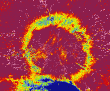
- Weather radar detects bright bands, which are radar echoes produced just underneath the isotherm caused by the melting of snow in the layer above 0 °C.
- A wind profiler, an upward pointing radar, can detect the speed of precipitation, which is different for rain, snow, and melting snow.
Depending on the frequency and resolution at which these readings are taken, these methods can report the isotherm with greater or lesser precision. Radiosondes, for example, only report a reading twice daily and provide very rough information. Weather radar can detect a variation every five to ten minutes if there is precipitation, and can scan a radius of up to two kilometres.
Variations in the isotherm
The isotherm can be very stable over a large area. It varies under two conditions:
- A change in the density of air due to weather fronts. This changes the isotherm gradually, over tens of kilometres for a cold front, and hundreds for a warm front.
- Local levels can be changed by wind, reflection of the sun, snow, and humidity level. These factors can cause the isotherm to change rapidly over several kilometres, in both winter and summer. Also, atmospheric subsidence and ascendence can contribute to variations in the isotherm.
These conditions imply that the 0 °C isotherm varies globally.
See also
- Temperature inversion
- Lapse rate
References
- The Mountain Manual, Seuil, 2000