Queen Mary Falls
The Queen Mary Falls is a plunge waterfall on the Spring Creek that is located in the Darling Downs region of Queensland, Australia.
| Queen Mary Falls | |
|---|---|
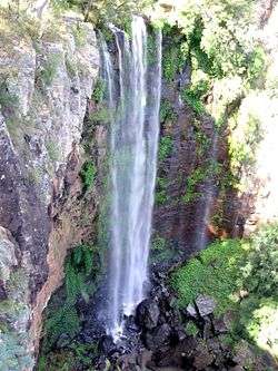 Queen Mary Falls, pictured in 2006. | |
 | |
| Location | Darling Downs, Queensland, Australia |
| Coordinates | 28°20′24″S 152°22′21″E[1][2] |
| Type | Plunge |
| Total height | 40 metres (130 ft)[3] |
| Number of drops | 1 |
| Longest drop | 40 metres (130 ft)[3] |
| Watercourse | Spring Creek |
Location and features
The falls are situated in the Main Range National Park and descend 40 metres (130 ft)[3] from the McPherson Range near the Queensland/New South Wales border. They are located 50 kilometres (31 mi) south-east of Warwick and 10 kilometres (6.2 mi) east of the town of Killarney.
The falls formed when water erosion by streams created gorges through layers of basalt and resistant trachyte.[4] The falls are currently retreating as large blocks at the bottom of the falls were not evident in photos taken in the 19th century.[5] Facilities at the falls include toilets, tables and fireplaces.
Four other waterfalls are located in the area surrounding Killarney, including the Teviot Falls, Daggs Falls, Browns Falls and Upper Browns Falls.
References
- "Queen Mary Falls (QLD)". Gazetteer of Australia online. Geoscience Australia, Australian Government.
- "Queen Mary Falls (entry 27792)". Queensland Place Names. Queensland Government. Retrieved 13 September 2015.
- "Queen Mary Falls". World of Waterfalls. Johnny T. Cheng. 9 May 2008. Retrieved 18 May 2014.
- Queen Mary Falls National Park Visitor information. 1993. Queensland Department of Environment and Heritage.
- Stevens, Neville; Willmott, Warwick (1996). The Main Range. Geological Society of Australia (Queensland Division).
External links
![]()
- Queen Mary Falls Circuit
- "Queen Mary Falls circuit". About Main Range National Park. Queensland Government (Department of National Parks, Recreation, Sport and Racing). 2014.