Quebrada de Humahuaca
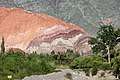
The Quebrada de Humahuaca is a narrow mountain valley located in the province of Jujuy in northwest Argentina, 1,649 km (1,025 mi) north of Buenos Aires (23°11′59″S 65°20′56″W). It is about 155 km (96 mi) long, oriented north-south, bordered by the Altiplano in the west and north, by the Sub-Andean hills in the east, and by the warm valleys (Valles Templados) in the south.
| UNESCO World Heritage Site | |
|---|---|
 View of the Quebrada de Humahuaca | |
| Location | Jujuy Province, Argentina |
| Criteria | Cultural: (ii), (iv), (v) |
| Reference | 1116 |
| Inscription | 2003 (27th session) |
| Area | 172,116.4375 ha (425,308.979 acres) |
| Buffer zone | 369,648.8125 ha (913,422.108 acres) |
| Coordinates | 23°11′59″S 65°20′56″W |
 Location of Quebrada de Humahuaca in Argentina | |
The name quebrada (literally "broken") translates as a deep valley or ravine. It receives its name from Humahuaca, a small city of 11,000 inhabitants. The Grande River (Río Grande), which is dry in winter, flows copiously through the Quebrada in the summer.
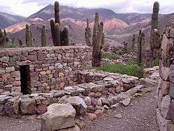
The region has always been a crossroads for economic, social and cultural communication. It has been populated for at least 10,000 years, since the settlement of the first hunter-gatherers, which is evidenced by substantial prehistoric remains. It was a caravan road for the Inca Empire in the 15th century, then an important link between the Viceroyalty of the Río de la Plata and the Viceroyalty of Peru, as well as a stage for many battles of the Spanish War of Independence.
The Quebrada de Humahuaca was made a UNESCO World Heritage Site on 2 July 2003.

See also
References
External links
- UNESCO World Heritage Centre - Description of the site.
- Jujuy Province - Official website (in Spanish).
- Municipal information: Municipal Affairs Federal Institute (IFAM), Municipal Affairs Secretariat, Ministry of Interior, Argentina. (in Spanish)
- Pictures from Humahuaca
| Northwest | ||
|---|---|---|
| Mesopotamia |
| |
| Cuyo | ||
| Pampas | ||
| Patagonia |
| |