QGIS
QGIS (until 2013 known as Quantum GIS[2]) is a free and open-source cross-platform desktop geographic information system (GIS) application that supports viewing, editing, and analysis of geospatial data.[3]
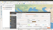 QGIS 2.2 showing the redesigned menus. | |
| Developer(s) | QGIS Development Team |
|---|---|
| Initial release | July 2002 |
| Stable release | 3.12.0 "București" (February 21, 2020[1]) [±] |
| Preview release | None [±] |
| Repository | |
| Written in | C++, Python, Qt |
| Platform | Windows, Linux, Mac OS X, Android(beta) |
| Available in | Multilingual |
| Type | Geographic information system |
| License | GNU GPLv2 |
| Website | qgis |
Functionality
QGIS functions as geographic information system (GIS) software, allowing users to analyze and edit spatial information, in addition to composing and exporting graphical maps.[3] QGIS supports both raster and vector layers; vector data is stored as either point, line, or polygon features. Multiple formats of raster images are supported, and the software can georeference images.
QGIS supports shapefiles, coverages, personal geodatabases, dxf, MapInfo, PostGIS, and other formats.[4] Web services, including Web Map Service and Web Feature Service, are also supported to allow use of data from external sources.[5]
QGIS integrates with other open-source GIS packages, including PostGIS, GRASS GIS, and MapServer.[5] Plugins written in Python or C++ extend QGIS's capabilities. Plugins can geocode using the Google Geocoding API, perform geoprocessing functions similar to those of the standard tools found in ArcGIS, and interface with PostgreSQL/PostGIS, SpatiaLite and MySQL databases.
Development
Gary Sherman began development of Quantum GIS in early 2002, and it became an incubator project of the Open Source Geospatial Foundation in 2007.[6] Version 1.0 was released in January 2009.[7]
In 2013, along with release of version 2.0 the name was officially changed from Quantum GIS to QGIS to avoid confusion as both names had been used in parallel.[2]
Written in C++, QGIS makes extensive use of the Qt library.[5] In addition to Qt, required dependencies of QGIS include GEOS and SQLite. GDAL, GRASS GIS, PostGIS, and PostgreSQL are also recommended, as they provide access to additional data formats.[8]
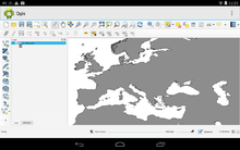
As of 2017, QGIS is available for multiple operating systems including Mac OS X, Linux, Unix, and Microsoft Windows.[9] A mobile version of QGIS was under development for Android as of 2014.[10]
QGIS can also be used as a graphical user interface to GRASS. QGIS has a small install footprint on the host file system compared to commercial GISs and generally requires less RAM and processing power; hence it can be used on older hardware or running simultaneously with other applications where CPU power may be limited.
QGIS is maintained by volunteer developers who regularly release updates and bug fixes. As of 2012, developers have translated QGIS into 48 languages and the application is used internationally in academic and professional environments. Several companies offer support and feature development services.[11]
Function
Layers
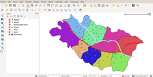
QGIS can display multiple layers containing different sources or depictions of sources.
Preparing maps
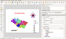
In order to prepare printed map with QGIS, Print Layout is used. It can be used for adding multiple map views, labels, legends, etc.
Licensing
As a free software application under GNU GPLv2, QGIS can be freely modified to perform different or more specialized tasks. Two examples are the QGIS Browser and QGIS Server applications, which use the same code for data access and rendering, but present different front-end interfaces.
Adoption
Many public and private organizations have adopted QGIS, including:
- US National Security Agency [12]
- Austrian state of Vorarlberg
- Swiss cantons of Glarus and Solothurn [13]
- New Zealand's Land Information public service department [14]
Training
Many QGIS training opportunities are available including dedicated YouTube Channels,[15][16] online tutorials,[17] and textbooks [18]
Releases
| Version | Codename | Release date | Significant changes |
|---|---|---|---|
| 0.0.1-alpha | July 2002 | Import and view data from PostGIS[19] | |
| 0.0.3-alpha | 10 August 2002 | Added support for shapefiles and other vector formats.[19] | |
| 0.0.4-alpha | 15 August 2002 | Improvements in layers handling, colorize layers, and view properties in a dialog box.[19] | |
| 0.0.5-alpha | 5 October 2002 | Bug fixes and improved stability, ability to set line widths, and improved zoom in/out functionality.[19] | |
| 0.0.6 | 24 November 2002 | Improvements to PostGIS connections, layer identify function added, and ability to view and sort attribute tables.[19] | |
| 0.0.7 | 30 November 2002 | ||
| 0.0.8 | 11 December 2002 | ||
| 0.0.9 | 25 January 2003 | ||
| 0.0.10 | 13 May 2003 | ||
| 0.0.11 | 10 June 2003 | ||
| 0.0.12 | 10 June 2003 | ||
| 0.0.13 | 8 December 2003 | ||
| 0.1pre1 | 14 February 2004 | Added support for raster data; single, continuous, and graduated shading for vector data; ability to create buffers, implemented as a PostGIS plugin.[20][21] | |
| 0.1 | Moroz | 25 February 2004 | |
| 0.2 | Pumpkin | 26 April 2004 | |
| 0.3 | Madison | 28 May 2004 | |
| 0.4 | Baby | 4 July 2004 | |
| 0.5 | Bandit | 5 October 2004 | |
| 0.6 | Simon | 19 December 2004 | |
| 0.7 | Seamus | ||
| 0.7.3 | 11 October 2005 | ||
| 0.8 | Joesephine | 7 January 2007 | |
| 0.8.1 | Titan | 15 June 2007 | |
| 0.9.0 | 26 October 2007 | ||
| 0.9.1 | Ganymede | 6 January 2008 | |
| 0.10 | Io | 3 May 2008 | |
| 0.11 | Metis | 21 July 2008 | |
| 1.0 | Kore | 5 January 2009 | |
| 1.1 | Pan | 12 May 2009 | |
| 1.2 | Daphnis | 1 September 2009 | |
| 1.3 | Mimas | 20 September 2009 | |
| 1.4 | Enceladus | 10 January 2010 | |
| 1.5 | Tethys | 29 July 2010 | |
| 1.6 | Copiapó | 27 November 2010 | |
| 1.7 | Wrocław | 19 June 2011 | |
| 1.8 | Lisboa | 21 June 2012 | "Mojibake" in Japanese environment. |
| 2.0 | Dufour | 8 September 2013 | New vector API, integration of SEXTANTE geoprocessor, symbology and labeling overhaul. Renamed to QGIS. |
| 2.2 | Valmiera | 22 February 2014 | 2.2 changelog[22] |
| 2.4 | Chugiak | 27 June 2014 | 2.4 changelog |
| 2.6 | Brighton | 1 November 2014 | 2.6 changelog |
| 2.8 LTR | Wien | 20 February 2015 | 2.8 changelog |
| 2.10 | Pisa | 26 June 2015 | 2.10 changelog |
| 2.12 | Lyon | 23 October 2015 | 2.12 changelog |
| 2.14 LTR | Essen | 29 February 2016 | 2.14 changelog; latest point release = 2.14.22 from 20 January 2018 |
| 2.16 | Nødebo | 8 July 2016 | 2.16 changelog |
| 2.18 LTR | Las Palmas | 21 October 2016 | Final release in the 2.x series.[23] Based on Qt4, Python 2.7. Latest point release = 2.18.28 from 18 January 2019. 2.18 changelog |
| 3.0 | Girona | 23 February 2018 | Based on Qt5, PyQt5, and Python 3.[24] Latest point release = 3.0.3 from 18 May 2018. 3.0 changelog |
| 3.2 | Bonn | 22 June 2018 | 3.2 changelog |
| 3.4 LTR | Madeira | 26 October 2018 | 3.4 changelog |
| 3.6 | Noosa | 22 February 2019 | 3.6 changelog |
| 3.8 | Zanzibar | 21 June 2019 | 3.8 changelog |
| 3.10 LTR | A Coruña | 25 October 2019 | 3.10 changelog |
| 3.12 | București | 21 February 2020 | 3.12 changelog |
| 3.14 | Pi | 19 June 2020 | A special name has been given by the community to this version. Bug fix versions are adding more decimals to the Pi number. |
| 3.16 LTR | 23 October 2020 | ||
| 3.18 | 19 February 2021 | ||
Old version Older version, still maintained Latest version Future release | |||
References
- "Releases - qgis/QGIS". Retrieved 24 February 2020 – via GitHub.
- "Changelog for QGIS 2.0 - Quantum GIS is now known only as 'QGIS'". QGIS. Retrieved 1 January 2020.
- "QGIS Official Website". QGIS. Retrieved 16 October 2013.
- Gray, James (2008-03-26). "Getting Started With Quantum GIS". Linux Journal.
- Cavallini, Paolo (August 2007). "Free GIS desktop and analyses: QuantumGIS, the easy way". The Global Geospatial Magazine.
- OSGeo (February 2008). "OSGeo Annual Report 2007".
- Tim Sutton (January 23, 2009). "Announcing the release of QGIS 1.0 'Kore'". Retrieved 2009-01-26.
- "Project details for Quantum GIS - Quantum GIS 0.9.0". Freshmeat. Retrieved 2008-12-31.
- "Download QGIS". QGIS.org. Retrieved March 31, 2017.
- "QGIS for Android". Archived from the original on 21 October 2011. Retrieved 25 September 2014.
- "Commercial support". www.qgis.org. Retrieved 2017-05-01.
- "QGIS related repositories on GitHub - NSA". GitHub. Retrieved 31 March 2020.
- "QuantumGIS (QGIS) – freie GIS-Software". Land Vorarlberg. Retrieved 12 October 2013.
- "QGIS related repositories on GitHub - LINZ". GitHub. Retrieved 31 March 2020.
- https://www.youtube.com/playlist?list=PLEG4qT_nMsCVEb0D0V8KFYJFC2UvXiipD
- https://www.youtube.com/watch?v=lg9ceXoCUFE
- https://www.qgistutorials.com/en/
- https://www.packtpub.com/big-data-and-business-intelligence/mastering-qgis-second-edition
- "QGIS Change Log". Open Source Geospatial Foundation. 2004-03-09. Retrieved 2008-12-13.
- "README for QGIS version 0.1pre1 'Moroz'". Open Source Geospatial Foundation. Retrieved 2008-12-31.
- "Quantum GIS 0.1pre1 (Development)". Freshmeat News. Freshmeat. 2004-02-14. Retrieved 2008-12-31.
- Fischer, Jürgen E. "Announcing the release of QGIS 2.2". OSGeo.org. Retrieved 22 February 2014.
- "Changelog for QGIS 2.18". QQIS.org. October 21, 2016. Retrieved March 31, 2017.
- Sutton, Tim (January 17, 2016). "Help us to plan for QGIS 3.0". QGIS.org. Retrieved March 31, 2017.
External links
| Wikimedia Commons has media related to QGIS. |