Punta Merciantaira
The Punta Merciantaira (in Italian[3] ) or Grand Glaiza (in French[1]) is a 3,293 metres high mountain of the Cottian Alps.[4]
| Punta Merciantaira | |
|---|---|
| Grand Glaiza | |
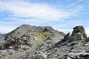 The French side of the mountain | |
| Highest point | |
| Elevation | 3,293 m (10,804 ft) [1] |
| Prominence | 479 m (1,572 ft) [2] |
| Listing | Alpine mountains above 3000 m |
| Coordinates | 44°50′57″N 6°52′57″E |
| Geography | |
 Punta Merciantaira Location in the Alps | |
| Location | Provence-Alpes-Côte d'Azur, France Piemonte, Italy |
| Parent range | Cottian Alps |
| Climbing | |
| Easiest route | Hike |
Geography
The peak is located on the French-Italian border between the Metropolitan City of Turin (Piedmont) and the French department of Hautes-Alpes (Provence-Alpes-Côte-d'Azur). It belongs to the Main chain of the Alps. Administratively the mountain is part of the Italian comune of Cesana Torinese (north face) and the French commune of Cervières.
SOIUSA classification
According to SOIUSA (International Standardized Mountain Subdivision of the Alps) the mountain can be classified in the following way:[5]
- main part = Western Alps
- major sector = South Western Alps
- section = Cottian Alps
- subsection = Central Cottian Alps
- supergroup = Catena Bric Froid-Rochebrune-Beal Traversier
- group = Gruppo Ramière-Merciantaira
- subgroup = Sottogruppo del Merciantaira
- code = I/A-4.II-B.4.b
Access to the summit
The summit of the Grand Glaiza can be easily accessed starting from Les Fonts (commune of Cervières) in less than 4 hours' walk following a waymarked foothpath[6]. The easiest route from the Italian side, starting from Grange di Thuras (Cesana Torinese), is longer and requires a good hiking experience.[7]
References
- "Géoportail" (in French). IGN. Retrieved 2018-11-28.
- "Grand Glaiza - Peakbagger". peakbagger.com. Retrieved 24 May 2020.
- AA.VV. (1899). Rivista mensile (in Italian). 18. Club Alpino Italiano - Consiglio direttivo (Sede centrale). p. 113. Retrieved 2018-11-28.
- Reynolds, Kev (2011). Walking in the Alps: a comprehensive guide to walking and trekking throughout the Alps. Cicerone Press Limited. p. 17. Retrieved 2018-11-28.
- Marazzi, Sergio (2005). Atlante Orografico delle Alpi. SOIUSA (in Italian). Priuli & Verlucca. p. 88. ISBN 978-88-8068-273-8.
- user mario-mont (2009-07-19). "Merciantaira (Punta) o Grand Glaiza da les Fonts" (in Italian). Retrieved 2018-11-26.
- user diecimilapiedi (2012-07-02). "Merciantaira (Punta) o Grand Glaiza da grange Thuras" (in Italian). Retrieved 2018-11-28.
Maps
- Italian official cartography (Istituto Geografico Militare - IGM); on-line version: www.pcn.minambiente.it
- French official cartography (Institut géographique national - IGN); on-line version: www.geoportail.fr
- Istituto Geografico Centrale - Carta dei sentieri e dei rifugi scala 1:50.000 n. 1 Valli di Susa Chisone e Germanasca
External links
![]()
- "360 degrees panoramic photograph from the summit". Pano.ica-net.it.