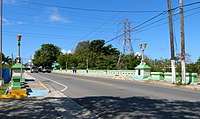
Puente Río Portugués
The Puente Río Portugués is a historic bridge over the former course of the Río Portugués in barrio Playa in the municipality of Ponce, Puerto Rico. The bridge was added to the U.S. National Register of Historic Places in 2015.[2] The bridge is prominent as "the oldest longitudinal steel beams / reinforced concrete bridge built within the historic Carretera Central".[3] It is located on Avenida Hostos, just south of its intersection with Ponce By Pass.
Puente Río Portugués | |
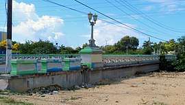 The bridge in 2017, looking south-southeast | |
| Location | Ave. Hostos, km 3.9 Bo. Playa, Ponce, PR |
|---|---|
| Area | 1,140 m2 (12,300 sq ft) |
| MPS | Historic Bridges of Puerto Rico MPS |
| NRHP reference No. | 14001134 |
| Added to NRHP | 6 January 2015 |
Puente Río Portugués | |
|---|---|
| Coordinates | 17°59′36″N 66°36′55″W |
| Crosses | Río Portugués |
| Locale | Bo. Playa, Ponce, Puerto Rico |
| Other name(s) | Bridge 0145 |
| Maintained by | Ponce Dept of Public Works |
| Preceded by | Puente Alfonso XII(1876-1899) Ponce Electric Co.(1899-1933) |
| Characteristics | |
| Design | Art Deco |
| Total length | 249 feet (76 m) |
| Width | 49 feet (15 m) |
| No. of lanes | 2 lanes |
| History | |
| Designer | Rafael Nones |
| Engineering design by | René Esteves |
| Constructed by | Victor A. Auffant |
| Construction cost | $48,484 ($958 thousand in 2019 dollars[1]) |
| Opened | 1933 |
| Replaces | Puente Ponce Electric Co. |
| Statistics | |
| Daily traffic | 8,000 |
| Toll | No |

| |
History
On 25 September 1852, the editor of Ponce newspaper El Ponceño suggested a bridge be built where Río Portugués is currently located. In 1856, the Ponce City Hall took on the matter and named a commission to detail the budget needed to build a bridge over Rio Portugues. On 25 June 1857, the Puerto Rico Bidding Board opened up the bidding process and, having only one bid, it was given to Juan Bertoli Calderoni for his 12,400 pesos quote. The bridge would be known as Principe de Asturias Bridge or Principe Alfonso Bridge. The bridge opened in 1862. However, in 1864, there were floods that raze and destroyed it.[4]
In 1876, the first non wooden bridge built at the site was brought from France, christened with the name Alfonso XII,[5] and installed that year. This metal bridged was used for 23 years until the river knocked it off as a result of the rising waters from Hurricane San Ciriaco in 1899.[6]
The French bridge was recovered 15 years later, in 1914, and installed near Yauco, over Yauco's Rio Duey,[7] where it provided service until 1991,[8] and today (2011) in can be seen at the Parque Urbano de Yauco, on highway PR-127 near the intersection with PR-128.[9]
Thirty-four years after the hurricane, in 1933, the current bridge, Puente Rio Portugues, was inaugurated. A steel plaque identifies the sitting governor and other officials at the time.[9] It was built at a cost of $48,484 ($958 thousand in 2019 dollars[1]).
Architecture
The bridge is architecturally Art Deco style and structurally it is built as a longitudinal beam with the exterior made up of reinforced concrete, steel, and cast iron.[3] Rafael Nones of the Puerto Rico Department of the Interior was in charge of its design.[9]
See also
- Puente de los Leones
- National Register of Historic Places listings in Ponce, Puerto Rico
References
- Federal Reserve Bank of Minneapolis. "Consumer Price Index (estimate) 1800–". Retrieved 1 January 2020.
- National Park Service (16 January 2015), Weekly List of Actions Taken on Properties: 1/05/15 through 1/09/15, archived from the original on 26 April 2016, retrieved 7 April 2016.
- Llanes Santos, Juan (12 November 2014), National Register of Historic Places Registration Form: Puente Río Portugués (PDF), archived (PDF) from the original on 15 April 2019, retrieved 7 April 2016.
- Eli D. Oquendo-Rodriguez. Pablo L. Crespo-Vargas, editor. A Orillas del Mar Caribe: Boceto historico de la Playa de Ponce - Desde sus primeros habitantes hasta principios del siglo XX. First edition. June, 2017. Editorial Akelarre. Centro de Estudios e Investigaciones del Sur Oeste de Puerto Rico (CEISCO). Lajas, Puerto Rico. Pages 56-60. ISBN 1547284935 ISBN 978-1547284931
- La Carretera Central - Su Historia: Seccion Juana Diaz-Ponce. Juan E. Castillo. Revista de Obras Publicas de Puerto Rico (Puerto Rico Public Works Journal). Year VII. Number 6. (June 1930) p.145-146. Accessed 8 February 2018.
- La Carretera Central: Un Viaje Escénico a la Historia de Puerto Rico. Luis Pumarada O'Neill and Maria de los Angeles Castro Arroyo. Centro de Investigación y Desarrollo de la Universidad de Puerto Rico en Mayaguez. Prepared for: Oficina Estatal de Preservación Histórica de Puerto Rico. 1996. p.14. Accessed 8 February 2018.
- La Carretera Central - Su Historia: Sección Juana Diaz-Ponce. Juan E. Castillo. Revista de Obras Publicas de Puerto Rico (Puerto Rico Public Works Journal). Year VII. Number 6. (June 1930) p.146. Accessed 8 February 2018.
- La carretera Central: Un Viaje Escenico a la Historia de Puerto Rico. Luis Pumarada O'Neill and Maria de los Angeles Castro Arroyo. Centro de Investigacion y Desarrollo de la Universidad de Puerto Rico en Mayaguez. Prepared for: Oficina Estatal de Preservacion Historica de Puerto Rico. 1996. p.14. Accessed 8 February 2018.
- De San Juan a Ponce por la Carretera Central. Jose A. Mari Mut. Copyright 2011-2013. p. 132. Accessed 8 February 2018.
External links

- Summary sheet from the Puerto Rico State Historic Preservation Office (in Spanish)
- Historic Bridges of Puerto Rico MPS, National Register of Historic Places cover documentation
Further reading
- Abbad y Lasierra, Inigo. Historia geográfica, civil y natural de la Isla de San Juan Bautista de Puerto Rico. Anotada en la parte historica y continuada en la estadistica y economica por Jose Julian Acosta y Calbo. Ediciones Doce Calles. 2002.
- Archivo General de Puerto Rico. Fondo: Obras Publicas. Serie: Carreteras y Puentes. Caja 2154, Legajo 53N; Caja 2155, Legajo 53"O"; Caja 2156, Legajo 53P; Caja 2157. Legajo 53Q (Construccion Puente Rio Portugues).
- Archivo General de Puerto Rico. Gobierno de Puerto Rico. Estadistica general del comercio exterior o balancas mercantiles, 1895.
- Archivo General de Puerto Rico. Postales de la Coleccion Jungham.
- Franchises Granted by the extinct Executive Council and the Public Service Commission of Porto Rico. Franchise Ordinance No. 3. Volume 1I. 26 November 1901 to 21 May 1915. San Juan, Puerto Rico. Bureau of Supplies, Printing, and Transportation. 1924.
- Marin, Ramon. La Villa de Ponce considerada en tres distantas epocas: Estudio histórico, descriptivo y estadístico hasta finales del año 1876. Editoriales publicados en el periódico "La Crónica". Establecimiento Tipográfico "El Vapor". Ponce, Puerto Rico. 1877. See, Ramon Marín, Obras Completas. Ponce, Puerto Rico. 1989.
- Pumarada, O'Neill, Luis and Maria de los Angeles Castro. La Carretera Central. Un viaje escenico a la historia de Puerto Rico. Centro de Investigacion y Desarrollo. Universidad de Puero Rico, Reciento de Mayaguez. Oficina Estatal de Preservacion Historica. September 1977.
- Revista de Obras Publicas de Puerto Rico. Year XI. Number 6. June 1934.
- Tomas de Cordova, Pedro. Memorias geográficas, historicas y estadisticas de la isla de Puerto Rico. Tomo II. Year: 1831. Instituto de Cultura Puertorriqueña. San Juan, Puerto Rico. 1968.
- Ubeda y Delgado, Manuel. Isla de Purto Rico: Estudio histórico, geografico y estadistico de la misma. Puerto Rico. Establecimiento Tip. Del Boletin. 1878.
| Topics | |
|---|---|
| Lists by state |
|
| Lists by insular areas | |
| Lists by associated state | |
| Other areas | |
| Related | |
| |