Province of Ávila
Ávila (pronounced [ˈaβila] (![]()
Ávila Provincia de Ávila | |
|---|---|
 Flag  Coat of arms | |
 Map of Spain with Ávila highlighted | |
| Coordinates: 40°35′N 5°00′W | |
| Country | Spain |
| Autonomous community | Castille and León |
| Capital | Ávila |
| Government | |
| • President | Carlos García González (PP) |
| Area | |
| • Total | 8,048 km2 (3,107 sq mi) |
| Area rank | Ranked 30 |
| 1,60% of Spain | |
| Population | |
| • Total | 158,265 |
| • Rank | Ranked 47 |
| • Density | 20/km2 (51/sq mi) |
| 0,37% of Spain | |
| Demonym(s) | Spanish: abulense |
| Website | www |
Geography
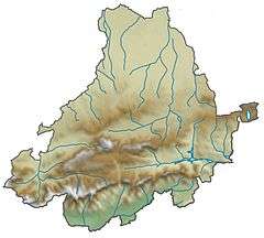
Ávila is naturally divided into two sections, differing completely in soil and climate. The northern portion is generally level; the soil is of indifferent quality, strong and marly in a few places, but rocky in all the valleys of the Sierra de Ávila; and the climate alternates from severe cold in winter to extreme heat in summer. The population of this part is mainly agricultural. The southern division is one mass of rugged granitic sierras, interspersed, however, with sheltered and well-watered valleys, abounding with rich vegetation.
The winter here, especially in the elevated region of the Paramera and the waste lands of Ávila, is long and severe, but the climate is not unhealthy.
The principal mountain chains are the Guadarrama, separating this province from Madrid; the Paramera and Sierra de Ávila, west of the Guadarrama; and the vast wall of the Sierra de Gredos along the southern frontier, where its outstanding peaks rise to 6000 or even 8000 ft. Pico Almanzor is the highest point. The ridges which ramify from the Paramera are covered with valuable forests of beeches, oaks and firs, presenting a striking contrast to the bare peaks of the Sierra de Gredos.
The principal rivers are the Alberche and Tiétar, belonging to the basin of the Tagus, and the Tormes, Trabancos and Adaja, belonging to that of the Douro.
History
The first recorded inhabitants of Ávila were the Celts, who left behind a number of large stone statues of bulls called Verracos, with the largest number of surviving examples in Ávila. The area of the province was conquered by the Romans around 192 B.C. After the Roman Empire fell, the area became part of the Visigothic Kingdom, and it is from this period we have many of the earliest records of the towns of Ávila.
The province declined in wealth and population during the 18th and 19th centuries, a result due less to the want of activity on the part of the inhabitants than to the oppressive manorial and feudal rights and the strict laws of entail and mortmain, which acted as barriers to progress.
See also
References
- Chisholm, Hugh, ed. (1911). . Encyclopædia Britannica (11th ed.). Cambridge University Press.
External links
![]()