Prien (river)
Its source is at 1,150 metres (3,770 ft) above sea level at the Spitzstein. After 33 kilometres (21 mi) it discharges into the Chiemsee at the bay Schafwaschener Bucht. It is one of the longest mountain streams in the Bavarian Alps. The name probably derives from the Celtic name of the river, Brigenna, the one coming from the mountains (female) in Celtic languages. The town Prien am Chiemsee was named after the river. Before Prien, on a weir the Mühlbach is fed, which flows independently into the Chiemsee further southward.
| Prien | |
|---|---|
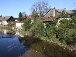 The Prien in the eponymous town | |
| Location | |
| Country | Germany |
| States | Bavaria |
| Physical characteristics | |
| Source | |
| ⁃ location | Spitzstein |
| ⁃ elevation | 1,150 metres (3,770 ft) |
| Mouth | |
⁃ location | at Prien am Chiemsee into the Chiemsee |
⁃ coordinates | 47.8756°N 12.3586°E |
⁃ elevation | 518 metres (1,699 ft) |
| Length | 33.4 km (20.8 mi) [1] |
| Basin size | 246 km2 (95 sq mi) [1] |
| Basin features | |
| Progression | Alz→ Inn→ Danube→ Black Sea |
Prien is a river of Bavaria, Germany.
The Prien is, after the Tiroler Achen, the second largest tributary to the Chiemsee.
See also
References
- Complete table of the Bavarian Waterbody Register by the Bavarian State Office for the Environment (xls, 10.3 MB)
This article is issued from Wikipedia. The text is licensed under Creative Commons - Attribution - Sharealike. Additional terms may apply for the media files.