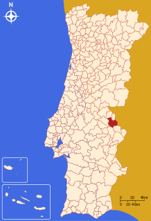
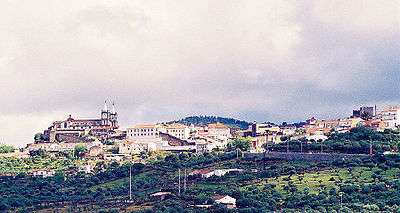
Portalegre, Portugal
Portalegre (Portuguese pronunciation: [puɾtɐˈlɛɣɾ(ɨ)] (![]()
Portalegre | |
|---|---|
_(cropped).jpg) _(cropped).jpg) 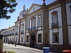 _(cropped).jpg) .jpg) _(cropped).jpg) | |
 Flag  Coat of arms | |
 | |
| Coordinates: 39°19′N 7°25′W | |
| Country | |
| Region | Alentejo |
| Intermunic. comm. | Alto Alentejo |
| District | Portalegre |
| Parishes | 7 |
| Government | |
| • President | Adelaide Teixeira (Independent) |
| Area | |
| • Total | 447.14 km2 (172.64 sq mi) |
| Population (2011) | |
| • Total | 24,930 |
| • Density | 56/km2 (140/sq mi) |
| Time zone | UTC±00:00 (WET) |
| • Summer (DST) | UTC+01:00 (WEST) |
| Local holiday | 23 May |
| Website | http://www.cm-portalegre.pt |
Its name comes from the Latin Portus Alacer (meaning "cheerful port"). The municipal holiday is 23 May. According to the 2001 census the city of Portalegre had 15,768 inhabitants in its two parishes (Sé and São Lourenço). These two parishes plus the eight rural parishes had a total of 25,608 inhabitants. The current Mayor is Adelaide Teixeira, elected as an independent.
History
Portalegre was founded in the reign of Afonso III, in 1259. It was to be given to his son Afonso of Portugal, Lord of Portalegre.
During the reign of Denis I, a foral issued on 18 November 1299 it was determined that Portalegre would be donated to the king and later to his first born and heir.
Portalegre was elevated to the status of city on 23 May 1550, by John III. At this time, the city was regarded as an important administrative and economic centre. In the 15th century, it was already recognized for its cloth manufacturing.
Owing to its proximity to the border with Spain, over the years Portalegre endured many invasions by foreign troops. In 1704, during the War of the Spanish Succession, it was attacked and conquered by the army of Felipe V; again in 1801 during the War of the Oranges, it surrendered to the Spanish Army, in an attempt to counter the French dominion. In 1847 it was occupied by forces of the Spanish General Concha.
The importance of Portalegre would come to be recognized in 1859, when it became capital of the Portalegre District.
Geography
Elevation 483 meters.
Other Features
The house-museum of José Régio, a famous Portuguese poet, was installed in his home, in which he lived for 34 years. When Régio was accepted at the high school of Mouzinho da Silveira, in Portalegre, this place was a hostel. It was previously an annex of the convent of S. Brás, of which there are still some vestiges, namely the chapel. It also served as a headquarters when the peninsular wars were fought, but it was later named Pensão 21.
José Régio rented a humble room and, as he needed more space (he collected several works of art, amongst which more than 400 representations of Christ), he would rent more space. So, as time went by, he finally became the only inhabitant of the hostel. In 1965, he sold his collection to the municipality of Portalegre with the condition of it buying his house, restore it and transform it into a museum. He lived there until he died, in 1969. The museum opened to public in 1971.
Climate
| Climate data for Portalegre | |||||||||||||
|---|---|---|---|---|---|---|---|---|---|---|---|---|---|
| Month | Jan | Feb | Mar | Apr | May | Jun | Jul | Aug | Sep | Oct | Nov | Dec | Year |
| Record high °C (°F) | 21.9 (71.4) |
22.5 (72.5) |
27.4 (81.3) |
31.0 (87.8) |
34.5 (94.1) |
39.5 (103.1) |
40.4 (104.7) |
41.3 (106.3) |
39.5 (103.1) |
32.4 (90.3) |
25.7 (78.3) |
21.1 (70.0) |
41.3 (106.3) |
| Average high °C (°F) | 11.6 (52.9) |
12.9 (55.2) |
16.3 (61.3) |
17.3 (63.1) |
21.0 (69.8) |
26.8 (80.2) |
30.5 (86.9) |
30.5 (86.9) |
26.6 (79.9) |
20.2 (68.4) |
14.9 (58.8) |
12.2 (54.0) |
20.1 (68.2) |
| Daily mean °C (°F) | 8.7 (47.7) |
9.6 (49.3) |
12.2 (54.0) |
13.0 (55.4) |
16.2 (61.2) |
21.1 (70.0) |
24.0 (75.2) |
24.1 (75.4) |
21.4 (70.5) |
16.5 (61.7) |
12.0 (53.6) |
9.4 (48.9) |
15.7 (60.3) |
| Average low °C (°F) | 4.8 (40.6) |
6.2 (43.2) |
8.2 (46.8) |
8.6 (47.5) |
11.3 (52.3) |
15.3 (59.5) |
17.4 (63.3) |
17.7 (63.9) |
16.2 (61.2) |
12.8 (55.0) |
9.1 (48.4) |
6.7 (44.1) |
11.2 (52.2) |
| Record low °C (°F) | −4.5 (23.9) |
−3.7 (25.3) |
−4.3 (24.3) |
−0.2 (31.6) |
2.3 (36.1) |
5.0 (41.0) |
8.2 (46.8) |
9.4 (48.9) |
8.3 (46.9) |
2.8 (37.0) |
0.3 (32.5) |
−1.2 (29.8) |
−4.5 (23.9) |
| Source: [3] | |||||||||||||
Gallery
.jpg) Portalegre, Portugal
Portalegre, Portugal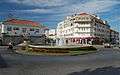 Portalegre, Portugal
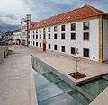 Portalegre, Portugal
 Portalegre, Portugal
 Portalegre, Portugal
- Portalegre, Portugal
.jpg) Portalegre, Portugal
Portalegre, Portugal
Parishes
The municipality is composed of 7 parishes:[4]
- Alagoa
- Alegrete
- Ribeira de Nisa e Carreiras
- Fortios
- Reguengo e São Julião
- Sé e São Lourenço
- Urra
See also
- Portalegre DOC
References
- Instituto Nacional de Estatística
- "Áreas das freguesias, concelhos, distritos e país". Archived from the original on 2018-11-05. Retrieved 2018-11-05.
- "Climate Normals - Portalegre 1981-2010". Portuguese Institute of Meteorology. Retrieved 30 June 2019.
- Diário da República. "Law nr. 11-A/2013, pages 552 98-99" (pdf) (in Portuguese). Retrieved 9 July 2014.
External links
| Authority control |
|
|---|