Port of Stockton
The Port of Stockton is a major deepwater port on the Stockton Ship Channel of the Pacific Ocean and an inland port located more than seventy nautical miles from the ocean, in Stockton, California on the Stockton Channel and San Joaquin River-Stockton Deepwater Shipping Channel (before it joins the Sacramento River to empty into Suisun Bay). The port sits on about 4,200 acres (17 km2), and occupies an island in the Sacramento–San Joaquin River Delta, and a portion of a neighborhood known as Boggs Tract. It is governed by a commission appointed by the City of Stockton and San Joaquin County. In 2012 it employed 4,500 people and made about $4.9 million in local tax funds.[2]
| Port of Stockton | |
|---|---|
 Port of Stockton | |
| Location | |
| Country | United States |
| Location | Stockton, California |
| Coordinates | 37.95164°N 121.31764°W |
| Details | |
| Opened | 1932 |
| Land area | 4,200 acres (17 km2) |
| Available berths | 14 |
| Statistics | |
| Vessel arrivals | 230 (CY 2014) |
| Annual cargo tonnage | 4.1 million metric revenue tons (CY 2014)[1] |
| Value of cargo | US$1.5 billion (CY 2014) |
| Website www.portofstockton.com | |

Geography
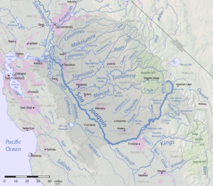
The only natural outlet for the waters of the Central Valley to pass into the sea is through the narrow Carquinez Strait, at the inland eastern extreme of San Pablo Bay. Further inland are the Suisun and Grizzly Bays, arms of the Pacific Ocean deep in the Californian interior. Further inland again from these last bays is the broad Sacramento–San Joaquin River Delta, formed where the San Joaquin and Sacramento Rivers meet and cross together. This verdant triangle of land with deep black soils is at the heart of the Central Valley and stretches some fifty miles from Suisun Bay on the west to the cities of Stockton and Sacramento on the east.
Pollution
The California Office of Environmental Health Hazard Assessment has issued advice based on PCBs that no one should eat any fish or shellfish from the Port of Stockton.[3]
History
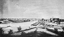
In 1846, the first cargo boat ascended the San Joaquin River. In 1848, John Doak established the first ferry service on the river, and the first freight vessel, the sloop Maria, visited Stockton. In 1849, Doak brought lumber from San Francisco to Stockton and began a lumber business. By the 1850s, the port had become a center of commodity shipping and the supply center for the California goldfields. By the 1860s, the region saw a decline in gold production and an increase in agriculture.
The first dredging contracts for the Stockton Deepwater Channel were awarded in 1930. The Port District officially opened on February 2, 1933 when the ship the Daisy Grey arrived bringing lumber from Oregon.
Port management recognized the increasing importance of containerized cargo and upgraded dock side facilities. The ship channel was improved in order to accommodate large Panamax class ships.
The Navy Rough and Ready Island Naval Supply Depot built during World War II was phased out of use as a result of special legislation sponsored by United States Senate Dianne Feinstein in 1995. It was transferred to the port between 2000 and 2003. This area of the port is now known as the "West Complex".[4]
Port services

- The deepwater channel is about 35 feet (10 meters) deep, handling ships up 900 feet (275 meters) and 60,000 tons. Dockside transit sheds of up to 1.1 million square feet (102,000 sq. meters). Warehouse storage of up to 7.7 million square feet (715,000 sq. meters).
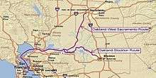
- The port runs a marine highway barge service for moving containers to Oakland for shipping.
- The Port is a Foreign Trade Zone.
- The port has two 140-ton mobile harbor cranes.[5]
- The port handles both large volume of bulk cargo and containerization shipments on container ship.
- The port is served by three railroads: Central California Traction Company handles local rail shipments while Union Pacific (UP) and Burlington Northern Santa Fe (BNSF) provide rail connections to the rest of North America. Port of Stockton has 60 miles of rail lines shipping over 2,090,400 short tons a year.[6]
- The port is serviced by Interstate 5, California State Route 4, and California State Route 99. Over 200 truck companies serve the Port. Interstate 80 is about 50 miles north of the port.
- The port handles containers going in and out of Sacramento, as the Port of Sacramento is a container free port.
- The port is part of the California’s Green Trade Corridor Marine Highway project, as ships move cargo much greener than trucks and trains. Green Trade Corridor Marine Highway (ports of Oakland-Stockton-West Sacramento) can improve goods movement through Northern California.[7]
References
- "Port of Stockton sets record for shipping in 2014".
- "Caltrans Port of Stockton Fact Sheet" (PDF). Retrieved April 7, 2014.
- Admin, OEHHA (2015-02-25). "Port of Stockton". OEHHA. Retrieved 2018-03-21.
- Fujii, Reed. "Ready, no longer Rough".
- Magazine, Pacific Maritime. "M-580: California's Marine Highway".
- http://www.portofstockton.com/. Missing or empty
|title=(help) - "Green Trade Corridor Marine Highway - Port of Oakland".
External links
| Panamax ports | |
|---|---|
| Non-panamax ports | |
| Canals | |
| Alternate West Coast Seaports |
|
| West Coast LNG Terminals | |