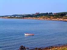
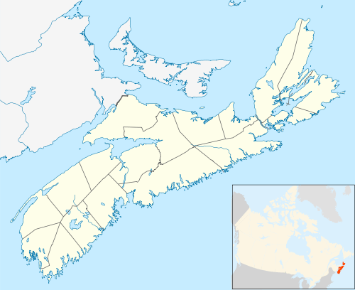
Port Hood, Nova Scotia
Port Hood (Scottish Gaelic: Seastago) is a Canadian community on the west coast of Cape Breton Island and the shire town of Inverness County, Nova Scotia, Canada. Local residents are predominantly English-speaking Roman Catholics, the population core having Scottish Highlands ancestry; MacDonalds,Macdonnell and Gillies mostly. The community is named after Samuel Hood, 1st Viscount Hood.[1]
Geography
The village is located on Trunk 19 (the "Ceilidh Trail"), approximately 30-minutes drive north from the Canso Causeway which links mainland Nova Scotia to Cape Breton Island.
Climate
| Climate data for Port Hood | |||||||||||||
|---|---|---|---|---|---|---|---|---|---|---|---|---|---|
| Month | Jan | Feb | Mar | Apr | May | Jun | Jul | Aug | Sep | Oct | Nov | Dec | Year |
| Record high °C (°F) | 14.5 (58.1) |
12.2 (54.0) |
18 (64) |
23 (73) |
29 (84) |
31.7 (89.1) |
35 (95) |
32.5 (90.5) |
29 (84) |
23.9 (75.0) |
20 (68) |
16.1 (61.0) |
35 (95) |
| Average high °C (°F) | −1.6 (29.1) |
−2.2 (28.0) |
1.6 (34.9) |
6.6 (43.9) |
12.4 (54.3) |
18.3 (64.9) |
22.9 (73.2) |
22.3 (72.1) |
17.7 (63.9) |
12.4 (54.3) |
6.6 (43.9) |
1.8 (35.2) |
9.9 (49.8) |
| Average low °C (°F) | −9.7 (14.5) |
−10.3 (13.5) |
−6.5 (20.3) |
−1 (30) |
3.6 (38.5) |
9 (48) |
14.2 (57.6) |
14 (57) |
9.9 (49.8) |
5.4 (41.7) |
0.7 (33.3) |
−5.3 (22.5) |
2 (36) |
| Record low °C (°F) | −25.5 (−13.9) |
−28 (−18) |
−26 (−15) |
−13.3 (8.1) |
−7 (19) |
−3 (27) |
2.5 (36.5) |
3.3 (37.9) |
−1.1 (30.0) |
−4 (25) |
−9 (16) |
−21 (−6) |
−28 (−18) |
| Average precipitation mm (inches) | 109.7 (4.32) |
90.8 (3.57) |
95.1 (3.74) |
101.4 (3.99) |
87.8 (3.46) |
95.2 (3.75) |
94.2 (3.71) |
117.6 (4.63) |
116 (4.6) |
134 (5.3) |
120.7 (4.75) |
135.3 (5.33) |
1,297.8 (51.09) |
| Source: Environment Canada[2] | |||||||||||||
History
Coal mines operated in the town, most notably in the two decades after the Inverness & Richmond Railway reached the community in 1900.[3] The economy of Port Hood revolves around farming (especially dairy cattle) and fishing; lobster and Atlantic bluefin tuna particularly. However, most residents of Port Hood commute to work in communities like Port Hawkesbury. Port Hood experienced an economic boom from 1880 to 1910, with the coal mining, fishing and marine trade. A fire in July 1942 destroyed much of the town's business district. In 1946, the town was incorporated due to a declining population.

Construction of Highway 105 (the Trans-Canada Highway) between North Sydney and the Canso Causeway in the 1960s resulted in the re-routing of most Cabot Trail tourism traffic. The Cabot Trail is now advertised with its start and end-point in Baddeck, bypassing the traditional western approach to the Cabot Trail through Judique, Port Hood, Inverness and Margaree Harbour, and thus decreasing tourism traffic on the Ceilidh Trail.
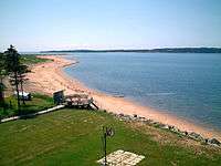
Port Hood is known to have some of the warmest waters in Eastern Canada. Its miles of golden sandy beaches draw in tourists from across the globe during the summer season. It is also home to the Chestico Museum.
Notable people
Port Hood is the birthplace of all-star (ice) hockey, Olympic gold medal winner Al MacInnis, as well as that of Grey Cup Canadian Football League Champion Bruce Beaton.
References
- https://archive.org/stream/placenamesofprov00browuoft#page/116/mode/2up
- Environment Canada Canadian Climate Normals 1971–2000, accessed 16 July 2009
- Maritime Mining Record 11 September 1900.
External links
| Wikimedia Commons has media related to Port Hood, Nova Scotia. |