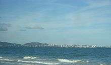
Porlamar
Porlamar is the largest city on Isla Margarita, Nueva Esparta State in Venezuela.
Porlamar | |
|---|---|
 | |
 Flag | |
| Nicknames: Villa del Espíritu Santo (English: House of the Holy Spirit)
Pueblo de La Mar (English: Village by the Sea) | |
.svg.png) Porlamar | |
| Coordinates: 10°57′N 63°51′W | |
| Country | |
| State | Nueva Esparta |
| Counties | Mariño |
| Demonym | Porlamarense |
| Government | |
| • Mayor | Alfredo Díaz |
| Elevation | 10 m (32 ft) |
| Population (2011) | |
| • Total | 144,830 |
| Postal coded | 6301 |
| Area code | 295 |
| Climate | BSh |
| Website | Municipality of Mariño |
History
The city was founded as Puerto de la Mar (now Porlamar) on the southeast coast in 1536, less than 40 years after Christopher Columbus first sailed through.
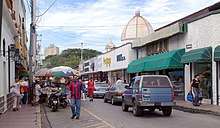
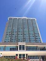
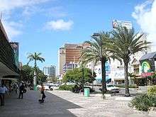
In 1680 the Council of the Indies ordered Margarita born Juan Fermín de Huidobro to build a fortress with four bastions and a watchtower known as San Carlos Borromeo.[1] Porlamar was a quiet fishing village until the arrival of air travel. Since then, it has become the central hub of the island with shops, restaurants and nightlife supported mostly by European and Venezuelan tourism.
Demographics
Porlamar holds about one-third of Margarita Island's population.
Economy
Porlamar is Margarita Island's center of commerce. Since it was granted free-port status in 1973, its boutique-lined avenues have been crowded with tourists. In the late 1990s, the economic downfall hit Porlamar.
Transportation
Del Caribe International General Santiago Marino Airport (PMV) in Porlamar has charter services to Europe and Colombia as well as scheduled passenger flights to destinations in Venezuela and is located 20 kilometres (12 mi) southwest of the city center.
Climate
| Climate data for Porlamar | |||||||||||||
|---|---|---|---|---|---|---|---|---|---|---|---|---|---|
| Month | Jan | Feb | Mar | Apr | May | Jun | Jul | Aug | Sep | Oct | Nov | Dec | Year |
| Record high °C (°F) | 32.9 (91.2) |
34.2 (93.6) |
36.0 (96.8) |
34.9 (94.8) |
34.9 (94.8) |
34.7 (94.5) |
34.5 (94.1) |
36.0 (96.8) |
35.8 (96.4) |
35.5 (95.9) |
35.8 (96.4) |
35.3 (95.5) |
36.0 (96.8) |
| Average high °C (°F) | 30.0 (86.0) |
30.4 (86.7) |
31.1 (88.0) |
31.9 (89.4) |
32.2 (90.0) |
31.5 (88.7) |
31.7 (89.1) |
32.3 (90.1) |
32.8 (91.0) |
32.6 (90.7) |
31.7 (89.1) |
30.4 (86.7) |
31.6 (88.9) |
| Daily mean °C (°F) | 25.9 (78.6) |
26.0 (78.8) |
26.5 (79.7) |
27.3 (81.1) |
27.7 (81.9) |
27.4 (81.3) |
27.5 (81.5) |
28.0 (82.4) |
28.3 (82.9) |
28.2 (82.8) |
27.7 (81.9) |
26.5 (79.7) |
27.3 (81.1) |
| Average low °C (°F) | 23.2 (73.8) |
23.3 (73.9) |
23.7 (74.7) |
24.5 (76.1) |
25.0 (77.0) |
24.9 (76.8) |
24.8 (76.6) |
25.1 (77.2) |
25.5 (77.9) |
25.5 (77.9) |
25.0 (77.0) |
23.9 (75.0) |
24.5 (76.1) |
| Record low °C (°F) | 19.3 (66.7) |
19.3 (66.7) |
19.3 (66.7) |
20.3 (68.5) |
21.4 (70.5) |
21.8 (71.2) |
21.9 (71.4) |
21.2 (70.2) |
21.5 (70.7) |
22.0 (71.6) |
21.7 (71.1) |
20.4 (68.7) |
19.3 (66.7) |
| Average precipitation mm (inches) | 37 (1.5) |
29 (1.1) |
8 (0.3) |
13 (0.5) |
12 (0.5) |
35 (1.4) |
46 (1.8) |
62 (2.4) |
34 (1.3) |
34 (1.3) |
64 (2.5) |
55 (2.2) |
429 (16.9) |
| Average precipitation days (≥ 1.0 mm) | 6.5 | 5.1 | 2.0 | 1.5 | 2.3 | 5.3 | 7.8 | 7.1 | 3.9 | 4.1 | 6.9 | 7.3 | 59.8 |
| Average relative humidity (%) | 87 | 87 | 85 | 84 | 86 | 87 | 87 | 85 | 84 | 85 | 86 | 87 | 86 |
| Mean monthly sunshine hours | 285.2 | 259.9 | 282.1 | 255.0 | 260.4 | 237.0 | 260.4 | 279.0 | 270.0 | 272.8 | 270.0 | 269.7 | 3,201.5 |
| Mean daily sunshine hours | 9.2 | 9.2 | 9.1 | 8.5 | 8.4 | 7.9 | 8.4 | 9.0 | 9.0 | 8.8 | 9.0 | 8.7 | 8.8 |
| Source: Deutscher Wetterdienst[2] | |||||||||||||
Twin cities


References
- Fermín de Huidobro, Juan: mcn.
- "Klimatafel von Porlamar / Insel Margarita / Venezuela" (PDF). Baseline climate means (1961–1990) from stations all over the world (in German). Deutscher Wetterdienst. Retrieved 3 February 2019.