Pongrac
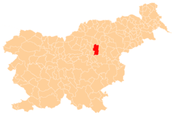
Pongrac (pronounced [pɔŋˈɡɾaːts]) is a settlement in the Municipality of Žalec in east-central Slovenia. It lies in the hills south of Žalec. The area is part of the traditional region of Styria. The municipality is now included in the Savinja Statistical Region.[2]
Pongrac Sveti Pongrac (until 1955) | |
|---|---|
 Pongrac Location in Slovenia | |
| Coordinates: 46°12′58.69″N 15°8′11.81″E | |
| Country | |
| Traditional region | Styria |
| Statistical region | Savinja |
| Municipality | Žalec |
| Area | |
| • Total | 14.01 km2 (5.41 sq mi) |
| Elevation | 317.2 m (1,040.7 ft) |
| Population (2002) | |
| • Total | 798 |
| [1] | |
Name
The name of the settlement was changed from Sveti Pongrac (literally, 'Saint Pancras') to Pongrac (literally, 'Pancras') in 1955. The name was changed on the basis of the 1948 Law on Names of Settlements and Designations of Squares, Streets, and Buildings as part of efforts by Slovenia's postwar communist government to remove religious elements from toponyms.[3][4][5]
Cultural heritage
An Early Iron Age burial ground has been identified in the northwestern part of the settlement, part of a burial ground extending to Sveti Lovrenc in the adjacent Municipality of Prebold and numbering over 180 burial mounds.[6]
Mass graves
Pongrac is the site of two known mass graves from the period immediately after the Second World War. The Britne Sele Mass Grave (Slovene: Grobišče Britne sele), also known as the Haložan Mass Grave (Grobišče pod Haložanom), is located along a wooded slope, at several leveled areas at the edge of the woods. It is south of the house at Pongrac no. 63 and contains the remains of an unknown number of people murdered after the Second World War.[7] The Snowdrop Valley Mass Grave (Grobišče Dolina zvončkov), also known as the Griže Mass Grave (Grobišče Griže), is located in a swampy area along Zibika Creek. It contains the remains of 80 to 100 young Home Guard soldiers transported from the Teharje camp and murdered here on or about 10 June 1945.[8]
References
- Statistical Office of the Republic of Slovenia
- Žalec municipal site
- Spremembe naselij 1948–95. 1996. Database. Ljubljana: Geografski inštitut ZRC SAZU, DZS.
- Premk, F. 2004. Slovenska versko-krščanska terminologija v zemljepisnih imenih in spremembe za čas 1921–1967/68. Besedoslovne lastnosti slovenskega jezika: slovenska zemljepisna imena. Ljubljana: Slavistično društvo Slovenije, pp. 113–132.
- Urbanc, Mimi, & Matej Gabrovec. 2005. Krajevna imena: poligon za dokazovanje moči in odraz lokalne identitete. Geografski vestnik 77(2): 25–43.
- Slovenian Ministry of Culture register of national heritage reference number ešd 10395
- Ferenc, Mitja (December 2009). "Grobišče Britne sele". Geopedia (in Slovenian). Ljubljana: Služba za vojna grobišča, Ministrstvo za delo, družino in socialne zadeve. Retrieved April 28, 2020.
- Ferenc, Mitja (December 2009). "Grobišče Dolina zvončkov". Geopedia (in Slovenian). Ljubljana: Služba za vojna grobišča, Ministrstvo za delo, družino in socialne zadeve. Retrieved April 28, 2020.
External links
| Settlements | Administrative centre: Žalec
|  | ||||
|---|---|---|---|---|---|---|
| Landmarks | ||||||