Point Danger Light
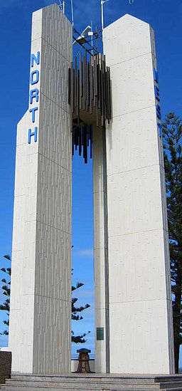
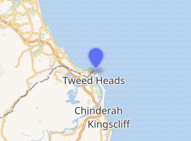
Point Danger Light, also known as the Captain Cook Memorial Light, is an active lighthouse located on Point Danger, a headland between Coolangatta, Queensland and Tweed Heads, New South Wales, marking the border between New South Wales and Queensland, Australia. It lays claim to be the first lighthouse in the world to experiment with laser as a light source.[4]
 Point Danger Light | |
 Queensland | |
| |
| Location | Point Danger Queensland Australia |
|---|---|
| Coordinates | 28°09′54.09″S 153°33′02.63″E |
| Year first constructed | 1971[1] |
| Automated | 1971 |
| Construction | concrete tower |
| Tower shape | four rectangular pillars with a bronze sculpture suspended between them |
| Markings / pattern | white columns, floodlit |
| Tower height | 67 feet (20 m)[2] |
| Focal height | 146 feet (45 m) |
| Light source | mains power |
| Range | 11 nautical miles (20 km; 13 mi)[3] |
| Characteristic | Fl (2) W 10s. |
| Admiralty number | K2845 |
| NGA number | 111-5868 |
| ARLHS number | AUS-132 |
| Managing agent | Australian Maritime Safety Authority |
History
Point Danger Light was the third of a group of seven concrete towers erected between 1964 and 1979 in Queensland, in order of erection Cape Capricorn Light, New Caloundra Light, itself, New Burnett Heads Light, Fitzroy Island Light, Point Cartwright Light and Archer Point Light.[5] Constructed in 1971,[1] it commemorates the bicentennial of Captain Cook's first voyage, and specifically the voyage along the east coast of Australia in 1770.[6] It was first exhibited on 18 April 1971.[7]
The original light source was an experimental laser-based light,[7] and the lighthouse may very well be the first in the world to experiment with this light source. However, the experiment failed,[4] and the light source was replaced in 1975 by a regular electric lamp.[7]
Current display
The light characteristic shown is two white flashes every ten seconds (Fl.(2)W. 10s), visible at 170°-330°[8] for 11 nautical miles (20 km; 13 mi).[3] The light source is an electric lamp, fed by a battery float charged from the mains electricity.[4][7]
Structures
The lighthouse is constructed of four concrete columns, marked with the four cardinal directions, and a bronze sculpture hung between the columns.[9]
Also, near-by is a one-story building housing the Marine Rescue NSW Point Danger station.[9]
Site operation and visiting
The light is operated by Roads and Maritime Services (formerly NSW Maritime).[10] The site is accessible, but the tower is closed to the public.[9]
Notes
- Rowlett, NSW Maritime. Searle states 1970.
- Searle and List of Lights. Rowlett states 66 feet (20 m).
- List of Lights. NSW Maritime states 10 nmi. Lighthouses of Australia Inc and Maizels 1998 list 18 nmi based on an AMSA plaque shown in Maizels 1998b.
- Lighthouses of Australia Inc.
- QHR31351.
- NSW Maritime.
- Maizels 1998b.
- List of Lights.
- Rowlett.
- NSW Maritime. Rowlett and Lighthouses of Australia Inc both state AMSA. However, note that the date of latter is 2003-08-06 and NSW Maritime states some of the lighthouses were transferred in 2004.
References
- List of Lights, Pub. 111: The West Coasts of North and South America (Excluding Continental U.S.A. and Hawaii), Australia, Tasmania, New Zealand, and the Islands of the North and South Pacific Oceans (PDF). List of Lights. United States National Geospatial-Intelligence Agency. 2009. p. 128.
- Rowlett, Russ. "Lighthouses of Australia: Southern Queensland". The Lighthouse Directory. University of North Carolina at Chapel Hill. Retrieved 14 November 2010.
- "The Point Danger Lighthouse". Lighthouses of Queensland. Lighthouses of Australia Inc. 6 August 2003.
- "Caloundra Lighthouses (entry 602746)". Queensland Heritage Register. Queensland Heritage Council. Retrieved 13 July 2015.
- Searle, Garry. "List of Lighthouses - Queensland". Lighthouses of Australia. SeaSide Lights.
- "Lighthouse Lights – NSW Maritime". maritime.nsw.gov.au. Retrieved 3 October 2010.
- Maizels, Grant and Tracey (1998). "Grant and Tracey's Lighthouse Pages – N.S.W./Queensland border – Point Danger". maizels.nu. Retrieved 5 January 2011.CS1 maint: ref=harv (link)
- Maizels, Grant and Tracey (1998b). "Grant and Tracey's Lighthouse Pages – NSW – Point Danger Light – Plaque". maizels.nu. Retrieved 5 January 2011.CS1 maint: ref=harv (link)
| South East Coast |
|  | ||||
|---|---|---|---|---|---|---|
| Central Coast | ||||||
| North Coast | ||||||
| Far North Coast | ||||||
| Torres Strait | ||||||
| ||||||