Podhradní Lhota
Podhradní Lhota is a village and municipality (obec) in Kroměříž District in the Zlín Region of the Czech Republic.
Podhradní Lhota | |
|---|---|
Municipality | |
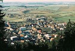 Podhradní Lhota seen from the Bašta hill | |
 Flag  Coat of arms | |
 Podhradní Lhota | |
| Coordinates: 49°25′18″N 17°47′39″E | |
| Country | |
| Region | Zlín |
| District | Kroměříž |
| Area | |
| • Total | 3.78 km2 (1.46 sq mi) |
| Elevation | 386 m (1,266 ft) |
| Population (2008) | |
| • Total | 519 |
| • Density | 140/km2 (360/sq mi) |
| Postal code | 768 71 |
The municipality covers an area of 3.78 square kilometres (1.46 sq mi), and has a population of 519 (as at 25 February 2008).
Podhradní Lhota lies approximately 33 kilometres (21 mi) north-east of Kroměříž, 23 km (14 mi) north-east of Zlín, and 254 km (158 mi) east of Prague.
Šaumburk Castle is located nearby.
This article is issued from Wikipedia. The text is licensed under Creative Commons - Attribution - Sharealike. Additional terms may apply for the media files.