Placerville, Colorado
Placerville is an unincorporated community and a U.S. Post Office located in San Miguel County, Colorado, United States. The Placerville Post Office has the ZIP Code 81430.[2]
Placerville, Colorado | |
|---|---|
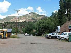 Front Street in Placerville | |
 Location in San Miguel County and the state of Colorado  Placerville, Colorado (the United States) | |
| Coordinates: 38°01′00″N 108°03′14″W | |
| Country | |
| State | |
| County | San Miguel[1] |
| Elevation | 7,320 ft (2,230 m) |
| Time zone | UTC-7 (MST) |
| • Summer (DST) | UTC-6 (MDT) |
| ZIP code[2] | 81430 |
| Area code(s) | 970 |
| GNIS feature ID | 0204743 |
History
Placerville was originally established as a small mining camp, named after the placer gold mines located on the San Miguel River and Leopard Creek. The location became known as Old Placerville after the Rio Grande Southern Railroad constructed a depot and several passing sidings west of the original settlement, calling it Placerville.
A. B. Frenzel discovered vanadium-bearing sandstone near Placerville in the late 1890s. The ore was in strataform bodies in the Entrada Sandstone (Jurassic) east of the town. The principal mineral was roscoelite, with minor montroseite and carnotite. By the fall of 1899, development was described as "of the most superficial character," although Frenzel had driven one tunnel 18 feet into the rock.[3] By 1901-1902, Frenzel was excavating several thousand tons intended for shipment to Europe.[4] Most of the Placerville ore was less than 3% vanadium, too low grade to pay for shipment to Europe, so in 1905 the Vanadium Alloys Co. built an ore-processing mill southeast of Placerville to recover the metal as ferro-vanadium, which it sold.[5] At least five mines were active at one time, and by 1919 the two ore mills at Placerville were producing 30% of the world's vanadium.[6] Through 1940, the mines produced about 3.7 million pounds of vanadium.[7]
Although carnotite was recognized as a minor constituent of the ore since its discovery, the amount was small, and no assays were made of the uranium content of the ore until World War II.[8] Beginning about 1950, the small uranium content of the ore was also recovered from the ore.[9]
Geography
Placerville is located at 38°01′00″N 108°03′14″W (38.016722,-108.053799).
Transportation
Placerville is part of Colorado's Bustang network. It is on the Durango-Grand Junction Outrider line.[10]
See also
| Wikimedia Commons has media related to Placerville, Colorado. |
- List of cities and towns in Colorado
- San Juan Mountains
- San Juan Skyway National Scenic Byway
References
- "US Board on Geographic Names". United States Geological Survey. 2007-10-25. Retrieved 2008-01-31.
- "ZIP Code Lookup" (JavaScript/HTML). United States Postal Service. January 2, 2007. Retrieved January 2, 2007.
- F. L. Ransome, Occurrence of the uranium and vanadium ores, American Journal of Science, Aug 1900, v.10, n.56, p.121-127.
- Harry E. Lee (1903) Report of the Colorado State Bureau of Mines for the Years 1901-1902, p.201.
- Frank L. Hess (1913) Notes on the vanadium deposits near Placerville, Colorado, in Contributions to Economic Geology, 1911, US Geological Survey, Bulletin 530, p.142-156.
- William L. Chenowith (1980) Uranium in Colorado, in Colorado Geology, Denver: Rocky Mountain Association of Geologists, p.217.
- R.P. Fischer and others (1947) Vanadium deposits near Placerville, San Miguel County, Colorado, Colorado Scientific Society Proceedings, v.15 n.3, p.120.
- A.L. Bush and others (1959) Areal geology of the Placerville Quadrangle, San Miguel County, Colorado, US Geological Survey, Bulletin 1072-E, p.373.
- R.P. Fischer (1968) Vanadium deposits of the Placerville area, San Miguel County, Colorado, in San Juan-San Miguel-La Plata Region, New Mexico and Colorado, New Mexico Geological Society, p.100-103.
- "Bustang Schedule". RideBustang. CDOT.
Municipalities and communities of San Miguel County, Colorado, United States | ||
|---|---|---|
| Towns | 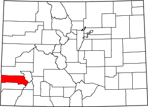 Map of Colorado highlighting San Miguel County | |
| Unincorporated communities |
| |
| Ghost town | ||