Place Charles de Gaulle
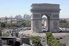 The Place Charles de Gaulle and Arc de Triomphe, with La Défense in the background | |
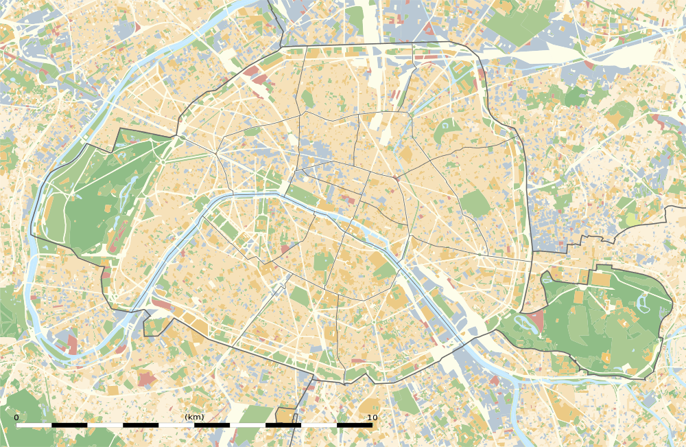 Shown within Paris | |
| Length | 240 m (790 ft) |
|---|---|
| Width | 240 m (790 ft) |
| Arrondissement | 8th, 16th, 17th |
| Quarter | Champs Elysées, Faubourg du Roule, Chaillot, Ternes. |
| Coordinates | 48°52′26″N 2°17′41″E |
| Construction | |
| Completion | 1670 |
| Denomination | 13 November 1970 |
The Place Charles de Gaulle (French: [plas ʃaʁl də ɡol]), historically known as the Place de l'Étoile (French: [plas də letwal]), is a large road junction in Paris, France, the meeting point of twelve straight avenues (hence its historic name, which translates as "Square of the Star") including the Champs-Élysées. It was renamed in 1970 following the death of President Charles de Gaulle. It is still often referred to by its original name; the nearby Métro and RER station retains the designation Charles de Gaulle–Étoile. Paris's Axe historique ("historical axis") cuts through the Arc de Triomphe, which stands at the centre of the Place Charles de Gaulle.
History
The original name of the area was the Butte Chaillot ("Chaillot mound", named after the locality). At the time it was the point of convergence of several hunting trails. The Marquis de Marigny constructed monumental roadworks, completed in 1777, on the mound when he was establishing the plantations along the Champs-Élysées. This work included paving of the road in the form of a star, as it still exists today. The junction became known as the Place de l'Étoile. Pedestrian access to the Arc de Triomphe itself is via pedestrian underpass, to avoid the confluence of vehicular traffic from the juncture of twelve radiating avenues.
In 1787, during the construction of the Farmers-General Wall (Mur des Fermiers généraux), la Barrière de l'Étoile (also known as the Barrière de Neuilly) was built to the design of Claude Nicolas Ledoux for the collection of the octroi tax at the entrance to Paris. The wall and the two buildings built on either side of the Place de l'Étoile were demolished in the nineteenth century. The modern Place Charles de Gaulle and the avenues radiating from it were created during the Second French Empire of Napoleon III as part of Haussmann's renovation of Paris.[1]
Description
Map
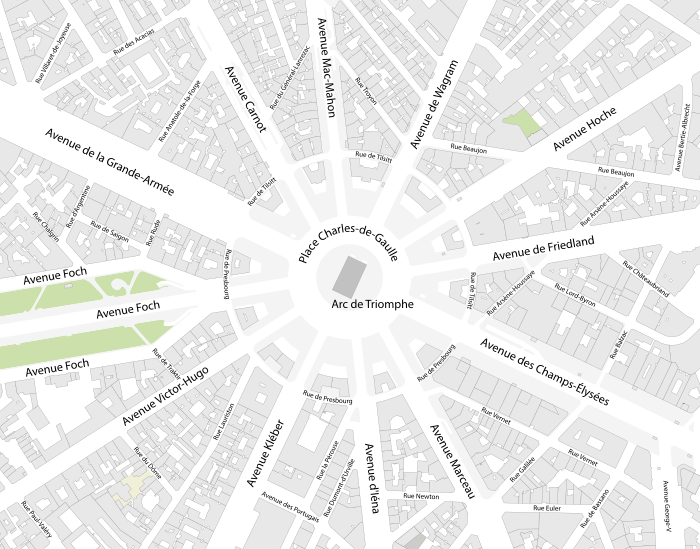
Avenues

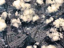
The twelve avenues, clockwise from the north, are the following:
- Avenue de Wagram (thus called since the Second Empire) and Boulevard de l'Étoile or Boulevard Bezons before
- Avenue Hoche: Avenue de la Reine-Hortense during the Second Empire and Boulevard Monceau before
- Avenue de Friedland since the Second Empire and Boulevard Beaujon before
- Avenue des Champs-Élysées
- Avenue Marceau: Avenue Joséphine during the Second Empire
- Avenue d'Iéna
- Avenue Kléber: Avenue du Roi-de-Rome during the Second Empire and Boulevard de Passy before
- Avenue Victor Hugo: Avenue d'Eylau during the Second Empire and Avenue de Saint-Cloud before
- Avenue Foch: Avenue du Bois during the Third Republic and Avenue de l'Impératrice during the Second Empire
- Avenue de la Grande-Armée during the Second Empire and Avenue de Neuilly before
- Avenue Carnot: Avenue d'Essling during the Second Empire
- Avenue Mac-Mahon: Avenue du Prince-Jérôme during the Second Empire
The square is surrounded by two streets forming a circle around it: the Rue de Presbourg and Rue de Tilsitt, which have been so named since 1864, after diplomatic successes of Napoleon which led to the signing of the Treaty of Presbourg in 1805 and the Treaties of Tilsit in 1807.
Axes

The Place Charles de Gaulle is symmetrical and thus has six axes:
- Axis Avenue Mac-Mahon and Avenue d'Iéna
- Axis Avenue de Wagram and Avenue Kléber
- Axis Avenue Hoche and Avenue Victor-Hugo
- Axis Avenue de Friedland and Avenue Foch
- Axis Avenue des Champs-Élysées and Avenue de la Grande-Armée which is the Axe historique of Paris
- Axis Avenue Marceau and Avenue Carnot
Arrondissements

The Place Charles de Gaulle (as well as the Arc de Triomphe) is split between the 8th, 16th and 17th arrondissements of Paris. The 8th arrondissement encompasses the area between Avenue de Wagram and Avenue Marceau. The 16th arrondissement encompasses the area between Avenue Marceau and Avenue de la Grande-Armée. The 17th arrondissement encompasses the area between Avenue de la Grande Armée and Avenue de Wagram.
Literature
La Place de l'étoile is the title of a novel by French writer Patrick Modiano.
Transportation

- Located near the Métro station: Charles de Gaulle–Étoile.
The square is served by Métro and RER services. Line 1, as well as RER A, run under the Avenue de la Grande-Armée and Champs-Élysées and stop at the station; it also serves as western terminus for Line 2 and Line 6.
References
- de Moncan, Patrice, Le Paris de Haussmann, Les Editions du Mecene, 2012 (ISBN 978-2-9079-70983)
External links
![]()