Pinos Altos Historic District
The Pinos Altos Historic District is a historic district which was listed on the National Register of Historic Places in 1984. It includes 37 contributing buildings on 72 hectares (180 acres).[1]
Pinos Altos Historic District | |
 | |
| Location | Roughly bounded by Gold Ave. and Cherry, Main, Church, and Silver Sts., Pinos Altos, New Mexico |
|---|---|
| Coordinates | 32°51′58″N 108°13′09″W |
| Area | 72 hectares (180 acres) |
| Built | 1860 |
| NRHP reference No. | 84002945[1] |
| Added to NRHP | May 21, 1984 |
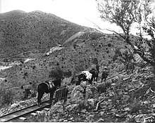
Pinos Altos Railroad
It is roughly bounded by Gold Ave. and Cherry, Main, Church, and Silver Streets.
It was a gold camp in the 1800s. It is located on the Continental Divide, at elevation 7,067 feet (2,154 m), in the Pinos Altos Mountains. The first house there was built in 1860, had a dirt roof, and still survived in 1929.[2]
Two log buildings, both built of square hewn logs, are in the district:
- the Pinos Altos School, on Main Street, the first school in Pinos Altos, assertedly built in 1866
- the John McDonald cabin, on Spring Street, also probably built in the 1860s.[2]
References
- "National Register Information System". National Register of Historic Places. National Park Service. November 2, 2013.
- Susan Berry (August 1982). "National Register of Historic Places Inventory/Nomination: Pinos Altos Historic District". National Park Service. Retrieved July 28, 2019. With accompanying nine photos from 1982
| Topics | |
|---|---|
| Lists by state |
|
| Lists by insular areas | |
| Lists by associated state | |
| Other areas | |
| Related | |
| |
This article is issued from Wikipedia. The text is licensed under Creative Commons - Attribution - Sharealike. Additional terms may apply for the media files.