Pilica, Masovian Voivodeship
Pilica [piˈlit͡sa] is a village in the administrative district of Gmina Warka, within Grójec County, Masovian Voivodeship, in east-central Poland.[1] It lies approximately 4 kilometres (2 mi) north-east of Warka, 28 km (17 mi) east of Grójec, and 50 km (31 mi) south of Warsaw.
Pilica | |
|---|---|
Village | |
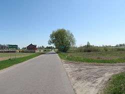 Entering Pilica from Stara Warka | |
 Pilica | |
| Coordinates: 51°48′30″N 21°15′30″E | |
| Country | |
| Voivodeship | Masovian |
| County | Grójec |
| Gmina | Warka |
| Population | 210 |
The village has a population of 210 and lies on the higher, left bank of the Pilica River, about 9 km upstream from where it now joins the Vistula. In the Middle Ages, the settlement's location on the western scarp of the Vistula River valley marked the then confluence of the two rivers, resulting in the village sharing the name of the river;[2] however there is another small town also called Pilica, which lies near the source of the same river.
During World War II the area was heavily fought over and the village was in the front line for five months from the beginning of August 1944 when the Soviet army established a strategic bridgehead at Magnuszew on the west bank of the Vistula, followed by German counterattacks, until the successful Soviet breakout on 12 January 1945.
References
- "Central Statistical Office (GUS) – TERYT (National Register of Territorial Land Apportionment Journal)" (in Polish). 2008-06-01.
- Official Tourist Website of Mazovia > The surroundings of Warka Accessed 30 July 2012.
Historical photos
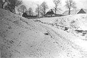 Houses in Pilica, c.1939
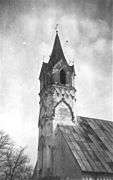 Spire of Evangelical Lutheran church (Kościół Ewangelicko-Augsburski) in Pilica, c.1939
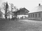 Evangelical Lutheran church and manse in Pilica, c.1939