Pett
Pett is a village and civil parish in the Rother district of East Sussex, England. The village is located 5 miles (8.0 km) north-east of Hastings on the edge of Pett Level, the one-time marshes stretching along the coast of Rye Bay.[3]
| Pett | |
|---|---|
 St Mary and St Peter's Church, Pett | |
 Pett Location within East Sussex | |
| Area | 6.5 km2 (2.5 sq mi) [1] |
| Population | 846 (Parish-2011)[2] |
| • Density | 311/sq mi (120/km2) |
| OS grid reference | TQ873139 |
| • London | 54 miles (87 km) NW |
| District | |
| Shire county | |
| Region | |
| Country | England |
| Sovereign state | United Kingdom |
| Post town | HASTINGS |
| Postcode district | TN35 |
| Dialling code | 01424 |
| Police | Sussex |
| Fire | East Sussex |
| Ambulance | South East Coast |
| UK Parliament | |
- PETT is also an abbreviation for the Kamchatka Time Zone in Russia.
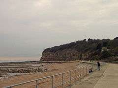
The road through the village leads down to the second village in the parish: Pett Level, the coastal part of which is known as Cliff End. Here there is a beach and, as the name suggests, the Weald sandstone cliffs reach their easternmost point. Pett Level marks the end of both the Royal Military Canal and the western end of the 1940s sea defence wall.[3] The Saxon Shore Way passes through Pett Level.[4] Pett parish church is dedicated to St Mary and St Peter.[5] Pett also has a Methodist chapel,[6] and a small Church of England church at Cliff End.[5]
History
The manor of Pett belonged to a succession of families, including the Halle family, the Levett family, the Fletchers and the Medleys, before eventually passing to the Earls of Liverpool.[7]
Landmarks
There is a Site of Special Scientific Interest partly within the parish. Hastings Cliffs to Pett Beach runs along the coast and is of both biological and geological interest. The cliffs hold many fossils and have many habitats, including ancient woodland and shingle beaches.[8] These include a sunken forest, a warship which is thought to have sank in 1690, a lost series of Martello towers and at Cliff End the beach has some fossils and some dinosaur footprints from the Lower Cretaceous.[9]
In popular culture
Pett Level beach was the filming location for parts of the video of David Bowie's 1980 number one hit single "Ashes to Ashes."[10]
References
- "East Sussex in Figures". East Sussex County Council. Retrieved 26 April 2008.
- "Civil Parish population 2011". Retrieved 7 October 2015.
- "Pett Level". Pett Level. Retrieved 19 March 2020.
- "Hastings to Pett Level walking on beach". ViewRanger. Retrieved 19 March 2020.
- "Fairlight & Pett Churches". Fairlight & Pett Churches. Retrieved 19 March 2020.
- "Pett Methodist Chapel". Pett Methodist Chapel. Retrieved 19 March 2020.
- Mark Antony Lower (1870). A Compendious History of Sussex.
- SSSI Citation — Hastings Cliffs to Pett Beach (PDF) (Report). Natural England. Retrieved 13 October 2008.
- Tanya Gupta (14 August 2013). "'Little known' about ancient Pett Level sunken forest". BBC. Retrieved 19 March 2020.
- Pegg, Nicholas (2011). The Complete David Bowie (6th ed.). London: Titan Books. p. 30. ISBN 9780857682901.CS1 maint: ref=harv (link)