Peaceburg, Alabama
Peaceburg is an unincorporated community in Calhoun County, Alabama, United States.
Peaceburg, Alabama | |
|---|---|
 Peaceburg, Alabama  Peaceburg, Alabama | |
| Coordinates: 33°44′22″N 85°54′38″W | |
| Country | United States |
| State | Alabama |
| County | Calhoun |
| Elevation | 666 ft (203 m) |
| Time zone | UTC-6 (Central (CST)) |
| • Summer (DST) | UTC-5 (CDT) |
| Area code(s) | 256 & 938 |
| GNIS feature ID | 156861[1] |
History
A post office was established in the former town of Peaceburg, Alabama, in 1885, and remained in operation until it was discontinued in 1905.[2] Peaceburg (as well as the nearby town of Morrisville) was part of a purchase of 26,912.17 acres by the War Department in 1941. The area was evacuated by its residents and served the purpose of training for World War II. Originally it was called the Morrisville Maneuver Area but later was renamed as the Pelham Range Area.[3][4]
Peaceburg has been noted for its unusual place name.[5]
Its coordinates are approximately 33.738268 degrees north and -85.904732 degrees west, located in west central Calhoun County, in Alabama, at an altitude of 620 feet.
References
- "Peaceburg". Geographic Names Information System. United States Geological Survey.
- "Calhoun County". Jim Forte Postal History. Retrieved 8 October 2014.
- https://www.nytimes.com/1940/11/24/archives/peaceburg-yields-to-armys-spread-alabama-folk-sadly-accept-call-to.html
- https://www.nrc.gov/docs/ML0527/ML052700341.pdf
- Thompson, George E. (1 July 2009). You Live Where?: Interesting and Unusual Facts about where We Live. iUniverse. p. 3. ISBN 978-1-4401-3421-0.
Municipalities and communities of Calhoun County, Alabama, United States | ||
|---|---|---|
| Cities | 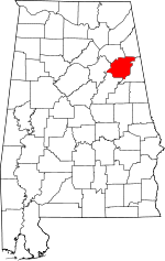 Map of Alabama highlighting Calhoun County | |
| Towns | ||
| CDPs | ||
| Unincorporated communities | ||
| Ghost town | ||
| Footnotes | ‡This populated place also has portions in an adjacent county or counties | |