Payer Island
Payer Island (Russian: остров Пайера, romanized: ostrov Payera) is an island in Franz Josef Land, Russia.
| Native name: остров Пайера | |
|---|---|
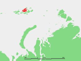 Location of the Zemlya Zichy subgroup in Franz Josef Land | |
 Payer Island | |
| Geography | |
| Location | Arctic Ocean |
| Coordinates | 80.58°N 60.5°E |
| Archipelago | Franz Josef Land |
| Area | 151 km2 (58 sq mi) |
| Length | 20 km (12 mi) |
| Width | 12.5 km (7.77 mi) |
| Highest elevation | 452 m (1,483 ft) |
| Highest point | Kupol Frolova |
| Administration | |
| Oblast | Arkhangelsk Oblast |
| Demographics | |
| Population | 0 |
This island was named after Julius Johannes Ludovicus von Payer an Austro-Hungarian arctic explorer and an Arctic landscape artist, one of the leaders of the Austro-Hungarian North Pole Expedition.
Geography
Payer Island is part of the Zichy Land subgroup of the Franz Josef Land. Its area is 151 km² and it lies to the SE of Jackson Island. The headland at the northern end is Mys Nordik.[1] The center of the island is covered by an ice dome named Kupol Frolova (Купол Фролова). Its highest point reaches 452 m (1,483 ft).[2]
Adjacent islands
Very close to Payer Island, off its easternmost point, lie some small islands:
- Stoliczka Island (Остров Столичка), the island farther offshore, is the site of a large walrus rookery. Lat 81° 11′ N, long 58° 16′ E. This island was named after Moravian paleontologist Ferdinand Stoliczka (1838–1874) by the Austro-Hungarian North Pole Expedition.
- Apollo Island (Ostrov Apollonova) lies in the sound between Stoliczka and Payer Island. It is only 500 m across.
- Milovzorov Rocks (Рифы Миловзорова), rocks awash located off the NE shore of Payer Island.
See also
- List of islands of Russia
- List of glaciers of Russia
Bibliography
- Clements R. Markham, The Lands of Silence
References
- "Ostrov Payyera". Mapcarta. Retrieved 7 October 2016.
- Kupol Frolova - Map, Weather and Photos - Russia
This article is issued from Wikipedia. The text is licensed under Creative Commons - Attribution - Sharealike. Additional terms may apply for the media files.