Patea
Patea (/pɑːˈtɛər/ pah-TAIR) is the third-largest town in South Taranaki, New Zealand. It is on the western bank of the Patea River, 61 kilometres north-west of Whanganui on State Highway 3. Hawera is 27 km to the north-west, and Waverley 17 km to the east. The Patea River flows through the town from the north-east and into the South Taranaki Bight.[2][3] In the 2013 census, the population was 1,098 people, a decrease of 42 people since the 2006 Census.[4]
Patea | |
|---|---|
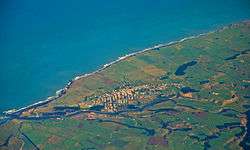 Aerial photo of Patea | |
 Patea | |
| Coordinates: 39°45′26″S 174°28′36″E | |
| Country | New Zealand |
| Region | Taranaki |
| District | South Taranaki District |
| Population (June 2019)[1] | |
| • Total | 1,160 |
| Postcode(s) | 4520 |
History and culture
European settlement
Patea, called Carlyle or Carlyle Beach for a time by European settlers, was originally nearer the Patea River mouth than the present town. During the New Zealand Wars Patea was an important military settlement. General Cameron's force arrived at the river mouth on 15 January 1865 and constructed redbouts on both sides of the river.[5]
Patea became a market town when hostilities ended. The first of the sections on the present town site were sold in 1870. A local shipping company was established in 1872, and harbour improvements began. The Marton-New Plymouth railway line via Patea was completed in March 1885. The Carlyle Town Board, created about 1877 to administer town affairs, was succeeded by a borough council constituted on 13 October 1881 under the name Patea.[6]
In the 1920s Patea was the largest cheese exporting port in the world. The Grader Cool Store received cheese for grading from all over South Taranaki and as far south as Oroua Downs near Himatangi. After grading it was loaded into coastal ships at the grader wharf for transport to Wellington where it was transhipped into overseas ships for export. The port closed in July 1959.
Patea Freezing Works
In the early 1880s the predecessor to the Patea Freezing Works was established on the eastern bank of the Patea River. Cool stores for handling dairy produce followed in 1901 with later additions evolving into what became known as the Patea Freezing Co-Op, South Taranaki's primary employer. Strategic reforms, inefficiencies and nationwide over-processing resulted in closure in September 1982. In February 2008 the derelict buildings suffered severe fires. The damage was extensive and with the health hazard presented by asbestos insulation throughout the freezer walls, the town sought demolition.
Patea Māori Club
Patea became known in 1984 as the home of singer Dalvanius Prime and the Patea Māori Club. Their single, "Poi E", indicated renewed impetus in contemporary Māori popular music.[7]
Recent history
Patea has retained a strong community focus and enjoys many services including a well-resourced medical centre, public swimming pool and trust-owned rest home. The town is also the location of Aotea Utanganui - Museum of South Taranaki.
The breakwaters at Patea were started in 1878 and are being refurbished by the South Taranaki District Council.
Patea and surrounding community has a South Taranaki District Council LibraryPlus, which provides a full library service and Council-related services, including dog registration, payment of rates, and building permit enquiries. Other services include a Tot Time for the under 5s, a regular crossword morning and a book club for intermediate and high school children. The LibraryPlus has six APN computers, offering free internet and Skype.
Several kilometres east of Patea is the small community of Whenuakura, where New Zealand golfer Michael Campbell lived as a child. He learned to play golf at the Patea Golf Club, on the cliffs overlooking the Tasman Sea. He crowned his professional career by winning the U.S. Open in June 2005, and three months later the HSBC World Match Play Championship.
Marae
The local Wai o Turi marae and Rangiharuru meeting house are affiliated with the Ngā Rauru hapū of Rangitāwhi.[8][9]
Education
Patea Area School is a composite (years 1-13) school with a roll of 170.[10] Until 2005 the school was Patea High School. It became an area school when Patea Primary School closed.[11] The primary school was founded in 1875.[12]
St Joseph's School is a state integrated Catholic contributing primary (years 1-6) school with a roll of 34.[13] The school was established in January 1904.[14]
Both schools are coeducational and have a decile rating of 1.
References
- "Subnational Population Estimates: At 30 June 2019". Statistics New Zealand. 22 October 2019. Retrieved 11 January 2020.
- Peter Dowling (editor) (2004), Reed New Zealand Atlas, Reed Books, map 44, ISBN 0-7900-0952-8CS1 maint: extra text: authors list (link)
- Roger Smith, GeographX (2005), The Geographic Atlas of New Zealand, Robbie Burton, map 97, ISBN 1-877333-20-4
- 2013 Census QuickStats about a place : Patea
- South Taranaki District Council Heritage files (Local Government Historical Body)
- Historical Settlements: From Whanganui to New Plymouth—N.J Taniwha—Wanganui—summary 2001 1st year 1997 subm. Political Essay—Infrastructure—Patea Freezing Works Government deregulation and asset assumption—A political agenda. National Congress Lib. Washington USA
- "Interview with Syd and Hui Kahu from Patea Maori Club".
- "Te Kāhui Māngai directory". tkm.govt.nz. Te Puni Kōkiri.
- "Māori Maps". maorimaps.com. Te Potiki National Trust.
- "Te Kete Ipurangi - Patea Area School". Ministry of Education.
- "Education Review Report: Patea Area School". June 2006.
- Baker, Ngaere (1975), Patea Primary School centennial, 1875-1975
- "Te Kete Ipurangi - St Joseph's School, Patea". Ministry of Education. Archived from the original on 2003-05-29.
- "School History". St Joseph's School. Archived from the original on 2007-07-23.