Pass of Killiecrankie
Three miles north of Pitlochry by the A9 road, the Pass of Killiecrankie (Gaelic: Coille Chneagaidh), is a gorge lying between 2757 ft (830 m) Ben Vrackie and Tenandry Hill in Perth and Kinross on the River Garry.[1]
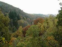
The river-gorge traverses the pass over the course of a mile, and above it, the road and the railway, with the village of Killiecrankie at the north end. Much of the area is owned by the National Trust for Scotland.[2]
About a mile toward the village of Killiecrankie, the Battle of Killiecrankie took place in 1689.[3]
There was also a ship, a 3 masted bark named the Pass of Killiecrankie of the Killiecankie line. The ship was later renamed Stifinder. Picture of ship.
Killiecrankie is part of the Loch Tummel National Scenic Area (NSA),[4] one of 40 such areas in Scotland, which are defined so as to identify areas of exceptional scenery and to ensure its protection by restricting certain forms of development.[5]
Footnotes
- Google map
- "Killiecrankie". Natural Trust for Scotland. Retrieved 17 January 2018.
- "Killiecrankie, Tenandry and Strathgarry". Tour Scotland. Archived from the original on 16 January 2013. Retrieved 18 December 2007.]
- "Map: Loch Tummel National Scenic Area" (PDF). Scottish Natural Heritage. December 2010. Retrieved 2 May 2018.
- "National Scenic Areas". Scottish Natural Heritage. Retrieved 17 January 2018.
External links
| Wikimedia Commons has media related to Pass of Killiecrankie. |