Partium
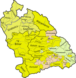
Partium[1] (from Latin partium, the genitive of pars "part, portion") or Részek (in Hungarian) was a historical and geographical region in the Kingdom of Hungary during the early modern and modern periods. It consisted of the eastern and northern parts of Hungary proper.[note 1] At times, it included Miskolc, and Kassa (today Košice, Slovakia) (see map).
History

In 1526, after the Battle of Mohács, the Kingdom of Hungary was overrun by the Ottomans, but effectively split into 3 parts in 1541 when the Ottomans captured Buda. The Habsburgs got a foothold in the north and west (Royal Hungary), with the new capital Pressburg (Pozsony, today's Bratislava). King John I of Hungary from the Zápolya house, the former voivode of Transylvania and the wealthiest and the most powerful landlord after Mohács, secured the eastern part of the Kingdom (referred as Eastern Hungarian Kingdom by Hungarian scholars) with the help of the Ottomans. On 29 February 1528, the sultan assented to an alliance with Zápolya and gave written assurance of his support.
From 1541 or 1542, the house of Zápolya also controlled the region that after 1571 became known as Partium.
In 1570, John II Sigismund Zápolya, son of John I Zápolya renounced his claim as King of Hungary (1540-1570) in favour of Maximilian II of Habsburg, who also claimed the title since 1563. Instead John II Sigismund Zápolya remained Prince of Transylvania between 1570 and 1571.
In 1570, by the Treaty of Speyer (Spires), John II Sigismund, John I's son, abdicated as king of Hungary, and a new dukedom was invented for him: "Joannes, serenissimi olim Joannis regis Hungariae, Dalmatiae, Croatiae etc. filius, Dei gratia princeps Transsylvaniae ac partium regni Hungariae" (John, son of the late most serene king John of Hungary, Dalmatia, Croatia, etc., by the grace of God prince of Transylvania and parts of the Kingdom of Hungary), from which derives the name Partium.
This treaty, like the earlier Nagyvárad accord, endorsed the principle of a united Hungary. Partium and Transylvania were entrusted to John II Sigismund, but under the title of imperial prince. As mentioned above, the Zápolya held Partium before, but the treaty allowed them to do this without fear that the Habsburgs would contest the house of Zápolya's lordship. In a sense, Zápolya traded title for territory.
The Eastern Hungarian Kingdom ceased to exist, and became simply the Principality of Transylvania. All rulings after 1570 as King of Hungary refer to the territory known as "Royal Hungary", and as Prince refer to the Principality of Transylvania which included Partium.
For some decades during the 17th century Partium was part of the Principality of Transylvania, and consequently a part of the Ottoman Empire.[2] On 5 September 1619, the prince of Transylvania, Gabriel Bethlen captured Kassa (now Košice) in Partium Abaúj County with the assistance of the future George I Rákóczi in another anti-Habsburg insurrection. By the Peace of Nikolsburg in 1621, the Habsburgs restored the religious toleration agreement of 1606 and recognized Transylvanian rule over seven stated Partium counties: Ugocsa, Bereg, Zemplén, Borsod, Szabolcs, Szatmár and Abaúj.[3]
These were returned to Habsburg Royal Hungary at Bethlen's death in 1629, but were once again seized by Transylvanian prince George I Rákóczi in 1644 and formally ceded by Habsburg Royal Hungary to Transylvania at the Treaty of Linz (1645).[4]
Geographic extent
Initially, Partium consisted of the counties of Máramaros, Közép-Szolnok, Kraszna, and Bihar, as well as the Kővárvidék. The Banate of Severin and eastern Zaránd, that was already part of John II Sigismund’s realm, were also included in what was named Partium. These territories were ruled by Transylvania, but were not formally part of the Principality (later Grand Principality) of Transylvania, and so the name Partium was coined.
All of Transylvania was at the time under permanent threat of being overrun by both Habsburgs and Ottomans. Partium was taken by the Ottoman troops in 1660, but was back in Transylvanian possession by the end of the century, when the latter was absorbed in the Habsburgs' domain in 1687 (de facto) / 1699 (by treaty with the Ottomans).
In the 18th century, the name was used to describe a smaller area, consisting of Közép-Szolnok, Kraszna, the Kővárvidék, and a rump Zaránd, but was not itself an official subdivision.
In 1867, at the Ausgleich, the Partium territories were incorporated into the Transleithanian part of Austria-Hungary. (See comitatus system.)
Present-day location
With the dissolution of the Austro-Hungarian Empire at the end of World War I, Partium was split, under to the terms of the 1920 Treaty of Trianon, among the successor states of the former Kingdom of Hungary: about 60% became part of Romania, about 20% - part of Hungary, and about 20% - part of Czechoslovakia. The latter part, known as Carpathian Ruthenia, was ceded to Soviet Union after World War II and since 1991 belongs to Ukraine.

The Romanian part roughly corresponds to the Crişana and partly Banat regions of Romania. The Hungarian part corresponds to the Hajdú-Bihar county, and small parts of the Szabolcs-Szatmár-Bereg and Békés counties of Hungary. The Ukrainian part corresponds to the Northern Maramuresh (geographic region) of the Zakarpattia Oblast, Ukraine.
In present-day Hungarian usage, Partium chiefly refers to the part of the region that lies in Romania.
Autonomy initiatives
With the support of Hungarian People's Party of Transylvania, which advocates territorial autonomy for Partium,[5][6] the Council for Autonomy in Partium was created in 2013.[7] The Council approved a new flag for Partium in 2015 composed of a Patriarchal cross and Árpád stripes, both traditional symbols of the Hungarian nation featured on the coat of arms of Hungary.
Notes
- During the early modern period, Hungary was divided and Transylvania, despite being part of the Lands of the Hungarian Crown, was recognized as a distinct polity. The reunification of Transylvania and "Hungary proper" happened in 1868.
References
- Kees Teszelszky, A Divided Hungary in Europe: Exchanges, Networks and Representations, 1541-1699; Volume 3 – The Making and Uses of the Image of Hungary and Transylvania, Volume 3., Cambridge Scholars Publishing, 2015, p. IX (Preface)
- Papp, Sandor. "Slovakya'nın Tarihi". TDV İslam Ansiklopedisi. 33: 337. Retrieved 24 April 2016.
- Hötte, Hans H. A. (2014-12-17). Atlas of Southeast Europe: Geopolitics and History. Volume One: 1521-1699. ISBN 9789004288881.
- Hötte, Hans H. A. (2014-12-17). Atlas of Southeast Europe: Geopolitics and History. Volume One: 1521-1699. ISBN 9789004288881.
- "Megalakult a Partiumi Autonómia Tanács". kitekinto.hu. 22 July 2013. Retrieved 20 June 2014.
- "Nyílt pályázat a Partium jelképeinek megtervezésére". erdely.ma. 21 May 2013. Archived from the original on 1 July 2014. Retrieved 20 June 2014.
- http://www.agerpres.ro/comunicate/2015/10/17/comunicat-de-presa-partidul-popular-maghiar-din-transilvania-16-25-55