Park Street, Hertfordshire
Park Street is a small Hertfordshire village[n 1] near St Albans; it is separated from the small city by a buffer to the north.
| Park Street | |
|---|---|
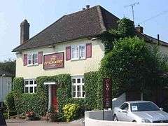 One of the two remaining public houses, both of which have restaurants | |
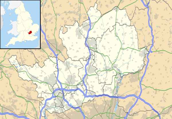 Park Street Location within Hertfordshire | |
| Population | 6,781 (2001 census – whole ward) |
| OS grid reference | TL148040 |
| Civil parish | |
| District | |
| Shire county | |
| Region | |
| Country | England |
| Sovereign state | United Kingdom |
| Post town | ST ALBANS |
| Postcode district | AL2 2 |
| Dialling code | 01727 (87) |
| Police | Hertfordshire |
| Fire | Hertfordshire |
| Ambulance | East of England |
| UK Parliament | |
Park Street has a petrol station, several tyre and automotive service businesses and two food-serving public houses; it is of late and initially disparate medieval origin.[1] The village is also home to the penultimate station on the Abbey Line from Watford Junction, which opened in 1858.
Park Street is also a larger local government ward (the largest settlement of which is How Wood and which includes part of Bricket Wood). The area falls within the Metropolitan Green Belt. Residents are mainly employed in nearby cities; however, the sixth-largest pub group in the United Kingdom, the Orchid Group, which specialises in dining, uses the converted mill house in the village,[2] and east of the street in Frogmore is a substantial business centre and light industrial estate.
Location
Park Street is approximately 2½ miles by road from St Albans via Watling Street (the old Roman road from London to Chester and Holyhead) and then a post-Roman offshoot, St Stephen's Hill, into the medieval city centre.
Just south of the A405/A414 North Orbital Road, Hertfordshire which has a direct spur to the M25 (J21A) and Watford, the A405, road links and rail links are within the village boundaries.
The A405, A414, A5183 (formerly A5, Watling Street) and the former M10 motorway (now numbered as part of the A414 as of 1 May 2009), join at Park Street Roundabout. This was featured for many years in the road signs section of the Highway Code.
To the east and south-east of the village lies the disused Handley Page aerodrome.
Origin of the name
It is thought unlikely the name 'Park' comes from the usual meaning of an enclosure of land for the purpose of hunting but rather simply designates an enclosure of some kind derived from the Saxon word for enclosure which is ‘pearroc’.
The village lies on the Roman Road of Watling Street which forms the main street and continued as a trunk route for travellers going to and from the north from London during Saxon and Norman times.[3]
History
The immediate village has fourteen heritage-listed buildings (one of which is half-timbered) on Watling Street – the majority of the rest being brick built early Victorian buildings – though Toll Cottage on Bury Dell just to the east is 17th century.[4] Most significantly to this area would have been the passing trade for villagers to sell their ale and produce along Watling Street and easy access to the markets in the nearby pre-Roman settlement, see History of St Albans.
Queen Elizabeth I's spy master Sir Francis Walsingham lived at nearby Old Parkbury, south of the village which was the manor house.[5]
There used to be a Sub Post-Office and more shops, however both How Wood and St Albans provide a larger range of shops.
Landmarks
The main landmark in the village is a Mill, which was converted into offices in 1984. During the conversion a World War II bomb was found in the "Old Smithy's" garden.
There is a Village Hall, accessed from the A5183. Opened in 1936 it is the polling station.
Park Street Baptist Church is on Penn Road.
Railway station

Park Street railway station is the first station after St Albans Abbey on the St Albans Branch Line. The train service on this line is known locally as the 'Abbey Flyer'. The railway was built in 1858 as a branch line from the London & Birmingham Railway, and Park Street station has been on its current site since 1890. Before being moved to its current position, on Watling Street, it was situated just near Hyde Lane off Park Street Lane, near the current How Wood station.
There was another railway line, built in 1866, which linked the above London and North Western Railway branch line to St Albans, to the newly constructed Midland Railway's main line from Bedford to St Pancras, at Napsbury. It was a goods line in brief use, closed by 1910, called the Park Street Branch and was operated by the Midland Railway. The railway bridge near Sycamore Drive was demolished around 1948 after being damaged by a giant propellor being delivered to the Handley Page aircraft works. It is still possible to see some of the bridge brickwork here which is just by 'The Overdraught' pub. Another, over the River Ver at the back of Sycamore Drive still survives. Beyond the bridge over the River Ver this line crossed what became the Handley Page aircraft factory runway. This runway was in use until the mid-1960s for the maintenance and testing of the V bomber fleet.
A 1960s metal bridge carries the Abbey Line trains, sometimes affectionately dubbed the Abbey Flyer, over the main road, replacing a previous brick one.
Schools
Park Street has two primary schools, Park Street Church of England Primary School[6] and How Wood Primary School.[7]
The nearest secondary school is Marlborough School,[8] near the 'King Harry' public house in St Albans.
Public houses
There are just two pubs in the village: The Falcon and The Overdraught. There were previously seven other pubs in Park Street/Frogmore/Colney Street: 'The Red Lion' closed in 2009, and 'The Swan' closed in 2008. In Frogmore, 'The Red Cow' closed 2001/02, and 'The Lamb' closed in the early 1970s. In Colney Street there used to be three pubs: 'The Black Horse', which was demolished in 2003; 'The George and Dragon', which closed in the early 1990s; and 'The Jolly Farmer', which closed in the 1930s.
'The Overdraught' used to be called 'The White Horse'.
Until the early 1970s, 'The George & Dragon' was situated opposite the entrance to Handley Page aircraft factory. Once the factory closed the last landlord couldn't make a living and, so legend has it, he and his wife closed the pub, locked themselves in and drank the pub dry before being ordered out by the brewery. The pub's building still exists as a private residence.
'The Lamb's' building still stands, almost opposite the Holy Trinity Church. It is now divided into 3 flats.
The Falcon is reputed to be on the site of a "Pilgrim's Rest", which was a series of places to house the pilgrims to St Alban's shrine in the 1600s.
Parks and sport
Park Street has three parks:
- Recreation Ground by sports fields on Park Street Lane: Park Street Football Club and the cricket (sport) ground and pavilion.
- Mayflower Road Park
- Frogmore Lakes Park, to the south of the village just past the gravel pits, popular for fishing.
There also used to be a big park along Burydell/ Bury Dell Lane, replaced by the vegetable allotments, this was in use at least until 1900.
Nearest Settlements | ||||||||||
|---|---|---|---|---|---|---|---|---|---|---|
| ||||||||||
Notes
- The population relates to all of the local government ward; see ward map for population at statistics.neighbourhood.gov.uk
References
- Park Street's nearby Anglican church of the Holy Trinity, originally simply named 'a chapel of ease to St Stephen' was built in 1841-2 is in the heart of Frogmore but was according to the listing entry research by English Heritage built to serve the more than 2000 scattered parishioners of the 4 miles (6.4 km) by 5 miles (8.0 km) parish of St Stephen, St Albans, where only 3 poor outlying cottages were within one mile of St Stephens, now a close suburb of St Albans in the 1840s, see Historic England. "Details from listed building database (1347115)". National Heritage List for England. Retrieved 25 August 2012. Holy Trinity Church, on the Frogmore border
- Pub explorer website
- Ver Valley Society (2017). "Memories of the Ver" (PDF). Society web pages.
- Historic England. "Details from listed building database (1103170)". National Heritage List for England. Retrieved 25 August 2012.
- Sheilds, Pamela (2009). Hertfordshire Secrets and Spies. Stroud: Amberley. p. 22. ISBN 9781848687882.
- "Park Street – Church of England Primary School". Parkstreetprimary.org.uk. Retrieved 3 April 2017.
- "How Wood Primary School | Welcome". Howwood.herts.sch.uk. Retrieved 3 April 2017.
- "Archived copy". Archived from the original on 15 March 2013. Retrieved 29 December 2012.CS1 maint: archived copy as title (link)
- Historic England. "Details from listed building database (1001400)". National Heritage List for England. Retrieved 19 August 2012.
External links

| Authority control |
|
|---|