Parauapebas
Parauapebas is a municipality in the state of Pará in the Northern region of Brazil.[1] [2] [3] [4] [5]
Parauapebas | |
|---|---|
Municipality | |
.svg.png) Flag | |
| Nickname(s): "Pebas" "Cidade dos Paraensses" [Town of the people from Pará] (even though it is in Pará: a town of immigrants) | |
| Motto(s): Vis et Labore "Força e Trabalho" [Strength and Work] | |
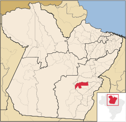 Location of Parauapebas in the State of Pará | |
 Parauapebas Location in Brazil | |
| Coordinates: 6°4′04″S 49°54′07″W | |
| Country | |
| Region | Northern |
| State | Pará |
| Mesoregion | Sudeste Paraense |
| Microregion | Parauapebas |
| Government | |
| • Mayor | Darci José Lermen (PT |
| Area | |
| • Total | 2,658.780 sq mi (6,886.208 km2) |
| Population (2016) | |
| • Total | 196,259 |
| • Density | 74/sq mi (29/km2) |
| Time zone | UTC -3 |
| Postal Code (CEP) | 68515-000 |
| Area code(s) | +55 94 |
| Website | Official website |
Geography
To the north is the municipality of Marabá; to the east, Curionópolis; to the south-east, Canaã dos Carajás; to the south, Água Azul do Norte; to the south-west, Ourilândia do Norte, and to the west, São Félix do Xingu.
The municipality contains part of the Tapirapé-Aquiri National Forest, a 196,504 hectares (485,570 acres) sustainable use conservation unit created in 1989.[6] It contains 68.9% of the Carajás National Forest, a 411,949 hectares (1,017,950 acres) sustainable use conservation unit created in 1998 that includes mining operations in a huge deposit of high-grade iron ore.[7] Carajás Mine is located in the boundaries of the municipality.
Transport
There are direct road connections with Marabá to the north-east, Curionópolis to the east, and Canaã dos Carajás to the south.
The municipality is served by Carajás Airport.
Leisure
Parauapebas Futebol Clube is the municipality's soccer club.
See also
References
- "Divisão Territorial do Brasil" (in Portuguese). Divisão Territorial do Brasil e Limites Territoriais, Instituto Brasileiro de Geografia e Estatística (IBGE). July 1, 2008. Retrieved December 17, 2009.
- "Estimativas da população para 1º de julho de 2009" (PDF) (in Portuguese). Estimativas de População, Instituto Brasileiro de Geografia e Estatística (IBGE). August 14, 2009. Retrieved December 17, 2009.
- "Ranking decrescente do IDH-M dos municípios do Brasil" (in Portuguese). Atlas do Desenvolvimento Humano, Programa das Nações Unidas para o Desenvolvimento (PNUD). 2000. Archived from the original on October 3, 2009. Retrieved December 17, 2009.
- "Produto Interno Bruto dos Municípios 2002-2005" (PDF) (in Portuguese). Instituto Brasileiro de Geografia e Estatística (IBGE). December 19, 2007. Retrieved December 17, 2009.
- "Swallowing Rain Forest, Cities Surge in Amazon". New York Times. 2012-11-24. Retrieved 2012-11-24.
- FLONA do Tapirapé-Aquiri (in Portuguese), ISA: Instituto Socioambiental, retrieved 2016-05-30
- FLONA de Carajás (in Portuguese), ISA: Instituto Socioambiental, retrieved 2016-05-30
Capital: Belém | |||||||||||||||
| Mesoregion Lower Amazonas |
|  | |||||||||||||
| Mesoregion Marajó |
| ||||||||||||||
| Mesoregion Metropolitan Belém |
| ||||||||||||||
| Mesoregion Northeastern Pará |
| ||||||||||||||
| Mesoregion Southeastern Pará |
| ||||||||||||||
| Mesoregion Southwestern Pará |
| ||||||||||||||