Panchkhal
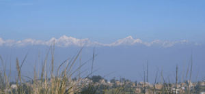
Panchkhal is a Municipality in Kavrepalanchok District in the Bagmati Zone of central Nepal. The Panchkhal Valley, intermontane basin developed in the southeast of the Kathmandu Valley is located within the eastern flank of a synclinorium in Kavre District. The Jhiku Khola, a tributary of the Sun Koshi River is characterised by development of geomorphic surfaces at different elevations formed after the last glacial retreat in the area. Panchkhal has an area of 103 km² and Density: 386.6/km² according to 2011 census.[2] Glacial strand retreat and fluvial incision led to develop landscapes and evolve the area having a relief of about 122 to 750 m.[3] At the time of the 2011 Nepal census it had a population of 35340 & 8948 houses combining of previous VDC that were merged.[4] Previous Aniakot, HokseBazar, Kharelthok, Koshidekha, Baluwa & Panchkhal VDC was merged to form agriculturally rich Panchkhal[5] Municipality.This place is situated in Bagmati, Central, Nepal, its geographical coordinates are 27° 39' 0" North, 85° 37' 0" East and its original name (with diacritics) is Panchkhal.
Panchkhal पाँचखाल | |
|---|---|
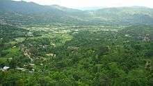
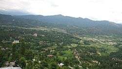 Panchkhal Municipality view with its capital and fertile fields | |
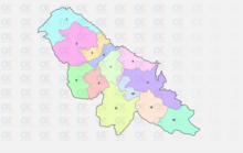
 Panchkhal Location in Nepal | |
| Coordinates: 27°39′N 85°37′E | |
| Country | Nepal |
| Zone | Bagmati Zone |
| District | Kabhrepalanchok District |
| Government | |
| • Mayor | Mahesh Kharel |
| • Deputy Mayor | Laxmi Danuwar |
| Population (2011) | |
| • Total | 35,340 |
| Time zone | UTC+5:45 (NST) |
| Postal code | 45212[1] |
| Area code(s) | 011 |
| Website | www |
Climate
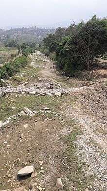
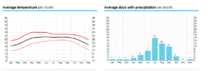
Panchkhal has average temperatures of 24.9 °C and average low 11.66 °C throughout the year. Temperatures may rise up to 38 °C in the summer season and winter are generally dry with record low temperature of -10 °C in 2008. Average rainfall is about 10.2 cm throughout the year. Rainfall is mostly monsoon-based (about 65% of the total concentrated during the monsoon months of June to August), and decreases substantially (100 to 200 cm (39 to 79 in)) from eastern Nepal to western Nepal. In the winter season it rarely rains which creates harsh condition for farmers who mainly depends on rain for irrigation.[6]
Economy
Agriculture
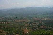
It has flat land and suitable climate for various crops. Araniko highway has accelerated agriculture with connecting Kathmandu and Kodari. Agricultural land use has been changing from one crop to three or more crops rotation per year. That shows intensive use of land and expansion of agricultural activity. Panchkhal comprises two land types; khet (cultivated flat land) and bari (cultivated slope land). Bari covers 41.68percent, followed by 37.14 percent khet. Panchkhal is known for its vegetables. The main cash crop of panchkhal is potato, tomato, chilly, beans, cauliflower, paddy and other seasonal vegetable and food crop are maize, wheat and etc.
Tourism
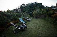
Panchkhal is nearer to the one of the reputed tourist destination of the country Dhulikhel and its natural environment and the culture and traditions of the people living here attracts tourists. Panchkhal shares some resorts with Dhulikhel and one of it is Dhulikhel Mountain Resort located in ward number-5 panchkhal.[7]
Special Economic Zone
A budget of Rs 1.2 billion has been estimated for the construction of SEZ in Panchkhal. The construction of infrastructure at the Panchkhal economic zone, touted as a major facility to promote trade with China. The government has already acquired 1,000 ropanis of land—600 ropanis from the Devisthan Padula Subarnashwori Community Forest and 400 ropanis from the Sikharpur Community Forest. The Industry Ministry has paid Rs200 million to the Ministry of Forest for the land. If the SEZ is brought into operation, more than 50 large factories can be operated there. It can also provide warehousing facilities for goods imported from China.[8]
The Nepal government has a plan to add oil depots in Panchkhal.[9]
Education
Panchkhal Municipality has well managed education facilities. Public and private sector are keen to contribute in education.
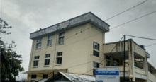
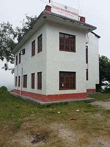
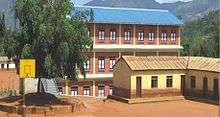
The biggest school in entire panchkhal is Shree Sarbamangala Higher Secondary School.
Shree Sarbamangala Higher Secondary School
Shree Sarbamangala Higher Secondary School is one of the popular government schools in Kabhre district. It is located at Panchkhal of Kabhre district, at a few minutes walking distance away from Tamaghat. Established in 2020 BS, Shree Sarbamangala has produced more than 41 SLC and SEE batches since 2028 BS.[10]
Shree Jorpati Secondary School
Located in Tinpiple-Panchkal, this school is also a famous educational institution in kavre district. It had great improvement in the SLC sector in the recent past few years.
Other School
Azad Higher Secondary School
Saraswati Shiksha Griha(SSG)
Shree Bhakram Devi Secondary School, Dhwaredihi, Anaikot, panchkhal-02
Golden Future higher secondary school
Panchkhal Valley secondary school
Religious Sites
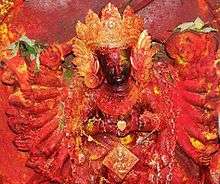
Palanchok Bhagawati Temple
Palanchowk Bhagawati[11] is one of the most important Goddess images in, a three feet tall finely carved on black stone and decked with Jewelry. Many pilgrims visit the temple especially on Tuesday and Saturday and animal sacrificing are also offered to the Goddess. During great Dasain festival season, people from all over make a pilgrimage to Palanchowk Bhagawati.
The district –Kavre Palanchowk– is named after the Goddess. It is 58 km east from, a two hours hilly drive on the . This historic temple is located at a hilltop. It is believed that the Palanchowk Bhagawati, Naxal Bhagawati (in Kathmandu) and Shobha Bhagawati (in ) are sisters and Palanchowk Bhagawati is the eldest among them. And all three idols were made by same sculptor.
Shree Dhanalaxmi Temple ,panchkhal -02
Panchkhal Military
Army Base
Nepal Army Birendra Peace Operations Training Centre (BPOTC) is a renowned training institute of Nepal which is dedicated for providing training to all Nepalese Army personnel participating in various UNPKO. BPOTC is located at Panchkhal which is 45 km East of Kathmandu and lies 942 meters above mean sea level.
The Nepalese Army established an ad hoc "Peace Keeping Training Camp" in 1986, which was subsequently restructured into a dedicated Training centre in 2001. It was renamed as Birendra Peace Operations Training Center with the motto "PEACE WITH HONOUR".[12]

Also a new Nepal Armed police Force (APF) camp is built in panchkhal some meters away from tamaghat.
References
- "Archived copy". Archived from the original on 19 July 2011. Retrieved 19 May 2011.CS1 maint: archived copy as title (link)
- "Panchkhal (Municipality, Nepal) - Population Statistics, Charts, Map and Location". www.citypopulation.de. Retrieved 3 February 2018.
- Timsina, Yadu Nath; Adhikary, Prakash Chandra (2007). "Quaternary stratigraphy of Panchkhal valley, Central Nepal". Bulletin of the Department of Geology. 10: 1–8. doi:10.3126/bdg.v10i0.1415. ISSN 1996-3491.
- "Nepal Census 2011" (PDF). Nepal Census. Retrieved 31 May 2017.
- "Panchkhal Municipality Office | Government of Nepal". www.panchkhalmun.gov.np. Retrieved 30 May 2017.
- "High and dry - Nepali Times". nepalitimes.com. Retrieved 31 May 2017.
- "★★★ Dhulikhel Mountain Resort, Dhulikhel, Nepal". Booking.com. Retrieved 31 May 2017.
- "Panchkhal SEZ project formally recommences". Retrieved 31 May 2017.
- "2 more oil depots to be built to boost reserves". Retrieved 31 May 2017.
- "Sarbamangala Higher Secondary School Panchkhal-4 Kavrepalanchok". edusanjal.com. Retrieved 30 May 2017.
- "PHALANO.com » Palanchowk Bhagawati". www.phalano.com. Retrieved 30 May 2017.
- "Birendra Peace Operations Training Centre". bpotc.mil.np. Retrieved 30 May 2017.