Pampas
The Pampas (from the Quechua: pampa, meaning "plain") are fertile South American lowlands that cover more than 1,200,000 km2 (463,322 msq) and include the Argentine provinces of Buenos Aires, La Pampa, Santa Fe, Entre Ríos and Córdoba; all of Uruguay; and Brazil's southernmost state, Rio Grande do Sul. The vast plains are a natural region, interrupted only by the low Ventana and Tandil hills, near Bahía Blanca and Tandil (Argentina), with a height of 1,300 m (4,265 ft) and 500 m (1,640 ft), respectively.
Pampas | |
|---|---|
Natural region | |
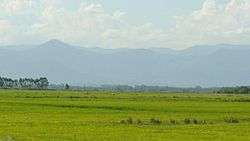 Landscape in the Pampas at eye level. Brazil. | |
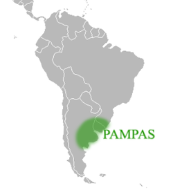 Approximate location and borders of the Pampas encompassing the southeastern area of South America bordering the Atlantic Ocean | |
| Countries | |
| Elevation | 160 m (520 ft) |
| Population | |
| • Total | 42,000,000 |
The climate is temperate, with precipitation of 600 to 1,200 mm (23.6 to 47.2 in) that is more or less evenly distributed through the year, making the soils appropriate for agriculture. The area is also one of the distinct physiography provinces of the larger Paraná-Paraguay Plain division.
Climates
The climate of the Pampas is generally temperate, gradually giving way to a more subtropical climate in the north and to a semiarid climate on the western fringes (like San Luis Province and western La Pampa Province). Summer temperatures are more uniform than winter temperatures, generally ranging from 28 to 33 °C (82 to 91 °F) during the day. However, most cities in the Pampas occasionally have high temperatures that push 38 °C (100 °F), as occurs when a warm, dry, northerly wind blows from southern Brazil. Autumn arrives gradually in March, and peaks in April and May. In April, highs range from 20 to 25 °C (68 to 77 °F) and lows from 9 to 13 °C (48 to 55 °F). The first frosts arrive in mid-April in the south, and in late May or early June in the north.
Winters are generally mild, but cold waves often occur. Normal temperatures range from 12 to 19 °C (54 to 66 °F) during the day, and from 1 to 6 °C (34 to 43 °F) at night. With strong northerly winds, days of over 25 °C (77 °F) can be recorded almost everywhere, and during cold waves, high temperatures can be only 6 °C (43 °F). Frost occurs everywhere in the Pampas, but it is much more frequent in the southwest than around the Parana and Uruguay Rivers. Temperatures under −5 °C (23 °F) can occur everywhere, but values of −10 °C (14 °F) or lower are confined to the south and west. Snow never falls in the northernmost third and is rare and light elsewhere, except for exceptional events in which depths have reached 30 cm (12 in).
Springs are very variable; it is warmer than fall in most areas (especially in the west) but significantly colder along the Atlantic. Violent storms are more common as well as wide temperature variations: days of 35 °C (95 °F) can give way to nights of under 5 °C (41 °F) or even frost, all within only a few days.
Precipitation ranges from 1,200 mm (47 in) in the northeast, to about 500 mm (20 in) in the southern and western edges. In the west, it is highly seasonal, with some places recording averages of 120 mm (4.7 in) monthly in the summer, and only 20 millimetres (0.8 in) monthly in the winter. The eastern areas have small peaks in the fall and in the spring, with relatively rainy summers and winters that are only slightly drier. However, where summer rain falls as short, heavy storms, winter rain falls mostly as cold drizzle and so the amount of rainy days is fairly constant. Very intense thunderstorms are common in the spring and summer, and it has among the most frequent lightning and highest convective cloud tops in the world.[1][2] The severe thunderstorms produce intense hailstorms, and both floods and flash floods, as well as the most consistently active tornado region outside the central and southeastern US.[3]
Wildlife
Human activity has caused major changes to the wildlife of the Pampas. Species such as the puma, rhea, and Pampas deer have lost their habitats especially due to the spread of agriculture and ranching.[4]
Herbivores of the pampas are the pampas deer, gray brocket, plains viscacha, Brazilian guinea pig, southern mountain cavy and coypu. The biggest predator of the region is the puma followed by the maned wolf, pampas fox, geoffroy's cat, lesser grison as well as the omnivorous white-eared opossum and molinas hog-nosed skunk.
Bird species of the pampas are ruddy-headed goose, pampas meadowlark, hudsonian godwit, maguari stork, white-faced ibis, white-winged coot, southern screamer, dot-winged crake, curve-billed reedhaunter, burrowing owl and the rhea.[5][6][7][8][9]
Invasive species include the European hare, wild boar and house sparrow.
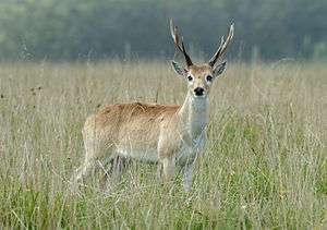 Pampas deer
 Pampas fox
.JPG) Rhea
Rhea.JPG) Southern screamer
Southern screamer
Vegetation
| Regions of Argentina |
|---|
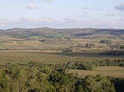
Frequent wildfires ensure that only small plants such as grasses flourish, and trees are less common. The dominant vegetation types are grassy prairie and grass steppe in which numerous species of the grass genus Stipa are particularly conspicuous. "Pampas grass" (Cortaderia selloana) is an iconic species of the Pampas. Vegetation typically includes perennial grasses and herbs. Different strata of grasses occur because of gradients of water availability.
The World Wildlife Fund divides the Pampas into three distinct ecoregions. The Uruguayan Savanna lies east of the Parana River, and includes all of Uruguay, most of Entre Ríos and Corrientes provinces in Argentina, and the southern portion of Brazil's state of Rio Grande do Sul. The Humid Pampas include eastern Buenos Aires Province, and southern Entre Ríos Province. The Semiarid Pampas includes western Buenos Aires Province and adjacent portions of Santa Fe, Córdoba, and La Pampa provinces. The Pampas are bounded by the drier Argentine espinal grasslands, which form a semicircle around the north, west, and south of the Humid Pampas.
Winters are cool to mild and summers are very warm and humid. Rainfall is fairly uniform throughout the year, but is a little heavier during the summer. Annual rainfall is heaviest near the coast and decreases gradually further inland. Rain during the late spring and summer usually arrives in the form of brief heavy showers and thunderstorms. More general rainfall occurs the remainder of the year as cold fronts and storm systems move through. Although cold spells during the winter often send nighttime temperatures below freezing, snow is quite rare. In most winters, a few light snowfalls occur over inland areas.
Central Argentina boasts a successful agricultural business, with crops grown on the Pampas south and west of Buenos Aires. Much of the area is also used for cattle and more recently to grow vineyards in the Buenos Aires wine region. The area is also used to farm honey using European honeybees. These farming regions are particularly susceptible to flooding during the thunderstorms. In the Pampas, the weather averages out to be 60 °F (16 °C) year round.
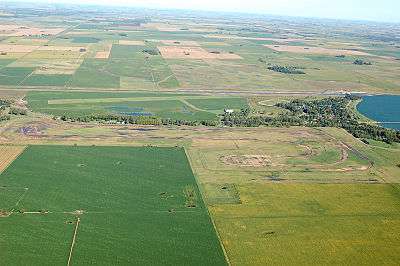 View of the northern Pampas grain belt |
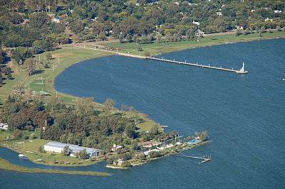 Lake Gómez, near Junín, in the heart of the Pampas grain belt: The Pampa extends from the foothills of the Andes Mountains on the west to the Atlantic Ocean on the east. The region is peppered with finger lakes, holdovers from the last ice ages. |
Population
![]()
![]()
![]()
![]()
![]()
![]()
![]()
![]()
Immigration
Starting in the 1840s but intensifying after the 1880s, European immigrants started to migrate to the Pampas, first as part of government-sponsored colonization schemes to settle the land and later as tenant farmers "working as either sharecroppers or as paid laborers for absentee landowners"[10] in an attempt to make a living for themselves.
However, many immigrants eventually moved to more permanent employment in cities, as industrialization picked up after the 1930s. As a result, Argentina's history of immigration in Buenos Aires Province is typically associated with cities and urban life, unlike in Entre Ríos Province and Santa Fe Province, where European immigration took on a more rural profile.
See also
- Dry Pampa
- Estancia
- Federal University of Pampa
- Gaucho
- Humid Pampas
- Médanos wines
- Médanos (dunes)
- Riograndense Republic
- Luis Ángel Firpo - the "Wild Bull of Las Pampas"
- José Froilán González - the "Pampas Bull"
- Southern jaguar
- Southern Cone
References
- Zipser, E. J.; C. Liu; D. J. Cecil; S. W. Nesbitt; D. P. Yorty (2006). "Where are the Most Intense Thunderstorms on Earth?" (PDF). Bull. Am. Meteorol. Soc. 87 (8): 1057–1071. doi:10.1175/BAMS-87-8-1057.
- Virts, Katrina S.; J. M. Wallace; M. L. Hutchins; R. H. Holzworth (2013). "Highlights of a New Ground-Based, Hourly Global Lightning Climatology". Bull. Am. Meteorol. Soc. 94 (9): 1381–91. doi:10.1175/BAMS-D-12-00082.1.
- Rasmussen, Kristen L.; M. D. Zuluaga; R. A. Houze Jr. (2014). "Severe convection and lightning in subtropical South America". Geophys. Res. Lett. 41 (20): 7359–66. doi:10.1002/2014GL061767.
- "Southern South America: Southeastern Argentina | Ecoregions | WWF". World Wildlife Fund. Retrieved 2020-02-20.
- WWF ecoregions: https://www.worldwildlife.org/ecoregions/nt0803
- IUCN redlist: http://oldredlist.iucnredlist.org/details/6786/0
- IUCN redlist: http://oldredlist.iucnredlist.org/details/4819/0
- IUCN redlist: http://oldredlist.iucnredlist.org/details/22689353/0
- IUCN redlist: http://oldredlist.iucnredlist.org/details/29620/0
- Meade, Teresa A. History of modern Latin America: 1800 to the present. Wiley Blackwell, 2016.
External links
| Wikisource has the text of The New Student's Reference Work article "Pampas". |